Note : Les descriptions sont présentées dans la langue officielle dans laquelle elles ont été soumises.
PATENT
9256
Rai/Sondergeld
~3~3~
"A METHOD AND SYSTEM OF GEOPHYSIC~L
EXP~ORATION"
Background of the Invention
The present invention relates generally to a
method and system of geophysical exploration and more par-
ticularly to a method and system for obtaining a composi-
tion log of the minerals comprising the earth's15
subterranean formations surrounding a wellbore.
In the continuing search for oil and gas, explo-
rationists have developed a wide array of geophysical
exploration methods for imaging the earth's subterranean
formation structures and displaying those images as well
as providing estimates of selected formation character
istics such as lithologyt porosity, density, and velocity
of propagation of seismic energy in the earth's forma-
tions. Exemplary of such geophysical exploration methods
are seismic surveys, gravity surveys, magnetic surveys,
: 25
acoustic logging, resistivity logging and neutron logging.
Occasionally, core samples are o~tained from
regions of interest within a limited portion of the well-
bore for transport to a central laboratory so tnat proper-
ties of khe formations adjacent the borehole, such as
-2~ 3 3 ~
fluid content of the sample, (U~S. Patent 2,458,093, M.
Muskat, et al., January 4, 1949), oil content of the
sample (U.S. Patent 2,531,083, A. L. Smith, November 21,
1950), and resistivity of the sample (U.S. Patent
2,613,250, H. L. Bilhartz, et al., October 7, 1952) can be
obtained. Additionally, analyses of such core samples to
determine mineralogy have been undertaken at remote labo-
ratory facilities. Unfortunately, such core samples gen-
erally represent only a small fraction of the formation
lithologies traversed by the wellbore along its length and
as such the measured properties represent only a small
fraction of the earth's formations surrounding the well-
bore.
During the drilling process, chips which have
broken away from the subsurface formations can be c~ptured
from the drilling fluid at the surface or analysis. Typ-
ically, explorationists have identified the lithologies of
the subsurface formations from such chips. However,
determining the exact depth in the wellbore from which the
chips originated is generally not possible due to the very
nature of their transport to the surface. Consequently,
core samples and chip samples fail to provide either a
regular sampling of borehole formation lithologies along
the length of the wellbore or fail to accurately determine
the depth of origin of such samples so that logs of forma-
tion characteristics, as a function of depth over gener-
ally the entire wellbore length, cannot be produced.
~ 3~3~
Moreover, the very nature of the chip samples can often
times preclude measuring certain formation characteristics
(for example, measurement of seismic velocity or compres-
sive strength3.
In view of such difficulties, the present
invention provides a novel method of geophysical explora-
tion whereby a composition log of the minerals comprising
the formations surroundlng a wellbore can be obtainedO
With such composition logs, explorationists can better
evaluate the results of geophysical surveys and thus
better evaluate the oil- and gas-bearing potential of such
formations.
Summary of the Invention
~ he present invention provides a novel method of
geophysical exploration whereby a composition log of the
minerals comprising the formations surrounding a wellbore
can be obtained. With such composition logs, exploration-
ists can better evaluate the results of geophysical sur-
veys and thus better evaluate the oil~ and gas bearing
potentials of such formations.
Samples of the earth's formations surrounding a
wellbore are obtained at selected intervals along the
length of the wellbore. Each of the samples is irradiated
with electromagnetic radiation and a spectral response
signal, representative of the electromagnetic radiation
response of each sample, is recorded. Peaks in the spec-
tral response signals are located and correlated with min-
_4_ ~3~33~ -
erals exhibiting similar electromagnetic characteristic
response peaks. Since the samples were obtained from
known depths within the wellbore, a composition log of the
minerals comprising the formations surrounding the well-
bore can be prepared displaying the minerals identified as
a function of depth in the wellbore.
In one embodiment of the invention, the samples
are irradiated with infrared radiation and a spectral
response signal is obtained which is representative of the
infrared radiation absorbed by each sample. The spectral
location and amplitude of each characteristic peak in the
spectral response signal can be obtained. By correlating
the spectral location of the characteristic peaks in the
spectral response signal of each sample with minerals
exhibiting similar characteristic peaks, a qualitative
measure can be obtained of the minerals comprising the
formation surrounding the wellbore as represented in each
sample. By employing the spectral location and relative
amplitude of the characteristic peaks, a regression analy-
sis can be performed using the spectral locations and rel-
ative amplitudes of a plurality of samples with known
compositions to determine a quantitative measure of the
minerals in each sample.
Brief Description of the Drawings
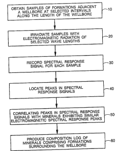
Figure 1 is a flow diagram of the present
invention;
_5_ -~ 3~ ~ ~3~
Figure 2 is a representation of a spectral
absorption 5 ignal;
Figure 3 is a waterfall plot of a plurality of
spectral absorption signals as a function of depth;
Figure 4 is a color photograph of a composition
log of subterranean formations around a wellbore;
Figure 5 is a flow diagram for obtaining a quan-
titative measure of minerals in samples of formations sur-
rounding the wellbore; and
Figure 6 is a composition log of the minerals
comprising the ormation surrounding the wellbore.
DETAILED DESCRIPTION OF THE INVENTION
The present invention relates generally to a
method of geophysical exploration and more particularly to
a method and system for obtaining a composition log of the
minerals comprising the earth's formation surrounding a
wellbore.
Looking first to Figure 1, a flow diagram of the
present invention is depicted. In one embodiment of the
invention, eore samples are obtained over substantially
the entire wellbore length; however, an important aspect
of the present invention is that discrete samples of the
earth's formation surrounding a wellbore need only be
taken at selected intervals along the length of the well-
bore at step 10. One criteria for establishing the sampl-
ing intervals is that discrete samples generally be
obtained for every formation lithology traversed by the
-6- ~3~ ~3~
wellbore along its length. Since the mineral composition
of the formations surrounding the wellbore can also be
used to evaluate geophysical survey data (e.g., seismic
survey data), the minimum resolution interval of the geo-
physical survey data being evaluated establishes another
criteria for the sampling interval. Typically seismic
data has the finest resolution interval of any geophysical
survey techni~ue (approximately 100 ft). In practicel we
have found that a sampling interval of one sample every
10 ft adequately addresses the criteria of lithology
changes as well as the geophysical survey minimum resol-
ution interval criteria so as to address the problems of
heterogeneous rather than homogeneous earth formations so
that the mineral composition of the samples obtained at
step 50 below can be correlated with geophysical survey
data without introducing sampling bias.
To prepare the samples for step 20, a portion of
each sample is ground with a hammer in a metallic crucible
to a size of less than 1/32 of an inch. The ground sample
is then pulverized for approximately 20-30 minutes in a
ball mill. After ball milling, the powdered sample can
then be ground finer using a mortar and pestle. When the
grinding is complete, the rock sample should have no dis-
cernible grains left. Preferably, the grain size of the
powered sample should be less than the wavelength of a
probing electromagnetic beam used to ascertain the mineral
composition of the sample. The powdered sample can then
--7--
be heated in a vacuum for a period of time to drive off
all free moisture. The dried and finely powdered sample
is then mixed with dried salt such as potassium bromide in
a fixed proportion for all samples. Salt employed should
be transparent to the probing electromagnetic radiation in
the wavelengths of interest. The sale ancl powdered sample
pellet is then produced in a pressurized die assembly.
At step 20, the sample pellets are mounted in a
specimen carrier and inserted into a sample chamber of an
electromagnetic spectral analysis instrument. While
several types of transmission, reflection and absorption
spectral analysis instruments are available (for example,
X-ray diffraction, X-ray fluorescence, and infrared
absorption), we have found that a Fourier transform infra-
red spectrometer (FTIR) type instrument is preferable
because of its ease and speed of operation. Typical X-ray
instrumentation requires water cooling for the X-ray
source and are very bulky and can take up to one hour to
obtain results. Consequently, field deployment of the
present invention generally precludes the use of X-ray
instrumentation. The FTIR irradiates each sample with
infrared radiation for a period of approximately 60 sec-
onds.
As the result of irradiating the sample with
infrared radiation, a spectral response signal can be
recorded at 30 whereby a measure of the sample's absorp-
tion of selected wavelengths of the infrared radiation is
~ 3~3~
-8-
obtained. A representation of a spectral response signal
is shown in Figure 2. At step 40, the spectral location
and relative amplitude of the characteristic peaks of the
spectral response signal are obtained (as indicated in
Figure 2). The characteristic peaks can then be corre-
lated with minerals exhibiting similar infrared character-
istic response peaks at 50. For example, the peaks A, B,
C, and D can each represent a different mineral. We have
found it most advantageous to have a computer (not shown)
receive the spectral response signals to locate the char-
acteristic peaks and correlate the characteristic peaks
with a stored table of infrared characteristic peaks of a
wide array of minerals to identify the minerals repres-
ented by the spectral response signals of each sample.
At step 60, the minerals identified from
step 50, and as depicted in Figure 2, can be displayed as
a composition log of the minerals comprising the forma-
tions surrounding the wellbore as a function of depth.
Such display can be output to a CRT screen of a computer
system, a plotter, or a printer. Representative of such
displays are Figures 3, 4, and 6. In particular, Figure 3
is a waterfall plot representation of a series of spectral
response signals plotted adjacent one another in depth
sequence in which the characteristic peaks A, B, C, and D
of Figure 2 can be seen to occur in various combinations
as a function of depth. To highlight those segments of
the spectral response signals which can be correlated with
:~ 3 ~
g
selected minerals, color bands encompassing a selected
range of wavelengths can be overlaid on the display of
Figure 3 as indicated by the separate dashed lines. The
occurrence of a peak on the spectral response signal
within a color band indicates the presence of a particular
mineral. Figure 4 represents a composition log obtained
from the spectral response signals from an actual well.
An alternative display can be produced as shown in
Figure 6 which is simply a plot of the various minerals
identified as a function of depth with each mineral either
color-coded, color shade-coded or indicated by separate
symbol.
By observing the relative amplitude and spectral
location of such characteristic peaks in each spectral
response signal, one can determine the relative weight
percentage of any mineral in a sample. In particular, to
determine the relative amount of a mineral G in an unknown
sample, the relative amplitudes Is and spectral location
of the characteristic peaks in a spectral response signal
of an unknown sample can be compared to relative ampli-
tudes Io and spectral locations of the characteristic
peaks in a spectral response signal of the pure mineral G.
; The ratio of such relative amplitudes IS/Io varies with
the concentration of mineral G in the sample and can
depend markedly on the other elements present and cannot,
in general, be predicted by calculation. It is, there-
fore, necessary to establish the variation by obtaining
'
~3~3~
--10--
measurements on a plurality of samples of known composi-
tion and through a regression analysis determine the rela-
tive amount of mineral in a sample. Such quantltative
mineralogy information can then be displayed by varying
the width of the line segment representing a particular
mineral as depicted in Figure 6.
~ ith reference now to Figure 5, a method for
obtaining a quantitative measure of the minerals compris-
ing the formations surrounding the wellbore is depicted.
At step 70, a plurality of standard samples having known
weight percentages of the basic lithologies of interest,
i.e., sandstone, shale, and carbonates are prepared. A
set of regression coefficients are established for the
standard samples. These regression coefEicients describe
the attributes of spectral peak location such as ampli-
tude, slope, area, moment, and skewness as a function of-
varying lithologies. At step 80, the regression coeffi-
cients for the lithologies are evaluated to determine
which set provides the best fit with the spectral response
peak attributes for the sample. The decision at step 80
is premised on the major mineral comprising the litholo-
gies of interest, i.e., quartz in sandstone, clays in
shales, calcites and dolomites in carbonates. Having
identified the primary lithology or mineral constituents
of the sample, one of a set of three separate regression
analyses are concluded at 90, 100 and 110. In particular,
the re~ression coefficients in each of these separate
steps were obtained employing samples of known mineral
compositions in which the identified mineral was the pri-
mary mineral contained in the sample. For example, the
shale regression coefficient can be made when clays com-
prise at least 20% of the sample. Using these two step
processes, a more accurate measurement of relative amount
of a mineral in a sample can be obtained. At step 120, a
quantitative composition log similar to Figure 6 can be
produced. The scale in Figure 6 is in relative weight
percent from 0 to 100~.
Having described the method and system of the
present inventionl it is to be understood that various
modifications or changes may be made without departing
from the scope of the invention as set forth in the claims
below.
'