Note : Les descriptions sont présentées dans la langue officielle dans laquelle elles ont été soumises.
2040977
METHODS FOR MEASUREMENT, ANALYSIS AND ASSESSMENT OF
GROUND STRUCTURE
BACKGROUND OF THE INVENTION
Technical Field
The present invention relates to methods for
measurement, analysis and assessment of ground struc-
tur a .
Background Art
To determine the structure and characteristics of
the surface layer of the ground, it has heretofore been
necessary to drill a plurality of holes in the ground
and insert or indwell instruments and ancillary devices
into the holes and also to employ a source of oscilla-
tion for generating waves to be measured. It should,
therefore, be obviously of great benefit if it were
ever possible to know the structure and characteristics
of the surface layer of the ground without any of such
efforts and contrivances. To this end, it might be
contemplated to measure and analyze the oscillatory
waves or microseisms observed in the surface layer of
the ground. However, up to the present time, there is j
not known a measuring technology or a system of instru-
mental analysis, by means of which short-period micro-
seisms could be measured with sufficient accuracy to
204077
- 2 -
estimate the tectonic and other characteristics of the
surface layer of the ground inclusive of the velocity
of shear (S) waves.
Furthermore, the prior art system designed to
simultaneously measure short-period microseisms at a
plurality of points to thereby delineate the ground
structure has the following disadvantages.
A. Since the spacings of oscillation sensors must be
large, that is to say the scale of measurement must be
large, a large free area is required and it is time-
consuming to connect the cords from the respective
oscillation sensors for cental analysis. Moreover,
because the large number of oscillation sensors are
required, the analytical procedure is scaled up to the
extent that the method cannot be utilized advantage-
ously in the field.
B. Since the network of oscillation sensors is not
tailored to improvement in measuring accuracy or
resolution of high-order modes, the reliability of the
measured dispersion curve is low.
C. Short-period microseisms include not only substan-
tive waves such as dilatational (P-) waves and S-waves
but surface waves such as Rayleigh and Love waves.
Since the confirmation or judgement of whether the
detected waves are surface waves or not is not per-
~a4a97~
- 3 -
formed at measurement or analysis, it is impossible to
judge whether the dispersion curve obtained is relevant
to the surface waves and, hence, to accurately deter-
mine the ground structure.
D. Since short-period waves include higher-modes
surface waves, it is impossible to compute an accurate
surface wave dispersion curve and, hence, to ascertain
the surface layer structure of the ground unless some
means for removing or separating these waves are
available.
E. Since the dispersion curve cannot be computed
real-time from field values, there is no knowing
whether measurements were made with acceptable accu-
racy.
OBJECT OF THE INVENTION
It is an object of the present invention to
provide a method for measurement, analysis and assess-
ment of ground structure whereby the laminar structure
and characteristics of the ground can be determined
quickly, expediently and accurately through simulta-
neous ground-level observation and analysis of short-
period microseisms even in a confined available land.
It is another object of the present invention to
provide a method for measurement, analysis and assess-
ment of ground structure which does not call for drilling
~' 2040977
- 4 -
of holes or the use of an oscillation source.
It is a further object of the invention to provide
a method for measurement, analysis and assessment of
ground structure in which the accuracy of measurement
and analysis has been improved by using a network of
substantially equi-spaced oscillation sensors which
facilitates field sensor positioning as well.
It is another object of the present invention to
provide a method for measurement, analysis and assess-
ment of ground structure by which the laminar structure
and characteristics of the ground can be ascertained
with accuracy through selective extraction of surface
waves.
It is still another object of the present inven-
tion to provide a method for measurement, analysis and
assessment of ground structure by which the accuracy of
assessment of the ground structure can be improved by a
collective analysis of data obtained by repeated
measurement using dissimilar sensor-to-sensor distances.
It is still another object of the present invention
to provide a method for measurement, analysis and
assessment of ground structure by which the laminar
structure and characteristics of the ground can be
evaluated conveniently and accurately on a real-time
basis.
2040977
- 5 -
SUMMARY OF THE INVENTION
The present invention is predicated on the facts
that when surface waves such as Rayleigh waves are
propagated through a horizontal multi-layer ground
structure, phase velocity (the velocity of propagation)
varies with different wavelengths (dispersions), that
the apparent phase velocity can be computed by averag-
ing the correlation coefficients of the waveforms
measured by equi-spaced oscillation sensors in differ-
ent directions, that this apparent phase velocity
varies with different sensor-to-sensor differences due
to the influence of higher-order modes, and that when
the horizontal and vertical components of the motion of
a particle on the ground surface due to propagation of
oscillations are detected and synthesized, the locus of
rotation or orbit of a particle on the ground surface
can be constructed, and that such surface waves are
present in short-period microseisms as well. As such,
the present invention is directed to a method for
measurement, analysis and assessment of surface wave
dispersion curves which serve as bases for evaluation
of the tectonic and elastic characteristics of the
ground by repeated simultaneous measurement of short-
period microseisms at a plurality of points in a simple
small-scale measuring system wherein 3 or more oscilla-
tion sensors are disposed at substantially equal
T 204077
- 6 -
sensor-to-sensor distances within a comparatively small
area and inverse analysis of the surface wave dispersion
curves at the points of measurement to compute the S-wave
velocity of the ground and evaluate the laminar structure
and features of the ground.
In the first aspect, the present invention provides a
method for estimating the laminar structure of a ground
which comprises disposing an oscillation sensor adapted to
detect the vertical component or the vertical and
horizontal components of oscillations at each of at least 3
points within a comparatively narrow area and thereby
measuring microseisms at such plural points simultaneously,
if necessary changing the points of measurement and
repeating the measurement, and analyzing the vertical
oscillation data or vertical and horizontal oscillation
data, thereby computing the S-wave velocity of the ground,
by which the laminar structure of the ground is estimated.
In the second aspect, the present invention is
directed to a method according to the first aspect wherein
said microseisms to be measured are short-period
microseisms observed.
In the third aspect, the present invention is
directed to a method according to said first aspect wherein
two oscillation sensors are disposed on each of 2 or more
2Q40977
straight lines passing through the ground to be measured
and dividing the azimuth of 360 degrees into an even-number
of sections or straight lines parallel thereto in such a
manner that all sensor-to-sensor distances are equal on
each of said straight lines.
In the fourth aspect, the present invention provides
a method according to said first aspect wherein said
oscillation sensors are disposed at 3 or more points with
equal spacings on the circumference of a circle and at one
point in the center of the circle, or at a total of at
least 4 points.
In the fifth aspect, the present invention provides a
method according to said first aspect wherein said
oscillation sensors are disposed at apices of a regular
triangle and the center of gravity thereof or a total of 4
points.
In the sixth aspect, the present invention is
directed to a method as in any previous aspect which
comprises judging whether the oscillation waves detected by
said oscillation sensors are surface waves or not, and
extracting and analyzing the surface waves.
. '~
--~ , 204077
_8_
In the seventh aspect, the present invention is
directed to a method as in any previous aspect which
comprises analyzing the correlation coefficients and phase
differences of oscillation data measured by equi-spaced
oscillation sensors at respective frequencies, performing
the analysis for each of varying sensor-to-sensor
distances, analyzing and computing the fundamental mode of
surface waves based on results of the respective analyses
and, if necessary, analyzing and completing the higher-mode
wavelengths.
In the eighth aspect, the present invention relates
to a method as in any previous aspect, which comprises
performing the measurement and analysis of microseisms
repeatedly until it can be concluded that a relation
between phase velocity and wavelength such as to give a
sufficiently accurate evaluation of ground structure can be
achieved.
Thus, in accordance with the present invention, ,
oscillation sensors for detecting the vertical component or
the vertical and horizontal components of a vibration are
disposed at 3 or more points within a comparatively small
area at ground level and the microseisms are measured
simultaneously at said points, if
..
2040977
_ g _
necessary changing the locations of said points of
measurement and the resulting vertical oscillation data
or vertical and horizontal oscillation data are ana-
lyzed. By measuring microseisms with a small network
of oscillation sensors, the accuracy of assessment of
the surface structure of the ground can be improved and
a system enabling a rapid field measurement, analysis
and assessment can be constructed. Therefore, the
laminar structure and characteristics of the ground can
be estimated expediently, positively and accurately.
Furthermore, the present invention is concerned
with short-period microseisms which can be easily
measured at ground level and as such does not require
drilling and placement of instruments in the drilled
holes or the use of an oscillation source so that the
measurement and analysis of ground structure can be
easily performed in any location.
Moreover, since the network of oscillation sensors
for measurement can be set up in a comparatively
confined area, the measurement is facilitated and can
be performed even in a small plot of land.
In addition, when the vertical and horizontal
oscillation data are analyzed and the locus of rotation
~0~0~7~
1~ -
of a particle on the ground surface due to propagation
of oscillations is constructed and the analysis and
assessment are carried out on confirming that the
measured waves are surface waves, the P and S waves can
be differentiated and the surface waves only be posi-
tively measured to provide accurate information on the
ground structure.
Moreover, when oscillation sensors are disposed in
a network wherein sensor-to-sensor distances are sub-
stantially equal and the measurement of waves is
repeated varying the sensor-to-sensor distances, the
high-mode surface waves can be isolated from the
fundamental mode, with the result that a highly accu-
rate relation of dispersion wave to wavelength can be
obtained. It is because the analytical system is
constructed using a microcomputer that the assessment
can be obtained on the spot.
Moreover, when it is so arranged that the measure-
ment of microseisms, amplification of detected signals
and the analysis and assessment of data are automati-
cally performed as a sequence, the relationship between
dispersion curve and wavelength can be more accurately
determined in the field.
EFFECTS OF THE INVENTION
In accordance with the present invention, a
_ 2~4n~77
plurality of oscillation sensors for detecting the
vertical component or vertical and horizontal compo-
nents of oscillations are arranged at 3 or more points
in a comparatively small area, the measurements of
microseisms at the respective points are simultaneously
performed, if necessary varying the locations of said
points and repeating the measurements, and the measured
vertical oscillation data or vertical and horizontal
oscillation data are analyzed to ascertain the laminar
structure and characteristics of the ground. There-
fore, the laminar structure and other characteristics
of the ground can be determined not only expediently,
positively and accurately but even when the area
available for measurement is confined.
In the second aspect of the present invention
wherein said microseisms to be measured are short-
period microseisms observed on the surface of the
ground, the laminar structure and other characteristics
of the ground can be determined without calling for
drilling of holes or the use of an oscillation source
in addition to realization of the effects achieved by
the first aspect of the invention.
According to the third aspect of the invention,
two oscillation sensors are arranged on two or more
straight lines passing through the ground to be mea-
.:.....
2040977
- 12 -
sured and dividing the azimuth of 360 degrees into an
even-number sections or straight lines parallel thereto
in such a manner that the distance between the oscilla-
tion sensors is constant on each of said straight
lines, with the result that, in addition to the effects
of the first aspect of the invention, the field instal-
lation of the oscillation sensors is facilitated and,
moreover, because the sensor-to-sensor distance is
constant in different directions, the accuracy of
measurement and analysis is improved.
Comparable effects are obtained in the fourth and
fifth aspects of the present invention.
In accordance with the sixth aspect of the present
invention, the vertical oscillaton data or vertical and
horizontal oscillation data measured simultaneously by
said oscillation sensors are analyzed to see whether
the oscillation waves detected by the oscillation
sensors are surface waves or not and the laminar
structure and other characteristics of the ground are
still more accurately estimated from the accurate
dispersion curves constructed by extraction and selec-
tive analysis of the surface waves.
In accordance with the seventh aspect of the
present invention, the correlation coefficients and
phase differences of the oscillation data measured by
~U~Q97'~
- 13 -
oscillation sensors disposed at equal spacings for the
respective wavelength are analyzed, varying the sensor-
to-sensor difference and repeating the measurements
and, based on results of the respective analyses, the
fundamental mode of the surface waves is analyzed and
computed. If necessary the wavelength of the higher
mode is analyzed and computed to assess the laminar
structure and characteristics of the ground. There-
fore, in addition to the effects of the first to the
sixth aspect of the invention, the higher mode surface
waves which could not be easily isolated in the past
can be neatly isolated for insuring a further improve-
ment in the accuracy of assessment of ground structure.
In accordance with the eighth aspect of the
invention, the measurement of microseisms and the
analysis of measured microseismic data are continued
until a relationship between phase velocity and wave-
length such that the ground structure can be determined
with sufficient accuracy is obtained so that the
laminar structure and characteristics of the ground can
be determined expediently, rapidly and accurately on a
real-time basis.
BRIEF DESCRIPTION OF THE DRAWINGS
Fig. 1 is a view showing the arrangement of
oscillation sensors in an embodiment of the present
2040977
- 14 -
invention;
Fig. 2 is a schematic view showing the measure-
meat, analysis and assessment system of the same;
Figs..3 and 4 each is a flow chart for illustrat-
ing the procedure of said analysis and assessment;
Fig. 5~is a schematic view showing the measured
and theoretical dispersion curves;
Fig. 6 is a tectonic characteristic diagram obtained by
inverse analysis of the measured and theoretical dispersion
curves according to the elastic wave propagation theory; and
Fig. 7 (a) through (d) are other arrangements of
oscillation sensors.
DETAILED DESCRIPTION OF PREFERRED EMBODIMENTS
The preferred embodiments of the present invention
are described in detail.
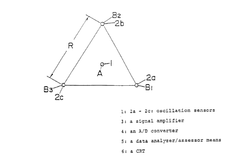
Referring to Figs. 1 and 2 which illustrate a
typical arrangement of oscillation 'sensors and a
schematic representation of the system embodying the
principles of the invention, a three-component oscil-
lation sensor 1 for detecting the vertical component of
oscillation and the bidirectional horizontal component
of oscillation as disposed in one position at ground
level and a plurality of vertical-component oscillation
sensors 2a, 2b and 2c as disposed at positions corres-
ponding to the apices B1 through B3 of a regular
20~097'~
- 15 -
triangle with the length of one side being R and the
center of gravity coinciding with said one point A.
The above-mentioned oscillation sensors 1 and 2a
through 2c each comprises a speedometer and a dis-
placement meter. In the above arrangement, the short-
period microseisms are simultaneously measured.
The detection signal outputs from the respective
oscillation sensors 1 and 2a through 2c are amplified
by a signal amplifier 3 (Fig. 2) and then, fed to a
data analyzer-assessor means 5, comprised of a micro-
computer, through an A/D converter 4 (interface).
The data analyzer/assessor means 5 analyzes the
input data according to the processing flow shown in
Fig. 3 to compute provisional dispersion curves and
displays the curves on a cathode-ray tube CRT 6.
The measurement, analysis and assessment functions
of the system are described in detail below, referring
to the flow charts shown in Figs. 3 and 4.
Referring back to Fig. 1, the vertical and hori-
zontal oscillation detection signal outputs from the
oscillation sensors 1 and 2a through 2c located at
points A and B1 through B3 are respectively amplifi-
ed in the signal amplifier 3 and, after A/D conversion,
are fed to said data analyzer/assessor means 5 for data
analysis ((1) in Fig. 3).
~0~0077
- 16 -
The oscillation data are filtered ((2), Fig. 3)
and subjected to spectrum analysis inclusive of FFT
(high-speed Fourier transformation) to determine the
coherence, correlation coefficient and phase difference
of waves detected by the plural equi-spaced oscillation
sensors for each of the frequencies (f) involved (Fig.
3, (3)). When there is horizontal component data (Fig.
3, (4)), the direction of approach of the dominant wave
is determined (Fig. 3, (5)), the horizontal component
data measured by oscillation sensors 1 and 2a through
2c are analyzed in a direction perpendicular to the
direction of approach of the waves (Fig. 3, (6)), and
the movements of the ground surface in the planes
parallel and perpendicular to the direction of approach
of the waves are determined as the locus of rotation of
a particle on the ground surface (Fig. 3, (7)). Then,
it is inquired if the predominant seismic wave is a
surface wave or not (Fig. 3, (8)). If the answer is
affirmative, a provisional dispersion curve (Fig. 3,
(9)) is computed for the frequency relevant to the
surface wave.
The above series of measurement, analysis and
assement is performed with the length of sides of the
tringle at the apices of which said oscillation sensors
2a, 2b and 2c are situated being varied from 50 cm to 1
2040977
- 17 -
m to 2 m to 5 m and to 10 m or, alternatively, with a
plurality of regular triangles varying in the length of
sides being laid out and said oscillation sensors are
disposed at the apices of each triangle.
Then, the provisional dispersion curves determined
by measurements for regular triangles varying in length
of their sides (Fig. 4, (1)-(2)) and if all the provi-
sional dispersion curves are identical, they are taken
as the final dispersion curves (3). If they are
different, the fundamental mode and the higher-order
mode are respectively isolated and the degree of
predominance is determined for each frequency (4).
Finally the final dispersion curve is determined.
With respect to the dispersion curve thus deter-
mined, inverse analysis based on the theory of elastic
wave propagation is carried out to estimate the laminar
structure and characteristics of the ground.
In Fig. 5, the measured dispersion curve is
represented by the mark "o" and the ground structure
determined by said inverse analysis is shown in Fig. 6.
In Fig. 5, the solid line represents the theoretical
dispersion curve of the ground, which is well consis-
tent with the measured values, indicating that the
characteristics of the ground can be determined with
reliable accuracy.
~~'~ 2~4097'~
Now, the measurement of microseisms and the
analysis of measured microseisms are automatically
continued until it can be judged that the relationship
between phase velocity and wavelength which would be
conducive to a sufficiently accurate structural
determination. In this manner, the laminar structure
and characteristics of the ground can be determined
expediently and accurately on a real-time basis.
Fig. 7 (a). shows an example of arrangement where
oscillation sensors 2a through 2e are disposed at
apices of a regular pentagon, with an additional
oscillation sensor 1 being disposed at the center of
gravity of the pentagon.
Fig. 7 (b) is an example of arrangement in which
six oscillation sensors 2a through 2f are disposed at
apices of a regular hexagon. In the arrangement
illustrated in Fig. 7 (c), oscillation sensors 1 and 2a
through 2d are disposed at apices of three equilateral
triangles each rotated through 45 degrees and having
one of the apices in common. In the arrangement shown
in Fig. 7 (d), the circumference of a circle is equally
divided into I2 sections and oscillation sensors 1 and
2a through 2f are disposed on 6 of said circumferential
sections and in the center of gravity.
In the arrangement of Fig. 1 wherein short-period
~o~o~~~
- 19 -
microseisms are subjects of measurement, the length of
one side is about 30 cm at the minimum and about 30 m
at the maximum. In contrast, in the arrangements shown
in Fig. 7, the minimum length is about 20 cm and the
maximum is about 20 m, in terms of the radius of a
circle, so that the scale of measurement can be as much
smaller.