Note : Les descriptions sont présentées dans la langue officielle dans laquelle elles ont été soumises.
~ 3
1 BACKGRO~ND OF THE INVENTION
The present invention relates to a vehicle
position and azimuth computing apparatus used in a vehi-
cle navigation system for displaying positions and
azimuths of a vehicle and map information on environs of
its location.
In a conventional vehicle-mounted navigation
system, on-vehicle positions and azimuths are obtained by
the use of a speed sensor and an angular velocity sensor,
and the on-vehicle positions and azimuths thus obtained
are compared with the corresponding positions and
azimuths in road data contained in the map information.
When a positional difference and an azimuth difference
are smaller than predetermined values, respectively, a
correction is made so that both the on-vehicle position
and on-vehicle azimuth tally with the position and
azimuth of a present vehicle position on a road in the
map data.
However, there has been a problem that, for
instance, when a vehicle is travelling on a new road
which is not indicated on a map and so there is no chance
to correct its positions and azimuth over a long travel-
ling distance, errors contained in the computed vehicle
position and azimuth values accumulate, and at last a
driver of the vehicle would not be able to have correct
~; ~ r~ r ' ~ 1
1 information on the vehicle's position and azimuth.
To solve this problem, as described in the
publications of JP-A-2-112721 (1990) and JP-A-2-212714
(1990), there have been proposed a method of correcting
on-vehicle positions by the additional use of an
apparatus for obtaining external information such as a
beacon positioned on a road side and a GPS (global
positioning system) and thereby computing a present
vehicle position. However, the information provided by
the beacon or GPS contains only positional information,
and therefore the vehicle azimuth cannot be corrected
based on this information. Furthermore, there is
involved another problem in the global positioning system
that precision of the position measurement is deterio-
rated by adverse influences of the reflection by
buildings of electromagnetic waves transmitted from the
satellites and of a variation of the combination of
satellites used in the measurement.
SUNMARY OF THE lNv~lION
An object of the present invention is to
provide a vehicle position and azimuth computing
apparatus capable of continuously providing a correct
vehicle azimuth and a correct vehicle position.
Another object of the present invention is to
provide a vehicle position and azimuth computing appara-
tus capable of correcting both an on-vehicle azimuth and
an on-vehicle position with high precision, even when
~ 7
1 there is a difference in the combination of and ln the
number of satellites used in the measurement by GPS.
A further object of the present invention is to
provide a vehicle position and azimuth computing appara-
tus capable of modifying both an on-vehicle azimuth and
an on-vehicle position with high precision, even when
measurement precision is deteriorated due to a combi-
nation of satellites used in the measurement by GPS.
A still further object of the present invention
is to provide a vehicle position and azimuth computing
apparatus in which, when a vehicle is travelling at a
correct position, both a position and an azimuth of the
vehicle are prevented from being erroneously modified due
to incorrect positional and azimuth information.
The present invention is intended to provide a
vehicle position and azimuth computing apparatus which
comprises: measurement position computing means for
dete ;n;ng a position of a vehicle by performing a
measurement by the use of a GPS (global positioning
system); on-vehicle position and azimuth computing means
for computing both an on-vehicle position and azimuth of
the vehicle based on an angular velocity and a moving
distance of the vehicle; straight running detecting means
for detecting a straight running condition of the vehicle
based on the angular velocity; longitude line computing
means for obtaining a longitude line as a regression line
obtained by regressing the measurement position longitude
during the straight running of the vehicle to the moving
~7'~ Y)~
1 distance from the straight runni:ng starting position of
the vehicle up to the measurément position; latitude line
computing means for obtaining a latitude line as a
regression line obtained by regressing the measurement
position latitude during the.straight running of the
vehicle to the moving distance from the straight running
starting position of the vehicle up to the measurement
position; on-vehicle azimuth modifying means for comput-
ing an azimuth of the vehicle during straight running of
the vehicle based on an inclination of a longitude versus
latitude line during the straight running of the vehicle,
which s obtained from an inclination of the longitude
line and an inclination of the latitude line, thereby
modifying an on-vehicle azimuth computed by the on-
vehicle position and azimuth computing means; and on-
vehicle position modifying means for modifying the on-
vehicle position computed by the on-vehicle position and
azimuth computing means on the basis of a vehicle posi-
tion computed by using the longitude and latitude which
are obtained by applying a moving distance, which extends
from the straight running starting position up to the
vehicle position, to both the longitude line and the
latitude line.
Further, the present invention employs used
satellite dete in;ng means which determines either the
combination or the number of satellites used in the
measurement by the GPS, and when either the combination
or the number of the satellites used in the measurement
..~J ~
1 has changed, a regression line is obtained by using a
measurement position, which has been obtained after
either the combination or the number of the satellites
used in the measurement has changed, as a new straight-
running starting position, and both the on-vehicle
position and on-vehicle azimuth are modified by utilizing
this regression line.
~ lso, the present invention employs precision
deterioration rate det~rm; n ing means which determines a
precision deterioration rate resulting from the combina-
tion of satellites used at a GPS measurement position,
and when the precision deterioration rate has a value
equal to or greater than a preset value, a regression
line is obtained without using this measurement position,
and both the on-vehicle azimuth and on-vehicle position
are modified by the use of this regression line.
Furthermore, the vehicle position and azimuth
computing apparatus of the present invention comprises:
road data gathering means for gathering road data from
road map information; on-vehicle position and azimuth
correcting means for comparing an on-vehicle position and
azimuth, which have been computed by the on-vehicle
position and azimuth computing means, with an on-road
position and azimuth, which have been gathered by the
road data gathering means, at every predetermined
travelling distance and for correcting the on-vehicle
position and azimuth by replacing them by an on-road
position and azimuth, when both a positional difference
~,93~3~
1 and an azimuth difference are smaller than respective
values which are determined by a moving distance and a
rotational angle measured from a vehicle position where a
preceding correction has been made; and correction times
recording means for recording the number of times of
corrections which have been made within a latest pre-
determined travelling distance. With this structure, the
modification of the on-vehicle position and azimuth is
not performed when the number of times of corrections
recorded by the correction times recording means is below
a preset value.
Thus, in accordance with the present invention,
a regression line of the longitude and latitude is
obtained based on the vehicle position information
obtained by the GPS, an accurate vehicle azimuth is
obtained from an inclination of a longitude versus
latitude line obtained from the regression line, and an
accurate vehicle position is obtained by applying a
moving distance, which extends from the straight running
starting position up to the present measurement position,
to the regression line.
Further, according to the present invention,
when either the combination or the number of the satel-
lites used in the measurement by the GPS changes, a
regression line is obtained by using a measurement posi-
tion, where either the combination or the number of
satellites used in the measurement by the GPS has
changed, as a straight running starting position, and
7 ~
1 both an on-vehicle position and a:n on-vehicle azimuth can
be modified with high precision by utilizing the regres-
sion line.
Further, the present invention employs the
precision deterioration rate deterri ni ng means for deter-
mining a precision deterioration rate resulting from the
combination of satellites used in the measurement by the
GPS, and, when the precision deterioration rate is equal
to or higher than a predetermined value, a regression
line is obtained without using the measurement position
at this time, and the modification of an on-vehicle
azimuth and on-vehicle position to impart higher preci-
sion can be performed by using the regression line thus
obtained.
Moreover, according to the present invention,
road data are gathered from the road map information; at
every predetermined travelling distance, a comparison is
made between an on-vehicle position and azimuth computed
by the on-vehicle position and azimuth computing means
and an on-road position and azimuth, respectively; when
differences in position and azimuth are lower than
respective values determined by a moving distance and a
rotational angle which are measured from a measurement
position where a preceding correction has been made, the
on-vehicle position and azimuth are corrected by being
replaced by the on-road position and azimuth; and, when
the number of times of corrections made within a latest
predetermined travelling distance is equal to or greater
-- 7
1 than a predetermined value, no modification of the on-
vehicle position and on-vehicle azimuth is performed on
the assumption that the vehicle is travelling at a
correct position and in a correct azimuth.
BRIEF DESCRIPTION OF THE DRAWINGS
Fig. 1 is a block diagram showing a first
embodiment of the present invention.
Fig. 2 is an explanatory diagram illustrating
an example of an on-vehicle position correcting operation
in the first embodiment.
Fig. 3 is an explanatory diagram illustrating
an example of exception of a measurement position in the
measurement by he GPS due to deteriorated precision in
the first embodiment.
Fig. 4 is an explanatory diagram showing an
example of a regression line of either a longitude or a
latitude for respective measurement positions in the
measurement by the GPS in the first embodiment.
Fig. 5 is a block diagram showing a second
embodiment of the present invention.
DESCRIPTION OF THE PREFERRED EMBODIMENTS
Referring to the accompanying drawings, the
present invention will be described in detail. Fig. 1 is
a block diagram showing a first embodiment of the present
invention. In Fig. 1, reference numeral 1 indicates a
GPS receiver; reference numeral 2 denotes GPS measurement
1 position computing means; reference numeral 3 designates
an angular velocity sensor; reference numeral 4 indicates
angular velocity detecting means; reference numeral 5
denotes a speed sensor; reference numeral 6 denotes mov-
ing distance detecting means; reference numeral 7 denotesstraight running detecting means; reference numeral 8
denotes GPS longitude line computing means; reference
numeral 9 denotes GPS latitude line computing means;
reference numeral 10 denotes GPS on-vehicle azimuth
modifying means; reference numeral 11 denotes GPS on-
vehicle position modifying means; reference numeral 12
indicates GPS used satellite det~rmining means; reference
numeral 13 denotes GPS precision deterioration rate
detQ ining means; reference numeral 14 denotes map
information storage means; reference numeral 15 desig-
nates road data gathering means; reference numeral 16
denotes on-vehicle position and azimuth computing means;
reference number 17 denotes on-vehicle position and
azimuth correcting means; and reference numeral 18
indicates correction times recording means.
Next, an operation of the above-described first
preferred embodiment will be explained. Based on an out-
put from the angular velocity sensor 3 such as an optical
fiber gyro, a vibration gyro, etc., the angular velocity
detecting means 4 detects an angular velocity of a vehi-
cle, while, based on an output from the speed sensor 5,
the moving distance detecting means 6 detects a moving
(travelling) distance of the vehicle.
2~ ~2.~
l In accordance with output values from the angu-
lar velocity detecting means 4 and the moving distance
detecting means 6, the vehicle position and azimuth
computing means 16 computes both an on-vehicle position
and on-vehicle azimuth. Assuming that the symbol "d~n"
represents an output value of the angular velocity
detecting means 4; the symbol "dLn" represents an output
value of the moving distance detecting means 6; the
symbols "Xn-1 and Yn-1" denote an on-vehicle position
obtained by the preceding computation; and the symbol
"~n-l" indicates an on-vehicle azimuth obtained by the
preceding computation, both the latest on-vehicle
position ~Xn, Yn" and the latest on-vehicle azimuth "~n"
are expressed by the following equations
~n = ~n-1 + d~n
Xn = Xn_1 + dLn x cos ~n
Yn = Yn_1 + dLn x sin ~n
The on-vehicle position and azimuth correcting
means 17 compares an on-road position and azimuth, which
have been gathered by the road data gathering means 15
from the map information storage means 14 such as a CD-
ROM, etc., with an on-vehicle position and azimuth, which
have been computed by the on-vehicle position and azimuth
computing means 16, respectively, at every predetermined
travelling distance, and corrects the on-vehicle position
and azimuth computed by the on-vehicle position and
-- 10 --
2~)51~'JI~
1 azimuth computing means 16 by replacing them by the on-
road position and azimuth, respectively, when both dif-
ferences in the position and azimuth are smaller than
respective values which are determined by a moving dis-
tance and a rotational angle measured from the measure-
ment position where the preceding correction has been
made. Besides, the number of times of corrections which
have been made within the latest predetermined travelling
distance is recorded in the correction times recording
means 18.
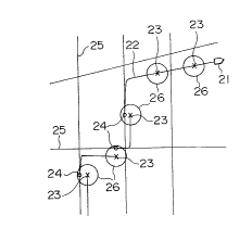
In Fig. 2, there are shown: a travelling locus
22 of a vehicle 21; positional points 23 where the on-
vehicle position and azimuth correcting means 17 has
attempted to make corrections; positional points 24 where
corrections have been made by comparing the on-vehicle
positions and azimuths with the on-road positions and
azimuths gathered by the road data gathering means 15;
road data 25 gathered by the road data gathering means
15; and ranges 26 where respective differences between
the on-road position and the on-vehicle position and
between the on-road azimuth and the on-vehicle azimuth
are smaller than the above-described determined values,
respectively.
Next, the straight running detecting means 7
detects whether the vehicle is travelling on a straight
road or not. A straight running condition of the vehicle
is decided to be the case if an integral value of the
angular velocity obtained by the angular velocity detect-
-- 11 --
1 ing means 4 from the straight running starting positionis equal to or smaller than a prede-termined value and
further an integral value of angular velocities detected
within another shorter travelling section, which is
separately determined, is equal to or smaller than
another predetermined value.
While the vehicle is running straightly,
firstly data sent from the GPS receiver 1 are analyzed,
and a reception position, where the GPS receiver 1 has
received the data (this reception position is a measure-
ment position, namely, a position where the GPS has
decided that the receiver is present, but this reception
position may be different from a position where the
vehicle is actually travelling), is utilized by the GPS
measurement position computing means 2 to compute a
longitude and a latitude of the reception position; both
the combination and the number of satellites used in this
measurement are determined by the GPS used satellite
det~ ining means 12; and then the deterioration rate of
the measurement position deter~ining precision such as
HDOP (Horizontal Dilution of Precision) or the like
estimated by the actual GPS satellite arrangement is
determined by the GPS precision deterioration rate
dete_ ining means 13.
Every time a measurement position is computed
by the GPS measurement position computing means 2, the
GPS longitude line computing means 8 computes the
following items (a) to (d).
- 12 -
?, ~
1 (a) an integral value of the longitudes from the
longitude of the straight running starting position of
the vehicle up to the longitude of each measurement
position.
(b) an integral value of the moving distances from
the straight running starting position of the vehicle up
to each measurement position.
(c) An integral value of the values each of which
is obtained by (the longitude at each measurement posi-
tion) X (the moving distance from the straight running
starting position up to each measurement position).
(d) An integral value of the values each of which
is obtained by squaring the moving distance from the
straight running starting position of the vehicle up to
each measurement position.
Similarly, the GPS latitude line computing
means 9 computes the following items (e) to (f).
(e) An integral value of the latitudes from the
latitude of the straight running starting position of the
vehicle up to the latitude of each measurement position.
(f) An integral value of the moving distances from
the straight running starting position of the vehicle up
to each measurement position.
(g) An integral value of the values each of which
is obtained by (the latitude at each measurement posi-
tion) X (the moving distance from the straight running
starting position up to each measurement position).
(h) An integral value of the values each of which
3 ! ~
1 is obtained by squaring the moving distance from the
straight running starting position of the vehicle up to
each measurement position.
Here, it should be noted that, when the preci-
sion deterioration rate determined by the GPS precisiondeterioration rate deter~; n; ng means 13 is equal to or
higher than a predetermined value (namely, the position
deterr;n;ng precision is deteriorated), this measurement
position is not used in the computation of the above-
mentioned integral values.
Also, when a difference between a straightdistance between a first position, which is computed
based on the longitude and latitude of the preceding GPS
measurement position, and a second position, which is
computed base on the longitude and latitude of the pre-
sent GPS measurement position, and a moving distance
between the above-mentioned two positions obtained by the
moving distance detecting means 6 is equal to or greater
than a predetermined value, the position computed based
on the longitude and latitude of the present GPS measure-
ment position is not used in the computation of the
above-mentioned integral values.
Furthermore, when a difference between a
distance between a position, which is computed based on
the longitude and latitude obtained by the preceding GPS
measurement at the straight running starting position,
and a position, which is computed based on the longitude
and latitude obtained by the present GPS measurement
- 14 -
S~ r,3
1 position, and a moving distance between the above-
mentioned two positions obtained by the moving distance
detecting means 6 is equal to or greater than a pre-
determined value, this value is not used in the compu-
tation of the above-mentioned integral values, assuming
that an error of the present GPS measurement position is
great.
As a result, a GPS measurement, whose
measurement precision is temporarily deteriorated due to
reflection of electromagnetic waves, etc., is excluded,
and the position and azimuth modification in the GPS
system can be performed with high precision.
In Fig. 3, there are shown a travelling locus
32 of a vehicle 31; a measurement position 33 measured by
the GPS system with high precision; a measurement posi-
tion 34 measured by the GPS system with deteriorated
precision; a position 35 where the vehicle 31 is actually
travelling, though this position corresponds to the
above-described-position 34 measured by the GPS system; a
distance 36 obtained based on the longitudes and lati-
tudes of the two GPS measurement positions; and a moving
distance 37 between the two GPS measurement positions
obtained by the moving distance detecting means 6.
Then, when either the combination or the number
of satellites used in the measurement, which satellites
have been determined by the GPS used satellite deter-
mining means 12, is different from either the combination
or the number of satellites used in the previous GPS
- 15 -
3 ' ~
1 measurements, respectively, and also when a predetermined
number of GPS measurement positions have occurred, which
GPS measurement positions have been unable to be used in
the computation of the integral values in view of the
above-described conditions, all of the integral values
computed so f ar are set to zero, and the computation of
integral values is restarted with this position being
used as a starting position where a new measurement of
the straight running of the vehicle is to be started.
As a result, since only the measurement posi-
tions, which use a selected combination of satellites,
are utilized as a basis of computation, even when the
measurement precision changes due to a variation in the
combination of satellites used in the measurement, it is
possible to prevent an error from occurring when the
measurement is carried out by using a different combina-
tion of satellites, so that the position and azimuth
modification by the GPS system can be carried out with
high precision.
Furthermore, when the number of times of
measurement by the GPS system is equal to or greater than
a preset number of times, and also the moving distance
from the straight running starting position is equal to
or longer than a preset distance, the GPS longitude
computing means 8 and the GPS latitude computing means 9
operate respectively to use the integral values of the
longitudes and latitudes, which have been computed so
far, thereby to obtain a regression line by regressing
- 16 -
~ fJ
1 the longitudes of the GPS measurement positions during
the straight running of the vehicle to the moving
distance from the straight running starting position and
a regression line by regressing the latitudes of the GPS
measurement positions during the straight running of the
vehicle to the moving distance from the straight running
starting position. In this case, the frequency and
precision of the modification of the on-vehicle position
and azimuth may be optimized by varying the above-
described preset number of times of the GPS measurementand the above-described preset distance from the straight
running starting position.
If the respective values of the preset number
of times and the preset distance are increased, the
precision is elevated, while the modification frequency
is decreased. Conversely, if the respective values of
the preset number of times and the preset distance are
decreased, the modification frequency is increased, while
the precision is deteriorated.
Assuming that the symbol ~y' indicates either
the longitude or latitude, and the symbol ~x" denotes a
moving distance from the straight running starting
position, the above-mentioned formula of the regression
lines is represented by
y = ax + b
25 where the coefficients "a" and "b" are given by the
1 following equations (1) and (2)
n n n
i-l iYi (i~lXi) . (i~lYi)
a = .... (1)
n ~ x~ Xi)2
i=l i=l
n n
i-1 i-1 i
b = - a- .... (2)
n n
where n: the number of times of the GPS measurement
during the straight running;
~y: an integral value of either the longitude or
the latitude at respective measurement
positions;
~x: an integral value of the moving distance from
the straight running starting position;
~xy: an integral value of a product of the
longitude or the latitude and the moving
distance from the straight running starting
position; and
~x2: an integral value of a square of the moving
distance from the straight running starting
position.
Fig. 4 represents a regression line 41 of
either the longitude or the latitude; a point 42 which
- 18 -
r 9
l indicates the relation between the moving distance from
the straight running starting position of the vehicle in
the GPS measurement and the long:itude or the latitude; an
on-vehicle position and azimuth modifying position 43;
and a straight running section 44.
Thus, when each of the GPS longitude line and
the GPS latitude line is obtained in the form of a
regression line, the GPS on-vehicle azimuth modifying
means 10 computes a vehicle azimuth during the straight
running of the vehicle on the basis of an inclination of
the longitude versus latitude line during the straight
running of the vehicle, which inclination is obtained
from an inclination of the GPS longitude line and an
inclination of the GPS latitude line, and thereby modi-
fies the on-vehicle azimuth obtained by the on-vehicle
position and azimuth computing means 16. The GPS on-
vehicle position modifying means 11 computes a vehicle
position by applying a straight running moving distance
from the straight running starting position of the
vehicle up to the measurement position to the GPS
longitude line and the GPS latitude line, and thereby
modifies the on-vehicle position obtained by the on-
vehicle position and azimuth computing means 16.
Here, if a moving distance from the straight
running starting position is shorter than a predetermined
value, in spite that the number of times of the GPS
measurements is equal to or greater than a predetermined
value, the GPS on-vehicle position correcting means 11
-- 19 --
l computes a vehicle position by applying the straight
running moving distance from the straight running start-
ing position up to the present measurement position to
the GPS longitude line and the GPS latitude line, and
thereby modifies the on-vehicle position obtained by the
on-vehicle position and azimuth computing means 16.
However, the GPS on-vehicle azimuth modifying means 10
does not perform a modification of ~he on-vehicle
azimuth. As a result, an azimuth modification with
deteriorated precision can be avoided.
When a moving distance from the straight run-
ning starting position, which moving distance has been
detected by the moving distance detecting means 6, is
equal to zero, in spite that the number of times of the
GPS measurements is equal to or greater than a preset
value, the GPS longitude line computing means 8 and the
GPS latitude line computing means 9 compute respective
average values of the longitudes and latitudes obtained
by the GPS measurements performed at respective measure-
ment positions, whereby a vehicle position is obtainedbased on the respective average values of the longitudes
and latitudes, and then the GPS on-vehicle position
modifying means 11 modifies an on-vehicle position
computed by the on-vehicle position and azimuth computing
means 16 by using the vehicle position thus obtained.
However, if the number of times of corrections
recorded in the correction times recording means 18 is
equal to or greater than a preset value, no modification
- 20 -
r~ ~
1 is carried out by the GPS on-vehicle azimuth modifying
means 10 and the GPS on-vehicle position modifying means
11. As a result, it can be prevented that an on-vehicle
position is modified to indicate an incorrect on-road-map
position due to a GPS measureme..c of deteriorated preci-
sion, in spite that the vehic~e is travelling at a
correct position on the road map.
Further, when the GPS on-vehicle azimuth
modifying means 10 performs a modification of an on-
vehicle azimuth, it may be possible to use:
(a) a longitude and a latitude which are obtainedby applying a moving distance from the straight running
starting position of the vehicle but having a zero value
to the GPS longitude line and the GPS latitude line,
respectively, that is, the longitude and the latitude at
the stragiht running starting position of the vehicle;
and
(b) a longitude and a latitude which are obtained
by applying a moving distance from the straight running
starting position of the vehicle up to the present
measurement position to the GPS longitude line and the
GPS latitude line, respectively, to thereby obtain a
vehicle azimuth of the present measurement position as
viewed from the straight running starting position.
Similarly, when a position and an azimuth of
the vehicle obtained by the GPS measurement are used, as
they are, to perform modifications of an on-vehicle
position and an on-vehicle azimuth, respectively, no
- 21 -
2'~3~
1 modification is carried out, if the number of times of
corrections recorded in the correction times recording
means 18 is equal to or greater than a preset value. As
a result, it can be prevented that an on-vehicle position
and an on-vehicle azimuth are modified to have incorrect
values, respectively, by the use of information of
deteriorated precision, in spite that the vehicle is
travelling at a correct position on the road map.
As explained above, in accordance with the
first preferred embodiment, even when there is no oppor-
tunity of modifying the on-vehicle position and on-
vehicle azimuth over a long travelling distance, it is
possible to determine the vehicle position and azimuth
with elevated precision by utilizing the GPS system.
Fig. 5 is a block diagram showing a second
embodiment of the present invention. In Fig. 5, refer-
ence numeral 51 denotes vehicle position and azimuth
information gathering means for gatering information on
positions and azimuths of a vehicle from outside of the
vehicle; and reference nuemral 52 indicates on-vehicle
position and azimuth modifying means for modifying an
on-vehicle position and an on-vehicle azimuth based on
the information on the position and the azimuth of the
vehicle gathered by the vehicle position and azimuth
information gathering means 51 and also based on the
number of times of corrections recorded in the correction
times recording means 18. Since the remaining component
elements of the second embodiment are similar to those of
- 22 -
~72~ 6 9
l the first em~odiment, an explanation thereof is omitted.
Then, a description will be made of an opera-
tion of the second embodiment. The vehicle position and
azimuth computing apparatus of the second embodiment
performs a similar operation by substituting the position
and azimuth information of the vehicle gathered by the
vehicle position and azimuth information gathering means
51 for the longitude and latitude information utilized in
the first embodiment. Also, in this second embodiment,
when the number of times of corrections reocrded in the
correction times recording means 18 is equal to or
greater than a preset value, no modification is carried
out based on the vehicle position information and the
vehicle azimuth information gathered by the vehicle
position and azimuth information gathering means 51. As
a result, the second embodiment has an advantage of
preventing an on-vehicle position and an on-vehicle
azimuth from being modified to indicate an incorrect
position and an incorrect azimuth, respectively, based on
the vehicle position and azimuth informatin of deterio-
rated precision gathered from outside of the vehicle, in
spite that the vehicle is travelling at a correct posi-
tion on the road map.
- 23 -