Note : Les descriptions sont présentées dans la langue officielle dans laquelle elles ont été soumises.
208118~
1 BACKGROUND OF THE lNv~NlION
FIELD OF THE INVENTION
The present invention relates to a navigation
system installed in a vehicle which displays the position
and direction of the vehicle, map information of an area
around the vehicle, etc., and, more particularly, to a
navigation system which calculates coefficients of
devices, such as a velocity sensor, for obtaining a
travel distance based on the rotation of the tires of the
vehicles.
DESCRIPTION OF THE RELATED ART
A known vehicle navigation system obtains
travel distances and rotational angles by using a
velocity sensor or a distance sensor and an angle sensor
and, based on the travel distances and rotational angles,
discovers the position and direction of the vehicle. If
necessary, the vehicle's positional data is corrected by
comparing a travel path of the vehicle with map data.
Further, if a GPS (Global Positioning System), which
measures the absolute position of a vehicle, is avail-
able, the position measured by the navigation system can
be corrected so as to equal the position measured by the
GPS (GPS position).
This known navigation system obtains a travel
distance by the velocity sensor detecting pulses or the
2081185
1 like outputted in accordance with the rotations of the
tires of the vehicle and by the number of the detected
pulses multiplied by a coefficient which is used for
converting a number of pulses to a distance, that is, a
coefficient of the velocity sensor.
The GPS cannot always fully function; for
example, a sufficient number of satellites are usually
not available for positioning in the vicinity of tall
buildings or high mountains. Therefore, in the above-
described known navigation apparatus, in order to performsufficiently precise positioning even in such areas where
GPS is not usable, the positioning precision of dead
reckoning performed by using a velocity sensor and an
angular velocity sensor must be substantially high. In
order to maintain high positioning precision of the dead
reckoning system, a user must correct the coefficient of
the velocity sensor if the size of tires changes because
of, e.g., age deterioration or pressure changes in the
tires, or because the tires are changed. However, a
change in this coefficient greatly affects the position-
ing precision, and it is not easy for the user to perform
such a delicate correction.
To avoid this problem, a method has been
developed in which the velocity sensor coefficient is
automatically corrected by using map data, more
specifically, by comparing the length of a travel path of
a vehicle which is obtained on the basis of various
positions of the vehicles calculated by the navigation
2o8ll85
1 system with the corresponding distance separately
obtained from the road data of the map data. Fig. 1
illustrates this method. While the length of a travel
path 503 between two corners 501 and 502 is being
compared with the distance 504 therebetween obtained from
road data, the velocity sensor coefficient is automati-
cally corrected so that the travel path length 503
becomes equal to the distance 504 based on road data.
However, in this method, positioning precision
sometimes deteriorates. As shown in Fig. 2, if there are
two streets 602, 603 which are close to each other in the
vicinity of a corner 601 and have similar appearances and
directions, one street may be mistaken for the other. If
the street 603 is mistaken for the street 602 on a map
when the velocity sensor coefficient is going to be
automatically corrected, the navigation system calculates
such a velocity sensor coefficient that a travel path
length 604 becomes equal to the distance 605 to the
street 603 instead of the distance to the street 602,
thus increasing any error in the velocity sensor
coefficient. Therefore, the positioning precision is
deteriorated.
Further, Japanese Patent Unex~rined Publication
No. 2-212714 disclcses a method in which a ratio is
obtained between an integrated travel distance of a
travelling object which is obtained by the GPS navigation
method using satellites and another integrated travel
distance which is obtained by an independent navigation
2o8ll85
` -
1 method using a distance sensor or the like, and the
output of a distance sensor is corrected by using this
ratio as a correction parameter.
In this method, however, a travel distance
obtained on the basis of outputs of the sensor is likely
to deviate from the actual travel distance if the
distance between positioning points is great and the
travel path has curves. Thus, the method will likely
fail to precisely correct sensor outputs.
10 SUMMARY OF THE lNV~;N'l'ION
The present invention is intended to solve the
above-described problems of the known art. Accordingly,
an object of the present invention is to provide a
vehicle navigation system which obtains precise velocity
sensor coefficients which is used to multiply the outputs
of a velocity sensor and thus achieves high precision in
position measurement.
To achieve the above object, a navigation
system according to the present invention automatically
calculates sensor coefficients on the basis of either the
ratio between a distance between two positions of the
vehicle obtained from the outside and a linear travel
distance obtained on the basis of the signals outputted
by the sensor during the linear travel of the vehicle
between the two positions of the vehicle, or the ratio
between the distance between the two positions of the
vehicle obtained from the outside and a linear distance
~ 2081185
1 between two estimated positions calculated respectively
when one and the other of thé two positions are obtained
from the outside.
Therefore, according to the present invention,
the velocity sensor coefficient is automatically
corrected if the size of the tires changes due to age
deterioration or pressure changes in the tire, or because
the tires are changed. Further, the system of this
invention can perform such correction without using map
data, thus eliminating errors caused by the use of the
map data.
Because a linear distance between estimated
positions calculated simultaneously when positional data
is obtained from the outside is used to obtain the
distance ratio, the conditions of the travel path, such
as curves thereof, between the estimated positions do not
affect position measurement, thus achieving highly
precise correction of the velocity sensor coefficient.
BRIEF DESCRIPTION OF THE DRAWINGS
Fig. 1 illustrates the operation for calculat-
ing coefficients of a velocity sensor in a conventional
navigation system.
Fig. 2 illustrates problems of the operation
illustrated in Fig. 1.
Fig. 3 is a block diagram of a navigation
system according to the first embodiment of the present
invention.
2081185
1 Fig. 4 illustrates the operation of the naviga-
tion system illustrated in Fig. 3.
Fig. 5 is a block diagram of a navigation
system according to the second embodiment of the present
invention.
Fig. 6 illustrates the operation of the naviga-
tion system illustrated in Fig. 5.
DESCRIPTION OF THE PREFERRED EMBODIMENTS
A navigation system according to the first
embodiment of the present invention is illustrated in
Fig. 3. In the figure, a velocity sensor 101 detects the
velocity of a vehicle in which the navigation system is
installed. More specifically, the velocity sensor 101
outputs a pulse every time the vehicle has travelled a
predetermined distance. An angular velocity detector 102
detects angular velocity of the vehicle during travelling
of the vehicle. Instead of the angular sensor 102, other
types of direction sensors, such as a geomagnetic sensor,
may be used. Japanese Patent Unexamined Publication No.
63-262518 and others disclose an system in which a
velocity sensor and a geomagnetic sensor are used to
estimate the position of a vehicle. A GPS receiver 103
receives radio waves from a plurality of GPS satellites
and outputs data on the position where the radio waves
are received (referred to as the "GPS position" herein-
after). Such GPS receivers are described in detail in
Nippon Musen Gihou, No. 24, pp. 16 to 23, 1986. An
2081185
1 estimated position and direction calculating means 104
calculates current position and direction of the vehicle
(current position and direction of the vehicle thus
obtained are referred to as an "estimated position" and
an ~estimated direction~ hereinafter) on the basis of
signals outputted by the velocity sensor 101 and the
angular velocity sensor 102. A linear travel detecting
means 105 detects linear travel of the vehicle, on the
basis of the estimated position and direction. A
velocity sensor coefficient calculating means 106
calculates a velocity sensor coefficient on the basis of
a ratio between a distance between two positions measured
by the GPS (Global Positioning System) during the linear
travel of the vehicle and a distance (a linear travel
distance) obtained on the basis of output values which
the velocity sensor 101 generates between when the first
position of the two GPS positions is measured and when
the second GPS position is measured.
The operation of the navigation system accord-
ing to the first embodiment of the present invention will
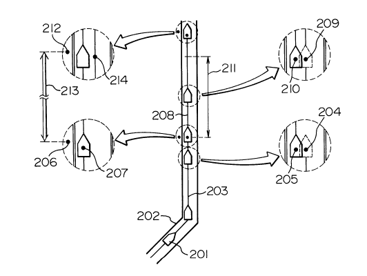
be described with reference to Fig. 4. In Fig. 4, a
vehicle 201 travels on a road 202. At a point 204, it is
found that the vehicle 201 has linearly travelled a
predetermined distance or longer on a travel path 203.
The navigation system corrects the estimated position 204
so that it coincides with a position 205 on which the
vehicle is supposed to travel. The state of linear
travelling is usually detected by discovering that
~ 208118S
1 changes in the travel direction of the vehicle remain
within a predetermined angle over a predetermined
distance or greater. This is an easy method for a
vehicle navigation system, and the present invention uses
this method.
A point 206 is a first GPS position measured by
the GPS during linear travel of the vehicle. A point 207
is an estimated position of the vehicle calculated at a
time when the first GPS position 206 is measured. At the
point 207, the navigation system starts integration
output values of the velocity sensor 101, that is,
integration of values obtained by multiplying the output
values of the velocity sensor 101, i.e., the number of
pulses, by a coefficient. Then, at a point 209 where the
linear travel detecting means 105 detects a linear travel
of a predetermined distance or greater 208, the naviga-
tion system corrects the estimated position 209 so that
it coincides with a position 210 on which the vehicle is
supposed to travel. Because a vehicle must travel a
predetermined distance or greater in order to calculate a
velocity sensor coefficient, the estimated position 209
before correction is stored as well and renewed as an
estimated position which is used to calculate a velocity
sensor coefficient.
Then, when the vehicle has linearly traveled a
predetermined distance 211 or greater and a second GPS
position 212 is measured, the distance 213 between the
two GPS positions 206 and 212 is obtained. Further,
2081185
1 obtained is an estimated linear travel distance which is
an integration on the basis of output values of the
velocity sensor between the estimated position 207
calculated when the first GPS position 206 is measured
~ 5 and an estimated position 214 calculated on a travel path
which has not been corrected by the navigation system,
when the second GPS position 212 is measured. Next, a
value is obtained by dividing the distance between the
GPS positions by the estimated linear travel distance and
defined as a new velocity sensor coefficient (see
Expression (1)).
kp18(n) = dlgp8/dlpl8 ......... (1)
where: kp18(n) is a new velocity sensor coefficient;
dlgp8 is a distance between two GPS positions; and
dlp18 is a distance obtained using values
outputted by the velocity sensor during a period between
measurements of the two GPS positions.
Instead of directly calculating a velocity
sensor coefficient from a distance between GPS positions
and an estimated travel distance, a new velocity sensor
coefficient may be calculated by multiplying the ratio
between these two distances by the previous velocity
sensor coefficient as follows:
kpl8(n) = kpl8(n-1) x dlgp8/dlpl8 -- (2)
where: kpl8(n) is a new velocity sensor coefficient;
kpl8(n-1) is the previous velocity sensor
2081185 coefficient;
dlgp8 is a distance between two GPS positions; and
dlpl8 is a distance obtained using values
outputted by the velocity sensor during a period between
measurements of the two GPS positions.
Further, instead of immediately shifting to a
new velocity sensor coefficient, the previous velocity
sensor coefficient may be gradually converged to the
target value so as to smooth changes of the coefficient
due to rapid acceleration and deceleration of the
vehicle, as follows:
kpl8(n) = kpl8(n-l ) x ( 1 - a + a x dlgp8/dlpl8)
..... (3)
where: kpl8(n) is a new velocity sensor coefficient;
kpl8(n-l) is the previous velocity sensor
coefficient;
dlgp8 is a distance between two GPS positions;
dlpl8 is a distance obtained using values
outputted by the velocity sensor during a period between
0 measurements of the two GPS positions; and
a is a coefficient which determines the rate of
convergence to the target value (0 S a S 1).
As described above, this embodiment, using the
GPS instead of map data, automatically calculates a new
velocity sensor coefficient by, for example, obtaining a
ratio of a distance between two GPS positions in a linear
-- 10 --
2081185
1 travel section to a distance obtained by using the
velocity sensor when the vehicle has linearly travelled
in a period between measurements of the two GPS posi-
tions, or multiplying such a ratio by the previous
velocity sensor coefficient., Therefore, a user of the
navigation system does not need to correct velocity
sensor coefficients. Further, the velocity sensor
coefficient is automatically corrected without an error
caused by misreading of map data. Still further, the
velocity sensor coefficient is precisely corrected even
if a travel path includes a curve.
Another embodiment which can correct the
velocity sensor coefficient even when the vehicle is not
linearly travelling will be described with reference to
Figs. 5 and 6. Fig. 5 is a block diagram of such an
embodiment, and Fig. 6 illustrates the operation thereof.
Fig. 5 shows: a velocity sensor 101; an
angular velocity sensor 102; a GPS receiver 103;
estimated position calculating means 104 for calculating
estimated position and direction of the vehicle by using
the velocity and angular velocity sensors 101, 102; and
velocity sensor coefficient calculating means 107 for
obtaining a new velocity sensor coefficient by multiply-
ing a ratio ~f a distance between two GPS positions
measured by using the GPS to a distance between an
estimated position of the vehicle obtained when the first
one of the two GPS positions is measured and another
estimated position obtained when the second GPS position
2081185
1 is measured, by the previous velocity sensor coefficient.
Referring to Fig. 6, a vehicle 401 travels
along a road 402. In this embodiment, detection of the
linear travel of the vehicle is not required. First, a
first GPS position 403 measured by using the GPS and an
estimated position 404 of the vehicle calculated when the
first GPS position 403 is measured are stored. Then, a
distance 407 from the first GPS position 403 to a second
GPS position 406 which is farther than a predetermined
distance 405 from the first GPS position 403 is obtained.
Also, a linear distance 409 from the estimated position
404 to another estimated position 408 which is calculated
without correction by the navigation system when the
second GPS position 406 is measured. Then, the ratio
between the distance 407 and the linear distance 408 is
calculated and multiplied by the previous velocity sensor
coefficient to obtain a new velocity sensor coefficient
(see the following expression (4)).
kpl8(n) = kpl8(n-l) x dlgp8/d2pl8 ---- (4)
0 where: kpl8(n) is a new velocity sensor coefficient;
kp18(n-l) is the previous velocity sensor
coefficient;
dlgl8 is a distance between the GPS positions; and
d2pl8 is a linear distance obtained using values
outputted by the velocity sensor during a period between
measurements of the two GPS positions.
Further, instead of immediately shifting to a
208118~
1 new velocity sensor coefficient, the previous velocity
sensor coefficient may be gradually converged to the
target value so as to smooth changes of the coefficient
due to rapid acceleration and deceleration of the
vehicle, as follows:
kpl8(n) = kpl8(n-1) x (1 - a + a x dl~p8/d2pl8 )
..... (5)
where: kpl8(n) is a new velocity sensor coefficient;
kpl8(n-l) is the previous velocity sensor
coefficient;
dlgp~ is a distance between two GPS positions;
d2pl8 is a linear distance obtained using values
outputted by the velocity sensor during a period between
measurements of the two GPS positions; and
a is a coefficient which determines the rate of
convergence to the target value (0 S a S 1 ) .
As described above, this embodiment, using the
GPS instead of map data, automatically calculates a new
velocity sensor coefficient by, for example, obt~ining a
ratio of a distance between two GPS positions to a linear
distance between two estimated positions calculated when
the respective GPS positions are respectively measured,
or multiplying such a ratio by the previous velocity
sensor coefficient. Therefore, a user of the navigation
system does not need to correct velocity sensor coeffi-
cients directly. Further, the velocity sensor coeffi-
cient is automatically corrected without an error caused
- 13 -
2081185
1 by misreading of map data. Still further, because a
linear distance between estimated positions of the
vehicle calculated when the respective GPS positions are
measured is used to obtain the distance ratio, the
velocity sensor coefficient is precisely corrected no
matter what travel path the vehicle has taken between the
estimated positions.
A "GPS position" as described in the above two
embodiments is not necessarily positional data directly
outputted by the GPS receiver. For example, for the
purpose of stabilization, a "GPS position" may be a
central position of a predetermined number of plural
positional data or plural positional data obtained in a
period of a predetermined length (such as a mean position
(centroid) of all these positions, or a position which
provides the minimum sum of squares of distances there-
from to all the individual positions).
Though the above embodiments obtain positional
data from the outside by using the GPS, positional data
may be obtained from stations which transmit positional
data, such as sign posts, as described in Japanese Patent
Unex~rined Publication No. 62-279720 and Japanese Utility
Model Unex~mi~ed Publication No. 2-98533, providing
substantially the same effects.
As described above in connection with the
preferred embodiments, the navigation system of the
present invention automatically correct the velocity
sensor coefficient which changes due to age deterioration
- 14 -
2081185
1 or the like, this system eliminates the néed for a user
to correct the velocity coefficient and, further,
eliminates errors caused by correction of the velocity
sensor coefficient on the basis of map data, thus
achieving high-precision position measurement.