Note : Les descriptions sont présentées dans la langue officielle dans laquelle elles ont été soumises.
214~347
BAYESIAN SEQUENTIAL INDICATOR SIMULATION OF LITHOLOGY
FROM SEISMIC DATA
BACKGROUND OF THE INVENTION
Field of the Invention
This invention is concerned with a method for
generating subsurface models of lithology using a Monte
Carlo procedure. The lithologic models are obtained by
combining seismic attribute records collected along an
array of seismic stations that are deployed over an area
of interest and from lithology observations in boreholes
located within or close to the area covered by the
seismic survey.
Discussion of Related Art
Although the art of seismic exploration is well
known, those principles that are germane to this
invention will be reviewed briefly. An acoustic
wavefield is generated at or near the surface of the
earth to insonify the underlying earth layers or strata.
The wavefield is reflected in turn from each subsurface
stratum whence the wavefield returns to the surface. The
returning reflected wavefield manifests itself as a
periodic mechanical motion of the earth's surface that
is detected by suitable sensors. The sensors convert the
mechanical motion to electrical signals which are
recorded on an archival storage medium such as time-
scale recordings in analog or digital format as desired
by the investigator.
Of the many quantities that may be gleaned from the
recorded seismic data, two are of particular interest,
namely: Reflection travel time and reflection amplitude.
Reflection travel time is a measure of the depth of the
respective strata. Reflection amplitude depends upon the
reflectivity coefficient at the interface between two
--1--
- 214~'~47
strata. The reflectivity coefficient depends upon the
difference in acoustic impedance across the interface.
The acoustic impedance of a stratum is defined by the
product of the acoustic velocity and the density of that
rock layer. Impedance is measured in units of meters per
second per gram per cubic centimeter.
To be of use quantitatively, the observed
reflection amplitude must be corrected for spherical
spreading, instrumental artifacts and other predictable
effects to provide true amplitude measurements. The
resulting true amplitudes may used to calculate the
acoustic impedances of the respective strata.
It can be demonstrated that limited ranges of
acoustic impedance values can be associated with
particular rock types such as, by way of example but not
by way of limitation, sand, shale and dolomite. However,
because of seismic and lithologic noise, there is
overlap between the ranges of impedance values
attributable to each lithoclass. Thus, any one
calculation of acoustic impedance is at best only an
estimate of a particular lithoclass, the estimate being
subject to statistical uncertainty.
In the course of geoexploration, control points may
be established by boreholes, often quite widely
separated, that penetrate strata of interest. At such
sparse control points, the seismic observations may be
calibrated by comparison of selected seismic attributes
with a study of the texture and composition of the
target strata. The desideratum of a seismic survey line,
having relatively closely-spaced observation stations
that are distributed between the sparse control points,
is to estimate the continuity of one or more target
lithologic horizons between the control points.
U.S. patent 4,926,394 issued May 15, 1990 to
Philippe M. Doyen and assigned to the assignee of this
invention, teaches a type of Monte Carlo statistical
2144347
method for estimating a variation in rock type or
texture, that is, the change in lithology along a given
stratum or a related grouping of strata within a
selected geologic formation. The estimates are based on
seismic data gathered over an array of survey lines that
coincide with sparsely-spaced control points such as
boreholes. This is a type of maximum a posteriori
estimation technique. It suffers from the disadvantages
that a) it is computer intensive; b) it is sometimes
difficult to guarantee convergence of the iterative
optimization procedure used in the technique; c) it is
difficult to specify the required lithology transitlon
statistics.
A number of methods have been suggested that are
based on image enhancement techniques such as discussed
in the paper The Mathematical Generation of Reservoir
Geology by C. L. Farmer, presented July, 1989 at the
IMA/SPE European Conference on the Mathematics of Oil
Recovery.
Another technique involves Indicator Kriging such
as is discussed in a paper entitled MapPing by Simple
Indicator Kriqing by Andrew R. Solow in Mathematical
Geology, v. 18, no. 3, 1985. That method is a
generalized linear regression technique to calculate a
lithoclass probability distribution function at one
location from lithoclass data at other locations in the
pertinent space of interest. The method requires the
specification of a spatial correlation model which may
be difficult to infer from sparse borehole control.
Simple Indicator Kriging does not allow direct
integration of seismic information. Also the models are
poorly defined if well control is sparse. The term
"indicator" implies that the lithoclasses are discrete
variables such as sand or shale rather than continuous
variables such as permeability.
'- 21443~7
There is a need for a method that will generate
simulated models of subsurface lithology by combining
seismic attribute data and lithologic observations in
boreholes. The method should be easy to generalize in
the presence of multivariate environments.
SUMMARY OF THE INVENTION
An array of seismic stations having a predetermined
spacing is emplaced over a region of interest that may
include a paucity of control points corresponding to
borehole locations. The data collected at the respective
seismic stations include seismic attributes that are
correlatable with the type and texture of the subsurface
rock layers. The respective seismic stations define an
array of pixels having dimensions comparable to the
preselected station spacing.
The method of this invention includes the steps of
randomly selecting a pixel from the array. Using
Indicator Kriging, estimates the prior probability
distribution of the lithoclasses for the selected pixel,
given the lithologic data at the neighboring pixels.
Based upon the seismic and lithologic data as observed
at the control points, determine the likelihood of
occurrence of each lithoclass at the chosen pixel.
Determine the lithoclass posterior probability
distribution from the product of the prior probability
distribution and the likelihood function. Draw a
simulated lithoclass value at the selected pixel by
randomly sampling from the posterior distribution and
consider the simulated value as an additional control
point in the simulation process. Repeat the steps of
selecting a pixel, calculating the posterior
distribution and sampling from the posterior
distribution until lithoclass values are simulated for
all pixels of the array.
214~347
In an aspect of this invention, the likelihood
function is derived from the lithoclass-conditional
probability distributions of the seismic attributes.
In an aspect of this invention, the selected
seismic attribute is acoustic impedance as derived from
normalized seismic reflection amplitudes.
BRIEF DESCRIPTION OF THE DRAWINGS
The novel features which are believed to be
characteristic of the invention, both as to organization
and methods of operation, together with the objects and
advantages thereof, will be better understood from the
following detailed description and the drawings wherein
the invention is illustrated by way of example for the
purpose of illustration and description only and are not
intended as a definition of the limits of the invention:
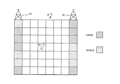
FIGURE 1 represents an array of pixels positioned
between two borehole control points;
FIGURE 2 exhibits a random selection of pixels,
xi, for study;
FIGURE 3 is the prior sand/shale probability
distribution for pixel X2l;
FIGURE 4 shows the input data used for Indicator
Kriging to determine the prior sand/shale probability
distribution;
FIGURE 5 shows the conditional probability
distribution of the seismic attribute z for two
lithoclasses;
FIGURE 6 illustrates the combination of the
likelihood function and the prior distribution to yield
the posterior distribution;
FIGURE 7 shows the results of applying the
operation of FIGURE 6 to pixel X2l of FIGURE 4;
FIGURES 8A-8C exhibit three simulations of the
lithoclass at selected pixels; and
--5--
21~347
FIGURE 9 is the final estimate from among the three
estimates of FIGURES 8A-8C.
DETAILED DESCRIPTION OF THE PREFERRED EMBODIMENT
Figure 1 represents a vertical slice or section 8
of the earth between two boreholes 10 and 12 at opposite
ends of the slice. The section has been divided into an
array of pixels, i, whose dimensions are arbitrary but
preferably are commensurate with the spacing of a
plurality of seismic observation stations (not shown)
that are distributed between boreholes 10 and 12.
Associated with each pixel, there is a lithoclass xi,
here assumed to be a discrete binary variable for
simplicity but not limited thereto, such as sand and
shale. From well logs, the known lithoclasses for each
pixel beneath the boreholes 10 and 12 are shown as
diagonal shading for sand and horizontal dashed lines
for shale. Boreholes 10 and 12 provide control points
for correlating some seismic attribute Zi, such as trace
amplitude or inverted acoustic impedance, with a
particular lithoclass xi. The xi assume values of 1 for
sand and 0 for shale. It is desired to simulate a
subsurface model of the lithology that is consistent
with both the well data and the seismic data. It is
obvious that a plurality of similar vertical sections
may be assembled over an area to provide three-
dimensional coverage for the area of interest.
With reference to Figure 2, we begin by randomly
selecting a pixel such as x2l that has not yet been
simulated. Other pixels that had been previously visited
in random order are indicated by the arrows. The local
sand/shale distribution is estimated by use of Indicator
Kriging according to the formulations
P IK (i) = p (Xi = 1 ¦ Xl~ Xi-l) (l)
pshale ( i ) = 1 ~ p IK ( i ) ( 2)
--6--
2144~4~
For the 2lst pixel, select x21 ~ (sand/shale~ at random
from the Kriging-derived sand/shale probability
distribution as shown in Figure 3. The complete
simulation process amounts to repeating the calculations
and sampling of the sand/shale probability distributions
at all pixels of the model, following a random pixel
visitation sequence.
From a practical viewpoint, the sand/shale
probabilities are calculated at each pixel along the
random path as linear combinations of the observed data
and any previously simulated values lying within a local
search area as shown in Figure 4. Thus., we want to
estimate the most likely lithoclass for pixel 21 given
knowledge of the nearby lithoclasses in pixels 4, 5, 6
and 18. Remembering the discrete binary values that were
assigned for sand and shale respectively, the sand
probability may be evaluated from
P Il~ ( 2 1 ) = ( W4 ~ 1 ) + ( W5 ~ O ) + ( W6 ~ ~ ) + ( W18 ~ 1 ) +W3 ~ ( 3)
2 0 The bias constant wO is determined from
wO = (1 ~wi} * ~ (4)
where ~sand is the proportion of sand in the gross rock
volume.
The data weights wi to be applied to each pixel are
determined from the condition that the lithology
prediction error is to be minimized in a least mean
square sense. The data weights wi are obtained by
solving a system of linear normal equations:
C4 ~ 4 C4 ~ 5C4 ~ 6 C4 ~ 18 W4 Czl, 4
c5,4C5 5 C5,6 C5,l8 W5 C21,5 (5)
C6 ~ 4 C6 ~ sC6 ~ 6 C6 ~ 18 W6 C2l ~ 6
C18,4 C18,5 C18 6 Cl8~l8 W18 C2l~l8
21~4347
where C~j denotes the spatial covariance evaluated for
the inter-distance vector between pixels i and j.
Solution of this Indicator Kriging system requires the
specification of a spatial covariance model
characterizing the spatial continuity of the lithologic
variations. An example of a spatial covariance model is
C(hX, hy) ~ exp {(-rhJ~x) + (-rhy/~y)), (6)
where (hX,hy) define an inter-distance vector between
two pixels and ~x and ~y are the correlation ranges
along the horizontal x and vertical y directions to
accommodate anisotropy along the respective coordinates
and r is a normalizing,constant. In the three-
dimensional case, an additional correlation range ~z
and a third component hz must be introduced.
The sequential indicator simulation process just
described accounts for spatial continuity in the
lithologic variations and honors the well data but it
does not incorporate available seismic data and the
model is poorly defined in the presence of sparse data
resulting from a paucity of well information. We must
therefore introduce additional steps as follows.
From seismic attributes and corresponding
lithoclass observations in wells, we can construct a
conditional probability distribution of the seismic
attributes for each lithoclass. Figure 5 shows the
lithoclass-conditional distributions in the case of a
single seismic attribute z, representing for example,
seismic amplitude or impedance. The overlap between the
conditional distribution of z for sand and shale
reflects the uncertainty in seismic discrimination of
lithology.
At each pixel i, we calculate the likelihood of
each lithoclass from the corresponding lithoclass-
conditional distribution. In the example in Figure 5,
the likelihood of shale in pixel i, f(zi ¦ xi = 0) is
greater than the likelihood of sand f(zi ¦ xi = 1). The
--8--
2144347
prior sand/shale probability distribution as determined
from Indicator Kriging at pixel i, is multiplied by the
corresponding likelihood function to define the
posterior lithoclass probability distribution
5 p (xi ¦ Zl l x~ Xn)
psand(i) ~ pSandIK(i) * f(zi ¦ xi 1),
pshale ( i) ~ pshaleIK ( i) * f(Zi ¦ xi = O)-
The process is illustrated in Figure 6.
Figure 7 illustrates the simulation process
incorporating seismic data. A pixel, such as x21 is
selected at random from among the pixels not yet
simulated. The lithoclass posterior distribution is
determined at the selected pixel by combining,
preferably by multiplying as previously stated, the
15 prior distribution and the likelihood function as
explained above. The simulated lithoclass value is then
obtained by szmpling at random from this posterior
distribution. The newly simulated pixel is treated as an
additional control point when simulating subsequent
20 pixels. The steps of selecting a pixel at random,
constructing and sampling from the posterior
distribution are applied repeatedly until all of the
pixels of the array have been visited and simulated.
As with any Monte Carlo procedure, the resulting
25 lithologic model is not unique. More than one possible
answer will emerge depending upon the order of the pixel
visitation sequence and the random sampling of the
posterior distribution in each pixel. In practical
application therefore, it is preferable to iteratively
30 create a number, say n, of equally probable lithologic
models. The final most probable model is obtained by
assigning to each pixel, the lithoclass having the
majority count from among the n simulated lithoclass
models. Figures 8A-8C include groups of six pixels
35 selected from an array of pixels showing three different
_g_
- 214~47
simulations of the lithology at the same six pixels.
Figure 9 exhibits the final estimate of the lithology.
The best method of operation is best shown by a
numerical example. It is given that
7rsand = 7rshale = O . 5 ~
r = 3,
= 20,
~y = 10.
Then inserting quantities into equations 5 and 6,
we have,
1.0 0.7408 0.5488 0.4724 W4 O . 6376
0.7408 1.0 0.7408 0.6376 W5 0 . 8607
=
0.5488 0.7408 1.0 0.4724 w6 0.6376
0.4724 0.6376 0.4724 1.0 wl, 0.7408
Solving for the weights wi, we have
W4= ~0.0~ Ws= 0.654, w6= -0.0, w18=0.324
and wO = 0.011 is determined from (4). Substituting the
values for the wi and wO in (3), we have
p sand = 0 335; p21shale = O. 665.
Assuming that the maximum likelihood function is given
by f(z2l¦x2l = o) = 0.7,
f(Z21lx2l = 1) = 0.3,
then
p (x21lz21,xl,... ,x20) ~ 0.466,
P (X21 ¦ Z21 l X1 ~ XzO) ~ O . 100 .
Therefore, the simulated lithoclass for pixel 21 is most
likely to be shale.
--10--
- 2144347
This method has been described with a certain
degree of specificity; the description is exemplary
only. Those skilled in the art will doubtless arrive at
modifications of this process but which will fall within
the scope and spirit of this invention which is limited
only by the appended claims.
--11--