Note : Les descriptions sont présentées dans la langue officielle dans laquelle elles ont été soumises.
CA 02224021 1997-12-OS
1
METHOD AND APPARATUS FOR NAVIGATING CLOSE PROXIMITY
ROUTES WITH A VEHICLE NAVIGATION SYSTEM
BACKGROUND OF THE INVENTION
The present invention relates to methods and
apparatus for ensuring that a route generated by a vehicle
navigation system may be safely navigated by the user. More
specifically, the present invention provides a vehicle
navigation system which generates routes which are less likely
to include consecutive maneuvers which are difficult and/or
hazardous to execute.
Currently available vehicle navigation systems
typically generate routes using variations of well known
search algorithms in conjunction with commercially available
map databases. Some algorithms attempt to generate optimum
routes, i.e., shortest distance or shortest travel time, using
a variety of techniques. Unfortunately, while these
algorithms typically generate routes which obey,travel
restrictions, e.g., one-way streets, and avoid prohibited
maneuvers, they do not typically determine whether a maneuver
is difficult to execute before including it in the generated
route. Figs. 1-5 show several examples of troublesome
consecutive maneuvers.
In Fig. 1, route 100 includes a right turn from road
102 to road 104, followed by a left turn onto road 106. The
first maneuver, the right turn, places the vehicle in the far
right lane of road 104 which is a four-lane, one-way road.
The left turn onto road 106 is less than 200 feet down the
road from the intersection of roads 102 and 104, and must be
executed from the far left lane of road 104. While these
consecutive maneuvers are theoretically possible, the second
maneuver, i.e., the left turn, is extremely difficult and
potentially hazardous because so many lanes of traffic must be
crossed in such a short distance. The situation becomes even
more hazardous where, as is often the case, the user is
CA 02224021 1997-12-OS
2
relying heavily on the generated route because she is not
familiar with the area.
Fig. 2 shows a similar situation except that road
204 is a two-way road. In this situation, the danger arises
from entering the stream of traffic on road 204 from road 202,
and stopping abruptly within a short distance for the purpose
of making the required left turn onto road 206. Figs. 3 and 4
show situations similar to Figs. 1 and 2 except that the first
maneuver is a left turn and the second is a right turn. Fig.
5 shows a situation in which the first maneuver involves
exiting the westbound section of a freeway 502 and a second
maneuver which is a left turn onto road 504 across oncoming
traffic which is entering freeway 502. The difficulty and
danger associated with such a scenario is self evident.
In view of the foregoing discussion, it is apparent
that some means.for reducing the incidence of difficult and/or
dangerous consecutive maneuvers in a generated route is
desirable.
SUMMARY OF THE INVENTION
According to the present invention, a method and
appparatus are provided which determine whether two maneuvers
are too closely spaced for the second maneuver to be included
in the generated route. The vehicle navigation system of the
present invention searches a map database for road segments to
be included in the generated route. The system also generates
a series of maneuver instructions to be communicated to the
driver which correspond to the maneuvers in the generated
route. After including a particular maneuver in the route,
the search algorithm identifies a second maneuver which could
potentially be included in the route. Depending on a number
of factors, the system then determines whether the second
maneuver is within some threshold distance of the first
maneuver. The factors which determine this threshold distance
may include, but are not limited to, whether the first and
second maneuvers are in opposite directions (e. g., the first
is right and the second is left), and the number of lanes, the
CA 02224021 1997-12-OS
3
width, and/or the speed limit of the road segment connecting
the two maneuvers.
If, given these factors, the second maneuver is
determined to be within the threshold distance, the cost
associated with the second maneuver is increased so that the
search algorithm is less likely to include that maneuver in
the route. In this way, the incidence of potentially
dangerous consecutive maneuvers in a generated route is
reduced. It should be noted, however, that, according to this
embodiment, the second maneuver is not entirely eliminated
from consideration for inclusion in the route. This allows
for the case where the second maneuver may be necessary to the
completion of a route.
It should also be noted that a number of variations
on the above-described embodiment are within the scope of the
present invention. For example, according to another
embodiment, the cost associated with the second maneuver is
increased by a variable amount, the value of which is
dependent on the distance between the first and second
maneuvers. In yet another embodiment, the threshold distance
is a fixed value for each of a number of categories in which
the road segment connecting the two maneuvers might be
included. That is, for example, if the road segment
connecting the two maneuvers is part of a major surface
street, the threshold distance could be 200 feet. If,
however, the road segment is part of an expressway or freeway,
the threshold distance could be 1000 feet. In still another
embodiment, rather than increasing the cost of the maneuver,
the system ignores the maneuver for route generation purposes.
Alternatively, the system prohibits access to the maneuver
and/or its associated road segments.
Thus, according to the invention, a method and
apparatus are provided for generating a route from a source
location to a destination in a vehicle navigation system.
Initially, the system generates a first partial route from the
source location to the end of the first partial route. The
system then determines whether a second maneuver is within a
first distance from a first maneuver at the end of the first
- CA 02224021 1997-12-OS
4
partial route. Where the second maneuver is within the first
distance, the system manipulates a parameter associated with
the second maneuver (e. g., the cost). The system then
generates a second partial route from the end of the first
partial route to the destination, generation of the second
partial route being based at least in part on the parameter
associated with the second maneuver.
A further understanding of the nature and advantages
of the present invention may be realized by reference to the
remaining portions of the specification and the drawings.
BRIEF DESCRIPTION OF THE DRAWINGS
Figs. 1-5 are a series of diagrams illustrating
consecutive maneuvers which are potentially dangerous to
execute;
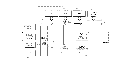
Fig. 6 is a block diagram of a vehicle navigation
system for use with the present invention; and
Figs. 7A and 7B are flowcharts illustrating
operation of two specific embodiments of the present
invention.
DESCRIPTION OF THE PREFERRED EMBODIMENT
The present invention relates generally to commonly
assigned United States Patents No. 5,345,382 to Kao for
CALIBRATION METHOD FOR A RELATIVE HEADING SENSOR, No.
5,359,529 to Snider for ROUTE GUIDANCE ON/OFF-ROUTE STATE
FILTER, No. 5,374,933 to Kao for POSITION CORRECTION METHOD
FOR VEHICLE NAVIGATION SYSTEM, and No. 5,515,283 to Desai et
al. for METHOD FOR IDENTIFYING HIGHWAY ACCESS RAMPS FOR ROUTE
CALCULATION IN A VEHICLE NAVIGATION SYSTEM..
Fig. 6 is a block diagram of a specific embodiment
of a vehicle navigation system 10 for use with the present
invention. Sensors 12 and 14 and GPS receiver 18 are coupled
to computing means 20 through sensor/GPS interface 22. In
typical embodiments, mileage sensor 12 comprises an odometer,
and angular velocity sensor 14 comprises a gyroscope, or a
differential odometer coupled to the wheels of the vehicle. A
CA 02224021 1997-12-OS
global positioning system (GPS) data receiver 18 is provided
for receiving signals from, for example, a satellite-based
navigation system. Data from sensor/GPS interface 22 is
transmitted to CPU 24, which performs calibration, signal
5 processing, dead-reckoning, vehicle positioning, and route
guidance functions. A database containing map information may
be stored in database medium 26, with software directing the
operation of computing means 20 stored in main memory 28 for
execution by CPU 24. Memory 28 may comprise read-only memory
(ROM), or reprogrammable non-volatile memory such as flash
memory or SRAM. System RAM 30 permits reading and writing of
the information necessary to execute such software programs.
Database medium 26 may comprise non-volatile memory, a hard
disk drive, CD-ROM, or an integrated circuit in which
digitized map information has been stored. Output controller
32, which may comprise a graphics controller, receives data
processed by CPU 24 and transmits the data to display console
40 which includes output communicator 34, usually comprising a
display screen with associated audio electronics and audio
speakers. The driver may input data, such as a desired
destination, through user interface 36, typically comprising a
keyboard.
The map database stored in database medium 26
preferably comprises positional data such as, for example,
latitude and longitude coordinates, to describe road
intersections or nodes, road segments, landmarks and points of
interest, and other geographical information. The data base
may further comprise data representing characteristics of
roads or places on the map, such as road and place names, road
features such as dividers, one-way restrictions, surface,
speed limit, shape, elevation, and other properties.
According to specific embodiments of the invention, the map
database includes cost values associated with individual nodes
and road segments. These cost values correspond to the
estimates of time intervals for traversing the respective node
or segment. Node cost values take into consideration such
information as, for example, whether the vehicle would
encounter oncoming traffic, thus delaying a left turn
CA 02224021 2000-04-07
6
maneuver. Segment costs reflect road segment characteristics
such as speed limit and segment length, both of which affect
the travel time along the segment. Also associated with each
road in the map database is a link class which relates to the
category or type of the road. For example, the highest level
category of the hierarchy is the link class FREEWAY. The
lowest level includes the link classes FRONTAGE and MISC which
include, for example, frontage roads and alleys.
The vehicle navigation system of the present
invention is operable to generate a route from a source
location to a destination according to a variety of different
methods. Some examples of such methods are described in the
U. S . patents mentioned abo~te .
20
Fig. 7A is a flowchart 700 illustrating operation of
a specific embodiment of the present invention. As discussed
above, the system searches its map database for road segments
to include in the generated route according to any of a
variety of search algorithms (step 702) until the destination
is reached (step 704). When a new maneuver has been included
in the route (step 706) a threshold distance is determined
(step 708). As long as no new maneuvers are encountered, the
algorithm continues to search for road segments. The
threshold distance is the distance within which a second
maneuver would be considered potentially difficult or
dangerous. The threshold distance may be-determined according
to various embodiments of the invention. For example, the
threshold distance may be a fixed distance, e.g., 200 feet.
Alternatively, the threshold distance may vary with the type
of road segment which connects the two maneuvers: That is,
the threshold distance for a freeway would be greater than
that for a major surface street in a residential area.
CA 02224021 1997-12-OS
7
Once a threshold distance is determined, a second
maneuver is identified which could potentially be included in
the generated route (step 710). If the second maneuver is
within the threshold distance (step 712), the cost associated
with that maneuver is increased to decrease the likelihood
that the maneuver will be included in the generated route
(step 714). The search algorithm then continues to generate
the route based at least in part on this increased cost. If
the second maneuver is not within the threshold distance, the
algorithm continues to search for additional road segments in
the usual-manner.
Fig. 7B is a flowchart 701 illustrating an alternate
embodiment of the present invention. Steps 702 through 708
are substantially the same as discussed above with reference
to Fig. 7A. However, once the threshold distance is
determined, the.algorithm determines whether there any
potential maneuvers within the threshold distance (step 711).
If there are none, the algorithm continues to search for
additional road segments. If, however, potential maneuvers
are identified within the threshold distance, the cost
associated with each of the maneuvers is increased to decrease
the likelihood that the maneuver will be included in the
generated route (step 713). The search algorithm then
continues to generate the route based at least in part on
these increased costs.
The manner in which the costs associated with
maneuvers are increased may vary according to different
embodiments of the invention. For example, a fixed increment
may be applied to the cost. Alternatively, the increment
applied to the cost may vary according to the distance between
the first and second maneuvers. Additionally, the magnitude
of the increment may be dependent upon the type of road
segment connecting the two maneuvers and/or the speed limit on
that segment. It will be understood that the scope of the
present invention includes but is not limited to these
embodiments.
While the invention has been particularly shown and
described with reference to specific embodiments thereof, it
CA 02224021 1997-12-OS
8
will be understood by those skilled in the art that the
foregoing and other changes in the form and details may be
made therein without departing from the spirit or scope of the
invention. For example, the embodiments of the present
invention have been described above with reference to
manipulation of the cost associated with a second maneuver to
effect the goal of avoiding inclusion of difficult or
dangerous successive maneuvers in a generated route. However,
it will be understood that the present invention would
encompass a system in which the search algorithm is prohibited
from including a second maneuver within a threshold distance
of a first maneuver in a generated route. This may be
accomplished by dramatically increasing the cost of the second
maneuver. It could also be achieved through some other
mechanism which causes the search algorithm to ignore the
maneuver and its associated road segments. Such a mechanism
might, for example, remove such maneuvers from the map
database for the current search. Alternatively, the system
might develop a list of such maneuvers which are prohibited
from inclusion in the route, checking each new segment
candidate against the list and eliminating any matches from
consideration. These are only some of the many possibilities
within the scope of the invention. In view of the foregoing
discussion, the scope of the invention should therefore be
determined by reference to the appended claims.