Note : Les descriptions sont présentées dans la langue officielle dans laquelle elles ont été soumises.
CA 02448545 2003-11-27
METHOD AND DEVICE FOR GENERATING TWO-DIMENSIONAL FLOOR PLANS
PRIORITY DATA
This application claims the benefit of US provisional application No.
60/430,584 filed on
December 3, 2002.
TECHNICAL FIELD
The subject invention relates generally to the property management, building
and
construction industry, and more particularly to a novel method and device for
mapping a
building or other structure in two dimensions in order to generate digital
floor plans.
BACKGROUND OF THE INVENTION
The original floor plans and architectural blueprints for a structure are
often lost or
unavailable to a building's owners. Even if the original documents are
available, these
documents may also contain significant deviations from the building "as
built", due to
renovations and other factors. Further, they may not be in a digital format,
or are in a format
no longer supported by existing software systems. In such cases, a labor and
time intensive
effort is needed to measure the data manually and generate new plans. The
conventional
method of using tape measurements is also inadequate because the level of
accuracy is
relatively poor.
An architect, renovator, property manager, appraiser or owner would prefer to
avoid a costly
and error-prone data entry process and generate, directly from the building, a
two-
dimensional floor plan of the structure as it currently exists.
To improve efficiency and accuracy, it is desirable to automatically record
the measurements
directly onto an electronic recording device and transfer the stored data to a
computer for
processing and generation of a finished plan in digital form. Several
approaches have been
proposed in the prior art, as described below.
U.S. Patent No. 4,205,385, issued to Erickson et al., describes a surveying
system that
provides automatic calculation and direct readout of various parameters and
vectors
encountered during a survey. It comprises a theodolite, a level sensor, and an
on board
microcomputer that can be used in conjunction with an electronic distance
measuring
instrument. The device translates raw data, comprising horizontal angle,
vertical angle, and
slope range, into the more useful component vectors, horizontal distance,
latitude, departure,
1
CA 02448545 2003-11-27
and elevation. Measurements must be taken from a stationary traverse location
that is fixed
relative to the area or object being measured. The requirement of a stationary
traverse
location makes the measuring process tedious, time consuming, and expensive.
Additionally,
the user cannot view his work as it progresses for verification and
correction, since this
device does not operate as a real-time input device for a computer and
associated applications
software.
U.S. Patent No. 5,091,869, issued to Ingram et al., proposes a complex method
for devising a
floor plan comprising the selection of traverse points, the setting up of a
surveying instrument
on the traverse point and measuring distances and angles to prominent points
on the floor. A
further traverse point is then selected and the process repeated until all the
data are collected.
The data is then transferred to a separate computer and converted into a floor
plan. The
gathering of the data, according to Ingram et al., is a demanding operation
that requires at
least two persons.
It would thus be advantageous to provide a method and device that overcomes
the drawbacks
of the prior art. For example, it would be beneficial to provide an integrated
device that
enables a single operator to devise digital floor plan in a relatively short
time.
U.S. Pat. No. 5,675,514, issued to Lefebvre, describes a spatial data recorder
that is easy to
use and can be manipulated by a single operator. The recorder has a base
module and a
remote module, which are linked through an extendable cable. The length and
the angular
orientation of the extendable cable are measured to determine the relative
spatial position of
the remote module with respect to the base module. With this spatial data
recorder, the base
module must be repositioned relatively often, which increases the time
required to devise the
plan of a floor. Furthermore, the use of an extendable cable between the
modules may, in
some instances, hinder the use of the system.
While the prior art methods can be used to produce a floor plan of a building,
they are all
variations of traditional surveying methods that successively measure point to
point, using
multiple steps and triangulation to create needlessly complicated two and
three dimensional
models from which a two dimensional floor plan is produced.
SUMMARY OF THE INVENTION
It is an object of the present invention to provide a novel device and method
of creating two-
dimensional floor plans which obviates or mitigates at least one disadvantage
of the prior art.
2
CA 02448545 2003-11-27
According to a first aspect of the present invention, there is provided a
method for generating
a digital, two-dimensional floor plan for the exterior of an existing
building. The method
comprises drawing a first linear representation of a first object of a
physical structure on the
display screen of a portable computer using at least one input device,
pointing at least one
device that measures both distance and relative angles from the near corner
position of said
first object to the far corner position of said first object, transmitting
said distance and angle
to said portable computer, so that the length of the first linear
representation can be adjusted
to match an appropriate display scale, drawing a linear representation of a
second object that
is adjacent the first object, pointing said measuring device at the far corner
position of said
second adjacent object, to measure a new distance and angle, transmitting said
second
distance and angle to said portable computer so that the length of the second
linear
representation can be adjusted to match an appropriate display scale, and
repeating the
previous steps until the relative lengths and angles of every object of the
structure is
calculated and displayed onto a digital floor plan.
According to another aspect of the present invention, there is provided an
apparatus for
devising, on-site, a two dimensional floor plan from a physical structure,
comprising a
portable computer capable of running CAD software, at least one input device
to manually
sketch initial dimensions of objects within a physical structure onto a
display screen of said
computer, at least one portable device for measuring distances and angles
between objects
within a structure, means to transmit linear and angular measurements to said
computer, and
customized CAD software running on said computer that is configured to
calculate an
appropriate display scale to show on said screen, and to adjust the initial
linear
representations so that they conform to the calculated display scale, and to
adjust the relative
angles between objects based on the measurements received from said portable
measuring
device.
BRIEF DESCRIPTION OF THE DRAWINGS
Embodiments of the present invention will now be described, by way of example
only, with
reference to the attached Figures, wherein:
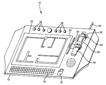
FIG. 1 is a perspective view of an integrated instrument that both records and
generates
digital floor plans;
FIG. 2 is a schematic block diagram of the connections between the various
components
of the integrated instrument of FIG. 1;
3
CA 02448545 2003-11-27
FIG. 3 depicts the procedure for generating floor plans for exterior walls;
FIG. 4 depicts a schematic top plan view of a generic building, used in
conjunction with
the exterior floor plan procedure of FIG. 3; and
FIG. 5 through FIG. 8 depict schematic top plan views illustrating a
simulation for
generating floor plans for interior walls.
DETAILED DESCRIPTION OF THE PREFERRED EMBODIMENTS
FIG. 1 illustrates an instrument, denoted generally at 10 and constructed
according to the
invention, used to measure wall lengths in a building or structure in the
example under
consideration. In the FIG. 1 embodiment, the instrument 10 is held without any
form of
mechanical support. In this embodiment, the instrument 10 is small and light
enough to be
held with one person's arm, and consists of a thin, rectangular housing 15
that encloses a
computer 20 and related operating system required to run a customized computer
aided
drafting (CAD) program. The upper surface of instrument 10 is substantially
composed of a
touch sensitive screen or pen tablet 25. Adjacent to the screen is an input
device, which may
include, but not restricted to, a stylus 30, mouse 32, and keyboard 34. A
series of pre-
programmed buttons 36 may also be included next to the screen, whose purpose
will be
explained shortly.
Also included with the instrument is a detachable, distance-measuring unit 50.
Laser-based
measurement units are common in the field, and include, for example, a
handheld Leica
DistoTM class 2 laser with accuracy of f 3 mm or better. Since a laser beam
consists of
electromagnetic radiation traveling at the speed of light, very accurate
measurements can be
performed with this type of unit.
It is also pointed out that the distance-measuring device 50 of the instrument
illustrated may
also be designed in such a manner as to require the placement of reflectors on
each measuring
point. This embodiment would not be preferred because the measurement setup
would be
more complicated. Alternatively, mechanical or sonar type devices can also be
used to
measure distance.
As more clearly seen in FIG. 2, the distance-measuring unit 50 is outfitted
with a data transfer
device 55, preferably wireless-based, that allows the transfer of recorded
data into the
integrated computer via a receiver 40. Also included with said distance-
measuring unit 50 is a
measuring unit 60 that measures the relative angle between two surfaces, or
other building
features, such as the angle between a wall and a column used in triangulation
or an angle
4
CA 02448545 2003-11-27
between a surface and a corner between another set of walls, again for
triangulation purposes.
The angle-measuring unit transmits said data via a data transfer device 65 to
a receiver 40.
Preferably, the angle-measuring unit is a gyroscope. Alternatively, a
theodolite can be used.
The data transfer devices 55, 65 between the computer 30 (via receiver 40) and
the distance
and angle-measuring units, respectively, preferably operate in a wireless
manner.
In a general mode of operation, the operator would first sketch out the floor
plan of the
structure of interest using one or more of the input devices 30, 32, and 34.
Then, the distance-
measuring unit and associated angle-measuring unit is removed and held by the
operator in
order to measure the dimensions of each room, as described below. The sequence
of steps
provided in the system and method of the invention are detailed in FIG. 3 and
schematically
illustrated in FIG. 4 through FIG. 8.
Ideally, the exterior floor plan is generated first. The instrument is set up
outside the building
to be measured, with small laser targets protruding slightly from each corner
of the building.
The targets do not need to be reflective in nature. Only one person is
required to both
measure dimensions and generate floor plans.
Alternatively, mechanical or sonar type devices can be used to measure
distance in order to
dispense with the need for reflectors or targets.
As a further alternative, if CAD drawings or other digital representations of
the exterior top
plan view exist, they can be imported into the customized CAD software and the
separate
procedure for generating the interior floor plan can be followed.
As illustrated in FIG. 3 and FIG. 4, the operator first draws one of the
outside perimeter walls
AB on the pen tablet screen 25 using at least one input device, such as a
stylus 30. The wall
type (e.g. straight, curved) is chosen from a choice of options in the
associated computer
software, accessible for example, by pressing one or more buttons 36, or from
a selection of
drop down menus incorporated in the CAD software. More simply, the wall type
may be set
to straight as the default by the CAD software. The operator then positions
the detachable
distance-measuring unit 50 at any first corner of the perimeter, shown as
corner A in
perimeter wall AB in FIG. 4. The laser beam is directed parallel to the wall
AB and directly
at the target protruding from corner B, so that the distance from corner A to
corner B is
measured. The associated angle-measuring unit 60 is set to a zero reference
angle. The data is
transmitted to the computer and the CAD program adjusts the scale of the
drawing displayed
on the screen 25.
One of the adjoining walls, BC in the example, is then drawn on the screen 25.
The operator
then positions the measuring units 50, 60 at the junction of the first and
second walls, corner
5
CA 02448545 2003-11-27
B, and directs the laser to a target adjacent corner C to obtain an accurate
reading for the
length of the second wall BC, and the direction of wall BC relative to the
first reference wall
AB. In practice, this direction is usually close to 90 degrees. The relative
distance and angle
are transmitted to the computer and adjustments made to the sketched wall in
proportion to
the display scale.
Next, a third wall CD, adjoining the second wall BC, is drawn and the operator
then directs
the measuring units 50, 60 from the corner C to the far corner D, to obtain an
accurate
reading for the relative length and direction of the wall CD. The process is
repeated around
the entire perimeter of the house, setting the length with the distance-
measuring unit 50 and
the direction with the angle-measuring unit 60.
Refernng now to FIG. 5 through FIG. 8, the use of the instrument for interior
dimensions is
illustrated to devise an interior floor plan having a plurality of walls. For
each Figure, the
plan is illustrated on the display screen 25, first as a sketch, then as a
finished dimension once
the distance and angle-measuring units 50, 60 are used to set the actual
distance and direction
between walls.
The operator first chooses one of the interior rooms in the comer as a
starting point, labeled
R1 in FIG. 5, and manually draws the two inside walls 101, 102 on the display
device 25
using an input device, for example, a stylus 30. The wall type, in this
example straight, is
chosen by one of the pre-programmed buttons 36, or from a selection of drop
down menus
incorporated in the CAD software. More simply, the wall type may be set to
straight as the
default by the CAD software.
The other two walls, 103 and 104, form part of the exterior walls EF and FA,
respectively,
and are already defined in the CAD system from the previously determined
exterior floor
plan.
The operator then directs the detachable measuring units 50, 60 toward the
actual interior
corners to measure the relative lengths and directions. Ideally, the operator
can start at one of
the corners, for instance at the junction of walls 101 and 102, to directly
measure the lengths
of walls 101, 102 and indirectly measuring the lengths of walls 103 and 104 by
triangulation.
The lengths of these walls can also be verified by direct measurement. The
relative lengths
and angles are transmitted to the computer and the CAD software adjusts the
sketched lines
accordingly.
Next, in FIG. 6, the operator draws openings, fixtures, stairwells and other
features by
selecting from drop down menus incorporated in the CAD software, or by
pressing one of the
6
CA 02448545 2003-11-27
pre-programmed buttons 36. The distance-measuring tool 50 can correct the
positioning
directly on the CAD drawing.
Next, in FIG. 7, the adjacent room R2 is sketched in by one or more input
devices, including
openings and other miscellaneous features. The measuring units 50, 60 are then
used to
correct for relative wall lengths and orientation, as in the same manner as
previously
described. The distances can be checked from the previous room, which
eliminates the need
to actually determine the wall thickness.
The previous step is repeated for each successive room, labeled as R3, R4, and
RS in FIG. 8.
The distance-measuring unit can be used to measure overall dimensions as they
become
available, or to check against the anchor walls obtained from the exterior
floor plan. When a
particular room is finished, the CAD software prompts the operator to supply a
name, and the
room dimensions are then permanently stored onto the floor plan along with
labels in digital
format.
In all cases, the CAD system accepts relatively simple linear and angular
input from the
measuring units 50 and 60, respectively, and adjusts the distances and angles
between linear
representations displayed on a screen. Prior art systems measure absolute
spatial data, usually
in three dimensions, and transmit distances from the measuring unit to a base
station. The
applicant's disclosed system only transmits relative dimensions and angles and
transforms
initial linear representations into accurate scaled dimensions, never
requiring a three-
dimensional model. However additional "Z"-axis information such as ceiling
heights,
window heights, etc. are easily measured and recorded if the user so desires.
In a further embodiment, the instrument 10 also includes a GPS receiver, which
allows the
placement of a structure onto a street map, and a digital compass, which
provides the
orientation of a structure relative to magnetic north by placing and orienting
a North Arrow
on the plan relative to a predetermined direction such as the street-facing
perimeter wall.
In another embodiment, a heads up screen and a virtual reality type control
glove replaces the
pen tablet 25 and input devices 30, 32, 34.
In yet another embodiment, measurement designation and other functions are
controlled by
voice recognition software.
In still another embodiment, the CAD program resides on a remote server, and
the
information is transmitted wirelessly to the central server and processed at
the server in real
time. This arrangement reduces the need for processing power on site and thus
reduces the
size and weight and the cost of the tablet computer, writing screen or heads
up screen.
7
CA 02448545 2003-11-27
Although this invention has been described in conjunction with specific
embodiments, many
modifications and variations which do not depart from the scope of the
invention, as defined
by the attached claims, will be apparent to those skilled in the art.