Note : Les descriptions sont présentées dans la langue officielle dans laquelle elles ont été soumises.
CA 02556985 2006-08-21
WO 2005/083471 PCT/EP2004/050981
Method and System for automated location dependent probabilistic
tropical cyclone forecast
This invention relates to a method and system for automated location
dependent probabilistic tropical cyclone forecast, whereas data records of
s tropical cyclone events are generated and location dependent probability
values
for specific weather conditions associated with the tropical cyclone are
determined. In particular, the invention relates all kind of tropical cyclones
as
e.g. hurricanes, typhoons and tropical storms.
Each year, tropical cyclones (also referred to as hurricanes, typhoons
to and tropical storms etc.) cause severe damage in various parts of the
world. The
occurrence of such weather events is difficult, if not impossible, to predict
over
the long term. Even the path, or track, of an existing storm can be difficult
to
predict over a period of hours or days. In particular, the given examples in
this
document address hurricanes, whereas typhoons and tropical storms etc. can
is be treated in the same manner. Hurricanes is the most severe category of
the
meteorological phenomenon known as the "tropical cyclone." Hurricanes, as all
tropical cyclones, include a pre-existing weather disturbance, warm tropical
oceans, moisture, and relatively light winds aloft. If the right conditions
persist
long enough, they can combine to produce the violent winds, incredible waves,
2o torrential rains, and floods we associate with this phenomenon. So, the
formation of a tropical cyclone and its growth into e.g. a hurricane requires:
1 ) a
pre-existing weather disturbance; 2) ocean temperatures at least 26°C
to a
depth of about 45m; and 3) winds that are relatively light throughout the
depth of
the atmosphere (low wind shear). Typically, tropical storms and hurricanes
2s weaken when their sources of heat and moisture are cut off (such as happens
when they move over land) or when they encounter strong wind shear. However,
a weakening hurricane can reintensify if it moves into a more favorable
region.
The remnants of a landfalling hurricane can still cause considerable damage.
Each year, an average of ten tropical storms develop over the Atlantic Ocean,
3o Caribbean Sea, and Gulf of Mexico. Many of these remain over the ocean. Six
of
these storms become hurricanes each year. In an average 3-year period,
roughly five hurricanes strike e.g. the United States coastline, killing
approximately 50 to 100 people anywhere from Texas to Maine. Of these, two
are typically major hurricanes (winds greater than 110 mph). As mentioned a
3s hurricane is a type of tropical cyclone, which is a generic term for a law
pressure
system that generally forms in the tropics. The cyclone is accompanied by
CA 02556985 2006-08-21
WO 2005/083471 PCT/EP2004/050981
thunderstorms and, in the Northern Hemisphere, a counterclockwise circulation
of winds near the earth's surface. Tropical cyclones can be classified as
follows:
(i) Tropical Depression: An organized system of clouds and thunderstorms with
a defined surface circulation and maximum sustained winds (Sustained winds
s are defined as a 1-minute average wind measured at about 10 meters above the
surface) of 33 kt or less (1 knot = 1 nautical mile per hour or 1.15 statute
miles
per hour); (ii) Tropical Storm: An organized system of strong thunderstorms
with
a defined surface circulation and maximum sustained winds of 34-63 kt; (iii)
Hurricane: An intense tropical weather system of strong thunderstorms with a
to well-defined surface circulation and maximum sustained winds of 64 kt or
higher.
Hurricanes are categorized according to the strength of their winds using the
Saffir-Simpson Hurricane Scale. A Category 1 storm has the lowest wind
speeds, while a Category 5 hurricane has the strongest. These are relative
terms, because lower category storms can sometimes inflict greater damage
is than higher category storms, depending on where they strike and the
particular
hazards they bring. In fact, tropical storms can also produce significant
damage
and loss of life, mainly due to flooding. Normally, when the winds from these
storms reach 34 kt, the cyclone is given a name. It should be mentioned, that
the
category of the storm does not necessarily relate directly to the damage it
will
2o inflict. Lower category storms (and even tropical storms) can cause
substantial
damage depending on what other weather features they interact with, where
they strike, and how slow they move.
As mentioned the Saffir-Simpson Hurricane Scale (SS-Scale) defines
hurricane strength by categories. A Category 1 storm is the weakest hurricane
2s (winds G4-82 kt); a Category 5 hurricane is the strongest (winds greater
than
135 kt). Relating to the caused damage, it can be said, that typically
Category 1
storms with winds between 64-82 kt can cause normally no real damage to
building structures. Damages are primarily to unanchored mobile homes,
shrubbery, and trees. There can be also, some coastal flooding and minor pier
3o damage. Category 2 storms with winds between 83-95 kt can cause normally
some roofing material, door, and window damage. There can also be
considerable damage to vegetation, mobile homes, etc. or flooding damages
piers and small craft in unprotected moorings may break their moorings.
Category 3 storms with winds between 96-113 kt can cause normally some
ss structural damage to small residences and utility buildings, with a minor
amount
of curtainwall failures. Mobile homes are destroyed. Aslo, flooding near the
coast destroys smaller structures with larger structures damaged by floating
CA 02556985 2006-08-21
WO 2005/083471 PCT/EP2004/050981
debris. Terrain may be flooded well inland. Category 4 storms with winds
between 114-135 kt can cause normally more extensive curtainwall failures with
some complete roof structure failure on small residences. There can be also
major erosion of beach areas. Terrain may be flooded well inland. Finally
s Category 5 storms with winds between 135+ kt can cause normally complete
roof failure on many residences and industrial buildings. There can be some
complete building failures with small utility buildings blown over or away.
Flooding causes major damage to lower floors of all structures near the
shoreline. Massive evacuation of residential areas may be required.
to Nevertheless, insurance companies and other entities need to
develop ways of assessing the risks associated with such weather events, and
factoring that knowledge into the pricing of insurance products and the
magnitudes and frequencies of damages to expect over time. Information is
available for use in this regard in the form of historical data on storms
which
is have occurred through the years. Approximately 80 such storms occur
worldwide each year. Data are collected on many of these storms, including
positional data for the storm path or "track," wind speeds, barometric
pressures,
and other factors. Such storms are best documented in the North Atlantic
(i.e.,
the portion of the Atlantic Ocean north of the equator), where reliable data
for
2o more than 100 years of activity are available. Approximately 10 storms
occur in
the North Atlantic region on an annual basis. Historical data are also
available
for cyclones occurring in the Northwest Pacific, where approximately 26 storms
occur each year. Suitable data for these Pacific storms are available only for
the
last approximately 50 years. Less data are available for storms in other
regions.
2s Using all available historical data, information relating to a few
hundred storms is available for review by researchers and scientists. Such
information is useful in assessing risks associated with storm damages in the
subject areas. However, given the unpredictable nature of storm behaviour, and
the number of factors influencing such behaviours, the available data set of
so historical storms is relatively small from a probabilistic viewpoint. Given
that this
data set will grow by only a relatively few storms per year, a problem exists
with
regard to performing statistical analysis relating to the possibility of a
storm
occurring at a particular location.
One manner in which this problem can be addressed is by generation
3s of simulated or "alternative" storms, and using data from such "storms" to
CA 02556985 2006-08-21
WO 2005/083471 PCT/EP2004/050981
4
expand the data set available from historical records. This approach can
result
in the availability of thousands, or even tens or hundreds of thousands, of
additional storms from which to create data sets large enough to perform
reliable
statistical analyses. The subject invention is directed to various embodiments
s involving uses of method, a system and a computer program product for
generating such expanded probabilistic data sets.
Therefore it should be pointed out that, besides the method according
to the invention, the present invention also relates to a system and a
computer
program product far carrying out this method.
to In particular the objects are achieved through the invention in that for
automated location dependent tropical cyclone forecast data records of weather
events are generated and location dependent probability values for specific
weather conditions associated with the tropical cyclone are determined;
whereas
data records representative of an historical track of a weather event are
is assigned to a year of occurrence of said weather event and are saved on a
memory module of a calculating unit, said data records including a plurality
of
points representative of geographical positions and/or intensity of the event
along the historical track; whereas a plurality of new data records
representative
of alternative tracks are generated for each historical track by means of a
2o MonteCarlo-module, wherein points of said new data records are generated
from said points along the historical track by a dependent sampling process;
whereas a grid over a geographical area of interest is established by means of
the calculation unit, said area including at least a portion of the plurality
of
historical tracks, and a intensity climatology for selected cells in the grid
is
2s generated, based upon the intensity data associated with at least some of
the
plurality of points along the historical tracks located within said selected
grid
cells; whereas for each of said alternative tracks one or more new intensity
data
are generated by means of a second MonteCarlo-module, wherein the one or
more new intensity data of the new data records of said alternative tracks are
so generated from the intensity data associated with at least some of the
plurality of
points along the historical tracks by a MonteCarlo sampling process; whereas a
distribution for a definable time period of the data records of the historical
tracks
is generates by means of a scaling table classifying the weather events by
intensity and/or year of occurrence, and said distribution of said historical
tracks
3s are reproduced by a filtering module within the new or cumulated data
records
according to their assigned year; and whereas a wind field of each data record
CA 02556985 2006-08-21
WO 2005/083471 PCT/EP2004/050981
is generated based on a definable wind field profile, and a probability is
assigned by a interpolation-module to each point in said grid, giving the
probability of the occurrence of a specific wind strength at a given
geographical
location and time. As basis for the scaling table the SafFir-Simpson Hurricane
s Scale can for example be used. The first and second MonteCarlo-module as
well as the interpolation-module can be realized b~ hardware and/or software.
One embodiment of the invention comprises a method for generating a
probabilistic data set relating to a weather event, such as a tropical
cyclone, or
hurricane, typhoon, or tropical storm. This embodiment of the method includes
the
1o steps of inputting data representative of an historical track of a weather
event and
generating data representative of a plurality of alternative tracks based on
the historical
track. The data points representative of the alternative tracks are generated
from
respective points along the historical track by a depend ent sampling process.
In certain
embodiments, the dependent sampling process is a directed random walk process.
is In one embodiment, the step of generating data representative of
alternative tracks based on the historical track comp prises the steps of
generating
a series of random tuples (x~,y~) for a historical poinlt (x,y) of the
historical track,
calculating a sum of random deviations (x',y') of the random tuples along the
historical track, and adding the sum of random de~riations (x',y') to the
historical
2o point (x,y) of the historical track to produce alternative points along the
alternative tracks.
The data representative of the historical tracks) include a plurality of
points representative of geographical positions along the historical track(s).
The
generated data representative of a plurality of alternative tracks includes a
2s plurality of alternative points representative of geographical positions
along the
alternative tracks. In one embodiment, at least sorr~e of the plurality of
alternative tracks associated with a particular historical track have starting
points
that difFer from a starting point of the historical tract-c upon which the
alternative
tracks are based. The data representative of the historical track may comprise
30 longitude and latitude data to define a location of each of a plurality of
points.
In certain embodiments of the methad, the step of inputting data
representative of an historical track includes the step of inputting at least
one of:
longitude and latitude of a plurality of points representative of the
historical
track; an azimuth angle for at least some of the points along the historical
track;
3s celerity for at least some of the points along the historical track; a rate
of change
CA 02556985 2006-08-21
WO 2005/083471 PCT/EP2004/050981
6
of azimuth angle for at least some of the points along the historical track;
and a
rate of change of celerity for at least some of the points along the
historical
track. Alternatively, the latter values (azimuth, celerity, and rates of
change of
azimuth and celerity) may be calculated from longitude and latitude data
s recorded at periodic time intervals.
Some embodiments of the subject method further comprise the step
of selecting a subset of the data representative of the alternative tracks for
use
in the probabilistic data set. In these or other embodiments, the step of
generating data representative of alternative tracks includes the step of
limiting
to a variance of the alternative points from a respective historical point in
accordance with one or more physical laws.
In certain embodiments of the subject method, the step of inputting
data representative of a track of an historical weather event includes
inputting
data representative of an intensity of the event. The data representative of
is intensity may comprise atmospheric pressure data associated with at least
some
of the plurality of points along the historical track. The atmospheric
pressure
data defines an historical pressure profile of the historical track. The
atmospheric pressure data may include an absolute pressure and a derivative of
(or change in) absolute pressure with respect to time. In certain embodiments,
2o the atmospheric pressure data includes one or more pressure distributions.
In
some embodiments of the subject method, the step of inputting data includes
inputting data representative of a plurality of historical tracks, and the
step of
establishing a grid over a geographical area of interest including at least a
portion of the plurality of tracks. These embodiments may further comprise the
2s step of establishing a pressure climatology for selected cells in the grid,
based
upon the atmospheric pressure data associated with at least some of the
plurality of points along the historical tracks located within the selected
grid
cells. The pressure climatology for the selected cells may be a pressure
distribution function. The pressure climatology for a selected cell in the
grid may
3o be established from the atmospheric data associated with the selected cell
and/or the atmospheric pressure data associated with one or more cells
adjacent the selected cell (i.e., one or more neighboring cell). In certain
embodiments, the pressure climatology for a selected cell is established from
a
weighted averaging of pressure data associated with the selected cell and
3s pressure data associated with one or more neighboring cell.
In certain embodiments, each cell in the grid is assigned a landlsea
value. In these embodiments, pressure data associated with an adjacent cell is
CA 02556985 2006-08-21
WO 2005/083471 PCT/EP2004/050981
7
used to establish the pressure climatology of the selected cell only if the
adjacent and the selected cell have the same land/sea value.
Certain embodiments of the subject method comprise the additional
step of generating one or more alternative pressure profi les for one or more
of
s the historical tracks using the pressure climatology for the selected cells
in the
grid. In addition, one or more pressure profiles may be generated for one or
more of the alternative tracks. One or more alternative pressure profiles may
also be generated for one or more of the alternative tracks using the pressure
climatology for the selected cells of the grid. In some embodiments, at least
one
of the alternative pressure profiles for the historical tracks, the pressure
profiles
for the alternative tracks, and the alternative pressure profiles for the
alternative
tracks are modified based, at least in part, on the historical pressure
profile
along the historical track of the associated weather event.
In certain embodiments of the invention, the step of inputting data
is includes inputting data representative of a plurality of historical tracks
and
inputting data representative of atmospheric pressure associated with at least
some of the plurality of points along the historical tracks. The atmospheric
data
defines historical pressure profiles of the historical tracks. In these
embodiments, the step of generating data includes generating a plurality of
alternative tracks for more than one of the historical tracks. Further, these
embodiments include at least one of the following steps: a) generating ane or
more alternative pressure profiles for one or more of the historical tracks;
b)
generating one or more pressure profiles for one or more of the alternative
tracks; and c) generating one or more alternative pressure profiles for one or
2s more of the alternative tracks. These or other embodiments of the subject
method may further comprise the step of extracting a subset of data from the
data representative of the historical tracks, the alternative tracks, and the
pressure profiles, based on climatological conditions for a selected time
period.
Additional features and advantages will become apparent to those
so skilled in the art upon consideration of the following detailed description
of
illustrative embodiments exemplifying the best mode of carrying out the method
as presently perceived.
The present disclosure will be described hereafter with reference to
the attached drawings which are given as non-limiting examples only, in which:
ss Figure 1 is a flow chart which illustrates the overall operation of one
embodiment of the method of the present invention.
CA 02556985 2006-08-21
WO 2005/083471 PCT/EP2004/050981
Figure 2 is a flow chart which further illustrates the step of inputting
data for historical storms in the embodiment of Figure 1.
Figure 3 is a flow chart which further illustrates the step of
establishing a climatology in the embodiment of Figure 1.
Figure 4 is a flow chart which further illustrates the step of producing
alternative storm tracks in the embodiment of Figure 1.
Figure 5 is a flow chart which further illustrates the step of producing
alternative pressure evolutions in the embodiment of Figure 1.
Figure fi is a flow chart which further illustrates the steps of selecting
to a subset of alternative storms and calculating the wind field in the
embodiment
of Figure 1.
Figure 7 illustrates a method of generating points of a probablistic
data set which are representative of a portion of an alternative storm track.
Figure 8a illustrates a plurality of alternative storm tracks generated
1s by the method of Figure 7 using a normally-distributed random walk.
Figure 8b illustrates a plurality of alternative storm tracks generated
by the method of Figure 7 using an evenly-distributed random walk.
Figure 8c illustrates a plurality of alternative storm tracks generated
by the method of Figure 7 using a directed random walk.
2o Figure 9a illustrates a plurality of alternative storm tracks, each
originating at the starting point of a respective historical track.
Figure 9b illustrates a plurality of alternative storm tracks, each
originating at an alternative starting point relative to a respective
historical track.
Figure 10 illustrates a plurality of historical and alternative storm
2s tracks superimposed over a portion of a map.
Figure 11 (a,...,i) illustrates a plurality of alternative pressure
evolutions for each of a plurality of storms.
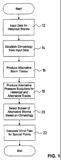
Figure 1 is a flow chart which illustrates the overall operation of one
embodiment of the subject method. The first step in this embodiment is
inputting
so data for a plurality of historical storms. This step is represented by
block 12 of
Figure 1. Such data includes geographical information defning the tracks of
the
CA 02556985 2006-08-21
WO 2005/083471 PCT/EP2004/050981
respective historical storms and intensity data to indicate the strength of
the
storm. One source of such data is the National Hurricane Center ("NHC") which
is part of the National Oceanic and Atmospheric Administration ("NOAA").
Geographic and intensity data for hurricanes and tropical cyclones and storms
s may be viewed at, and is available from, the NHC website at
www.nhc.noaa.gov.
Following the inputting of this data, a climatology is established in the area
of
interest. This operation is represented by block 14 in Figure 1. After
establishment of the climatology, alternative storm tracks are produced for
each
of the historical tracks in the inputted data. This step is represented by
block 16.
to Following production of the alternative storm tracks, a plurality of
alternative pressure evolutions are produced for the historical and
alternative
tracks. This step is represented in Figure 1 by block 18. Production of the
alternative starm tracks, and the alternative pressure evolutions for the
historical
and alternative tracks, creates a relatively large universe of storms (both
is historical and alternative). A subset of the alternative storms is selected
based
on climatological data. This step is represented by block 20. Finally, wind
fields
are calculated for specific points of interest. This step is represented in
the flow
chart of Figure 1 by block 22. Each of steps 12-22 are discussed in additional
detail below in connection with the flow charts of Figures 2-6.
2o Figure 2 is a flow chart which further illustrates the step of inputting
data for historical starms in the embodiment of Figure 1. The first operation
in
this step is represented by block 24 labeled "Read Raw Data." As previously
indicated, one source of data on historical storms is the National Hurricane
Center. These data include geographical (i.e., latitude and longitude) data
which
2s define individual nodes of the historical track. The locations of storms
are
generally reported at six hour time intervals. In many instances, intensity
data is
also provided in the form of a pressure measurement taken in the vicinity of
the
center of the node. In the event a central pressure measurement is not
provided,
a pressure may be calculated from the maximum sustained wind also available
30 on the site. These operations are represented by decision block 26 and
processing block 28.
After reading the raw data and, if necessary, calculating pressures,
additional calculations are performed to determine celerity, azimuth angles
and
SafFir-Simpson classes. These calculations are represented in the flow chart
of
ss Figure 2 by block 30. At this point, the data are checked and verified
(block 32).
After those operations, the original data may be interpolated to enhance
resolution. That is, additional geographical points or nodes may be defined
between the "six hour nodes" available in the raw data. The six hour nodes are
CA 02556985 2006-08-21
WO 2005/083471 PCT/EP2004/050981
interpolated to allow for a better geographical resolution. In one embodiment,
the data are interpolated to 0.2 degree steps. Such interpolation allows for
the
generation of smoother, alternative storm tracks, and enhances the overall
operation of the subject method. This operation is represented by block 34 of
s Figure 2.
The last operation in the step of inputting historical data relates to the
addition of "on-land" flags. When a storm moves from a position over water to
a
position over land (or vice versa), substantial pressure changes are observed.
Accordingly, landfall and land leave points are determined and entered into
the
to data for use in subsequent steps of the process. This operation is
represented in
the embodiment of Figure 2 by block 36.
Figure 3 is a flow chart which further illustrates the step of
establishing a climatology in the embodiment of Figure 1. Even though records
of more than 100 years of reliable pressure data exist, this historical data
is
is preferably preprocessed in order to obtain a more consistent database by
the
methods described herein. The first operation in the step of establishing a
pressure climatology is establishment of a 1 ° by 1 ° grid over
the geographical
area of interest. This operation is represented by step 38 in the embodiment
of
Figure 3. The original data includes both the absolute pressure at specified
locations, and the change in pressure (i.e., the pressure derivative). These
data
are matched with the individual grid locations (block 40). Some locations in
the
grid will have many observed pressure and pressure derivative values. Other
locations have fewer observed values, and yet others may have none.
Following this operation, minimum pressures based on the sea
2s surface temperature (SST) climatology are added. That is, for each location
in
the grid, the lowest pressure associated with the highest SST ever observed in
that particular location is entered. This value acts as a "floor" for
alternative
pressure values associated with each location in the grid that may be selected
(as discussed in additional detail below) in connection with alternative
pressure
3o evolutions for the historical and/or alternative storm tracks. This
operation is
represented by block 42 in the embodiment of Figure 3.
After addition of minimum pressures, the pressure climatology is
smoothed. The goals of the smoothing process include one or more of the
following: to obtain full coverage of the area of interest; to smooth
variations in
3s the distributions of pressures and pressure derivatives from one grid to
its
neighboring grids; to smooth variations in distributions of minimums, maximums
and means of the absolute pressures and pressure derivatives; and to obtain
the
CA 02556985 2006-08-21
WO 2005/083471 PCT/EP2004/050981
11
same number of "observations" at each grid location. This smoothing process
leads to a more consistent set of pressure related values for the area of
interest
to be used in a sampling process to be described further below. In the
particular
embodiment being described, the quantities to be smoothed are not sealer
s quantities (such as, a mean pressure quantity at each location), but rather
are
pressure-related distributions for each location. Accordingly, the smoothing
process is relatively more complex.
In order to achieve the goals stated above, ane embodiment of the
subject method follows the approach set forth below. Other approaches may be
to used, and some may very well be comparable to, or even preferred over, this
approach. The approach is as follows:
The number of valid observations at each location is determined. In
this embodiment, up to 260 observations for each location may be entered.
Some locations may have this many observations (or more) while other locations
is may have fewer or none. All non-valid data are replaced. The distinction
between valid observations and non-valid observations is based upon the fact
that pressure values below 800 hPa are impossible, and thus not valid. After
all
valid observations are entered for each location, the subject method loops
thraugh the data location, applying the following procedure at each location
20 (referred to as the "center location"):
1 ) Obtain all valid observations for the center location and all
neighboring locations (i.e., all grid cells surrounding the "center" cell)
having the
same land/sea value. That is, if the center location is a sea location, only
neighboring locations that are also sea locations are considered. If the
center
2s location is a land location, only neighboring locations that are also land
locations are considered. Thus, land and sea observations are not mixed in the
smoothing process.
2) Construct the pressure distribution file for all points. The center
location observations are more heavily weighted, for example, by counting them
so twice. Depending on the number of neighboring locations having the same
land/sea values and the number of valid observations at each location, an
arbitrary number of observations for this particular pressure distribution
file is
obtained.
3) Use a cubic spline to interpolate the pressure distribution function
3s to a standard number of observations (for example, 100 observations for
each
location).
CA 02556985 2006-08-21
WO 2005/083471 PCT/EP2004/050981
12
The above approach will produce a data set having a standard
number (for example, 100) of pressure and pressure derivative observations at
each grid cell which is not separated by more than 1 degree from an original
cell. By iteration, one can in theory fill all gaps existing in the area of
interest.
The above-described approach accomplishes the goals set forth
previously. Locations in which historical observations are not available
within
the area of interest are "filled in," and variations across the area of
interest are
smoothed. However, sharp pressure gradients which occur at land/sea transition
locations are maintained.
to The pressure climatology smoothing operation is represented in
Figure 3 by block 44. It should be noted that, in the described embodiment,
both
a land climatology and a sea climatology are established and smoothed in the
manner described above.
Figure 4 is a flow chart which further illustrates the step of producing
is alternative storm tracks in the embodiment of Figure 1. The first step in
this
operation is selection of one of the plurality of historical tracks (i.e.,
longitude
and latitude data) inputted in the first step of the overall process
illustrated in
Figure 1. The selection operation is represented in the flow chart of Figure 4
by
block 46. An alternative track is then generated for the selected historical
track.
2o The specific manner in which each alternative track is generated is
described in
additional detail below. This operation is represented in the flow chart of
Figure
4 by block 48. A plurality (N) of alternative tracks are produced. In the
embodiment of Figure 4 this is illustrated by the presence of decision block
50
and the resulting loop. Similarly, a plurality of tracks are generated for
each
2s historical track. This aspect of the operation is illustrated by the
presence of
decision block 52 and the resulting loop.
Following generation of the alternative tracks, the embodiment of the
method illustrated in Figure 1 produces an alternative pressure evolution
("APE") for each of the historical tracks and the alternative tracks. Figure 5
is a
3o flow chart which further illustrates the step of producing APEs in the
embodiment
of Figure 1. The first operation in this step is selection of an historical
track. This
operation is represented in Figure 5 by block 54. The next operation in this
step
is generation of an APE for a selected historical track. This operation is
represented in Figure 5 by block 56. A plurality (M) of APEs are generated.
This
3s feature is represented schematically by decision block 58, and the
resulting
loop.
CA 02556985 2006-08-21
WO 2005/083471 PCT/EP2004/050981
13
In addition to generating an APE for each historical track, it is
desirable to generate an APE for each alternative track associated with each
historical track. Accordingly, after generation of an APE for the first
historical
track, the method of this embodiment associates each alternative track
s generated from the selected historical track with the original pressure
evolution
of the historical track. This operation is represented in Figure 5 by block
60. An
APE is then generated for the alternative track (block 62). The methodology
for
generating the APE is the same as was used in connection with the operation
referred to in connection with block 56. A specific sampling process
applicable
to to this operation is discussed in additional detail below. A plurality (M)
of APEs
are generated for each alternative track. This feature is illustrated in
Figure 5 by
decision block 64, and the resulting loop. APEs are then similarly generated
for
each of the plurality (N) of alternative tracks associated with each
historical
track. This feature is illustrated by decision block 66 in Figure 5, and the
is resulting loop. Finally, the operation continues in this manner until APEs
have
been generated for all historical tracks and all associated alternative
tracks. This
feature is illustrated in the embodiment of Figure 5 by decision block 68, and
the
resulting loop.
Figure 5 is a flow chart which further illustrates the steps of selecting
2o a subset of alternative storms based on climatology in the embodiment of
Figure
1. The first operation in this step is selection of alternative tracks to
create a
plurality of "clone" years. Specifically, each historical year includes a
plurality of
historical storms. In accordance with the above discussion, a plurality (N) of
alternative tracks are created for each historical track in a given year.
However,
2s since the alternative tracks are produced by a random process (albeit one
that
uses a dependent sampling technique), some of the alternative tracks for a
given year are more likely to occur than others. The selection process is
based
upon knowledge of the climatology for the actual year in which the associated
historical storm tracks occurred. In other words, alternative tracks which
might
3o be judged as relatively unlikely to occur in actuality are deselected,
based on
established climatological knowledge. Thus, from the universe of alternative
tracks available to create a "clone" year, a selection is made to include
certain of
the alternative tracks and exclude others. This operation is illustrated by
block
70 in Figure 6.
3s An "adjustment" made to the data for the selected storms relates to
the previously discussed "on-land" flags. Since pressures increase rapidly
when
a storm moves from over water to over land, pressure data associated with the
CA 02556985 2006-08-21
WO 2005/083471 PCT/EP2004/050981
14
alternative tracks are adjusted to reflect this phenomena. This operation is
represented by block 72 in the flow chart of Figure 6.
The final step in the overall methodology illustrated by the flow chart
of Figure 1 relates to calculation of the wind field for particular points
along each
s storm path. Such calculations include application of Holland's Formula,
accounting for directional roughness values, and accounting for extra-tropical
transitions. These operations are represented by blocks 74, 76, 78, and 80 in
the flow chart of Figure 6.
As previously noted, the alternative storm tracks are generated by a
to dependent sampling technique. Figure 7 illustrates a method of generating
points of a probabilistic data set which are representative of an alterinative
storm
track. With reference to Figure 7, line segment 100 represents a portion of an
historical storm track. For purposes of discussion, an x-y coordinate system
has
been superimposed such that Ii ne 100 may be represented by three points, as
is follows:
x=0 1 2
y=0 1 1
Corresponding points of an alternative track, represented by line 102,
are produced by generating a series of random tuples (x~,y~) for each point of
the
2o historical track, then calculating the cumulative sum (x',y') of these
random
numbers along the track (i.e., summing up random deviations along the track),
and then adding these accumulated random deviations (x', y') to the historical
track (x,y). The resulting points define the alternative track. In the example
of
Figure 7, the random tuples are:
25 xr =1 0 -1
yr = 0 0 1
The cumulative sums along the alternative track are:
x'=1 1+0=1 1+(-1)=0
y'=0 0+0=0 0+1=1
3o Finally, the points on the generated track (line 102) are obtained as
follows:
x+x'=0+1=1 1+1=2 2+0=2
y+y'=0+0=0 1 +0=1 1 +1 =2
CA 02556985 2006-08-21
WO 2005/083471 PCT/EP2004/050981
There are different ways to generate the random numbers, either by
independently sampling from a normal or uniform distribution, or by a
dependent
sampling technique (such as, a directed random walk). Using the latter, a
subsequent point can only deviate to a certain degree from a previous point.
As
s will be illustrated in additional detail below, a dependent sampling
technique
(particularly, a directed random walk) generates more realistic alternative
storm
tracks.
Figs. 8a - 8c illustrate alternative storm tracks generated by the
above-described technique, using both independent and dependent sampling.
to Figure 8a illustrates the results achieved when the random numbers are
generated by independent sampling from a normal distribution. In Figure 8a,
heavy line 104 represents the historical track. The remaining lines represent
alternative tracks. The alternative tracks illustrate erratic storm movements
which are not likely to occur in nature.
1s Figure 8b shows historical track 104 and a plurality of alternative
tracks generated by an independent sampling technique wherein the random
numbers are generated from a uniform distribution. The alternative tracks in
this
example are much smoother than those illustrated in Figure 8a. However, the
alternative tracks in Figure 8b continue to exhibit unrealistic "movements" at
2o numerous points along the track.
Figure 8c shows historical track 104 and a plurality of alternative
tracks generated by a dependent sampling technique. In Figure 8c, each point
along an alternative track can only deviate to a certain degree from the
previous
point. As the results illustrate, this "directed random walk" generates
alternative
2s tracks which are more realistic than those illustrated in Figs. 8a and 8b.
Figure 9a illustrates the results produced when a plurality of
alternative tracks are generated from each of a relatively larger number of
historical tracks. In the illustration of Figure 9a, each historical track,
and its
respective associated alternative tracks, begins at a common point (see, for
3o example, the tracks beginning in the lower right portion of Figure 9a).
Figure 9b
illustrates a similar number of tracks, but incorporates a refinement that is
an
aspect of the present invention. The refinement involves selecting alternative
starting points for each of the plurality of alternative tracks associated
with a
particular historical track. The effects of this change are readily apparent
by the
ss differences in the lower right portions of Figure 9a and Figure 9b,
respectively.
This change alleviates somewhat an unnatural "clustering" of alternative and
historical tracks which is apparent in the illustration of Figure 9a.
CA 02556985 2006-08-21
WO 2005/083471 PCT/EP2004/050981
16
Figure 10 illustrates the result which is obtained when a relatively
large number of historical tracks, and a plurality of alternative tracks
associated
with each historical track, are superimposed upon a map of the Caribbean and
North Atlantic.
The sampling process by which the alternative pressure evolutions
(APEs) are produced will now be described. As discussed above in connection
with Figure 3, a pressure climatology is established and smoothed. Subsequent
to these steps, an historical storm is selected for sampling. At each
location, the
historical pressure is first noted. Then, an alternative pressure value is
selected
to from the pressure distributions available for that location from the
smoothed
pressure climatology. The chosen pressure is then associated with that
geographical point of the historical track to produce an alternative pressure
evolution for that point. This process is repeated to create a plurality (M)
of
alternative pressure values for each point, and thus a plurality of
alternative
is pressure evolutions for the historical track.
One manner of producing an alternative pressure evolution for a
selected track may be referred to as the "minimum" method. In this method, the
location (latitude and longitude) of the absolute pressure minimum in the
selected track is identified. A new pressure value is then selected according
to a
2o pressure distribution function at that location. The selection may be based
on a
random choice. Once the new minimum value is chosen, all other pressure
values along the selected track are adjusted accordingly, leaving only the
first
and last values unchanged. This results in an alternative pressure evolution
which mirrors the shape of the selected track, but in which the absolute
values
2s of the pressures will vary at each location (except for the very first and
very last
locations along the track). Landfall and landleave locations may also be
identified to assure that appropriate values are set in the alternative
pressure
evolutions at these locations.
Another method by which alternative pressure evolutions may be
so generated can be described as the "percentile" method. This method is based
on pressure difFerences over time (dpldt), along with information from the
historical track. The steps for computing a pressure evolution for an
alternative
track are as follows:
a) At time t=0 alang the alternative track, the pressure value p(0) is
3s set equal to the pressure value of the historical storm at time t=0.
CA 02556985 2006-08-21
WO 2005/083471 PCT/EP2004/050981
17
b) At time t=1, the pressure value along the alternative track is
determined by first determining the percentile of the pressure change along
the
historical track between times t=0 and t=1. This value is located on the
pressure
distribution curve for the historical track at location x=1. The percentile is
varied
s by a certain amount, and a pressure change value corresponding to the varied
percentile is located in the pressure distribution for location x=1 of the
alternative track. The pressure value at time t=1 in the alternative track is
then
equal to the pressure at time t=0 plus the value located in the alternative
track
pressure distribution.
to c) The above steps are repeated for time t=2, with reference back to
the values determined at time t=1.
The percentile is preferably varied according to a uniform distribution.
Variance is preferably approximately pluslminus 15%. A second alternative
pressure evolution may be created by starting from the last time step and
is following the same procedure working in reverse to time t=0. A third
alternative
pressure evolution may be determined by taking a weighted average of the first
and second pressure evolutions, giving more weight to the first near the
beginning of the track and more weight to the second near the track's end. It
will
be appreciated by those of skill in the art that other variations may be
similarly
2o determined to produce additional pressure evolutions.
The process of generating alternative pressure evolutions is repeated
for each of the historical tracks inputted in the initial step, and for each
of the
alternative tracks generated from each of the historical tracks. Thus, if
there are
N alternative tracks generated for each historical track, and if there are M
APEs
2s generated for each of the historical and alternative tracks, a total of
(N+1 ) x M
"artificial" storms are generated for each historical storm for which data are
available. That is, each track (whether it is a historical or an alternative
one) is
associated with M hypothetical pressure evolutions.
Figure 11 illustrates APEs generated for a plurality of storm tracks. In
so each of the illustrations of Figure 11, the pressure evolution of a
selected storm
track is illustrated by a dark line, while APEs generated for the selected
storm
track are represented by lighter lines. As previously discussed, the profiles
or
shapes of the APEs are similar to the selected track. However, the absolute
pressure values at any given location along the track differ, as illustrated.
3s The choice of alternative pressures for each point of the historical
pressure evolution is subject to some constraints. For example, the
alternative
CA 02556985 2006-08-21
WO 2005/083471 PCT/EP2004/050981
18
pressure value chosen for a particular point will not exceed pressure values
that
have never been observed at that particular point, or those that have been
determined using the extension of the climatology based on the SST.
Furthermore, if in the historical pressure evolution, an unusual pressure
s variation occurs at a particular location, then similarly unusual variations
may be
selected for the APEs at that location. Pressure variations which are not
possible in nature, or would be extremely unlikely to occur at a given
location,
are also avoided. The pressure distributions developed in connection with the
establishment of the pressure climatology discussed in connection with Figure
3
to are used to facilitate satisfaction of these constraints.
Although the present disclosure has been described with reference to
particular means, materials and embodiments, from the foregoing description,
one skilled in the art can easily ascertain the essential characteristics of
the
present disclosure and various changes and modifications may be made to
is adapt the various uses and characteristics without departing fram the
spirit and
scope of the present invention as set forth in the following claims.