Note : Les descriptions sont présentées dans la langue officielle dans laquelle elles ont été soumises.
CA 02557441 2006-08-18
WO 2005/081796 PCT/US2005/003920
[0001] MULTI-NETWORK LOCATION SERVICES SUPPORT
[0002] FIELD OF INVENTION
[0003] The present invention relates to wireless communication and to
providing location data concerning mobile communication units, such as for
emergency services number call locating.
[0004] BACKGROUND
[0005] A wireless transmit/receive unit (WTRU) includes but is not limited
to a user equipment, mobile station, fixed or mobile subscriber unit, pager,
or any
other type of device capable of operating in a wireless environment. When
referred to hereafter, a base station includes but is not limited to a Node B,
site
controller, access point or any other type of interfacing device in a wireless
environment. These exemplary types of wireless environments include, but are
not limited to, wireless local area networks (WLANs) and public land mobile
networks. In the context of the present invention, the portable nature of some
WTRUs is significant. Portable WTRUs include cellular telephones, cellular
telephones with data capability, wireless modems, as well as other devices.
[0006] Various communications services are provided on wireless networks
such as cellular telephone networks. In addition, wireless networks with
multiple RF services and multiple networks are becoming increasingly common.
One type of multiple network service includes cellular base stations optimized
for
voice communications and "hot spot" access points, optimized for high volume
data transfer. In some embodiments of such systems, the "hot spot" access
points
are integrated with the radio network providing audio communications.
[0007] Wireless communication networks are generally controlled with
respect to their radio interface or controlled through a larger network. In
the
case of a cellular network, control of the radio interface is integrated with
a
cellular network control function. The cellular network control function is
effected directly through a cellular network controller or by the cellular
network
controller through a local unit. The local unit may be a base station or a
-1-
CA 02557441 2006-08-18
WO 2005/081796 PCT/US2005/003920
subsidiary controller such as a Node B. In contrast, access points (APs) are
controlled with respect to their radio interface locally.
[0008] In the case of a universal mobile telecommunications system
(UMTS), control of the radio interface is integrated with a radio network
controller function. The radio network controller function is effected
directly
through a radio network controller (RNC) or by the RNC through a local unit
such as a Node B. In these arrangements, the access points (APs) are
controlled
with respect to their radio interface locally although it is possible to
communicate
between the RNC and the APs, and to provide handoffs to or from APs.
[0009] It is possible to control multiple APs from a single controller module;
however, such control results in an air interface which behaves as if
communication is controlled at the AP. Since a wireless communication system
includes multiple components, it is possible for some cellular network
controller
functions to be implemented through APs and it is possible for some functions
generally accessed through APs to be accessed through a cellular
communications
network.
[0010] In the usual case, wireless communication networks provide
communications directly through a network controlled by the carrier. APs
provide communications either connected through the carrier or directly with a
separate network. By way of example, an AP may provide a connection with a
TCPIIP Internet connection. Alternatively, an AP may establish a TCP/IP
Internet connection thorough a connection routed through the carrier. It is
understood, however, that cellular communication can be carried on a wireless
local area network (WLAN) through an AP and TCP/IP communication may be
carried through a cellular network.
[0011] Obtaining location data for a WTRU beyond that provided by a
determination of a localized radio reception area is useful for a number of
reasons, such as providing emergency services and providing consumer
directional assistance. Emergency services callers dial a police emergency
number, whereupon emergency services are dispatched to the caller's location.
This is accessed by using an emergency services number or universal emergency
-2-
CA 02557441 2006-08-18
WO 2005/081796 PCT/US2005/003920
telephone number, such as "999" (UK), "911" (North America), "102" (Europe),
etc.
[0012] Many emergency call centers have a feature called "marking of
origin". The phone number of the caller is transmitted via the network, and
the
address corresponding to the phone number is located in the database of the
telephone network provider. By using digital maps and mapping applications,
the position of the address can be shown on the map instantly as calls arrive.
[0013] In the case of landlines, the location of the caller is usually
provided
by telephone billing data or the like, referred to as automatic number
identification (ANI) in North American SS 7 systems. Modifications of ANI,
called "Enhanced 911" have been implemented in North America, but these
services are still based on a fixed subscriber location.
[0014] In the case of mobile telephone services, the physical location is not
inherent in the connection service. Cellular telephones are typically located
by
area code and prefix (if ANI is used), or by the fixed base station handling
the
particular call. Automatic Location Identification (ALI) is intended to
provide
physical location of cellular telephones, either by network based
identification of
location or by WTRU based geolocation.
[0015] There are instances in which ALI is unable to accurately determine
the location of a WTRU, most notably when a GPS enabled WTRU is unable to
acquire the GPS satellites. By way of example, metallization of a building
will
create a Faraday enclosure for GPS reception. Thus, while "Enhanced 911"
mandates partial and full ALI capabilities, the ALI data may not be available.
For the purposes of this invention, "GPS" is intended to describe GPS, as well
as
other wide area radio geolocation systems, such as GLONASS, Omega, Loran,
etc.
[0016] In the US, "E 911" legislation was based largely on a government
mandate that all cell phones were required to have location capability by the
end
of 2001. At the time of enactment, the political consensus developed that all
a
cell phone user had to do was turn on the phone and GPS capability would
provide the user's precise location. The rate of compliance of, newly
-3-
CA 02557441 2006-08-18
WO 2005/081796 PCT/US2005/003920
manufactured phones was low, in part because of the high cost of GPS location
technology and because of the difficulty of receiving sufficient GPS signals
with
mobile telephones, particularly from within an enclosure.
[0017] GPS location information is accurate when the GPS enabled device
has acquired a sufficient number of satellites, but it is often the case that
satellite coverage is lost. This is particularly the case with mobile GPS
enabled
equipment which is not intentionally positioned so as to receive the GPS
signals.
This substantially reduces the effectiveness of the GPS function. Another
factor
in the use of GPS location is that some WTRUs would normally be made without
a GPS function. By way of example, WTRUs used to transfer data but not voice
would normally be produced without a geolocation capability.
[0018] The availability of "hot spot" access points and other diverse
communications networks often coincides with circumstances where ALI data is
difficult to obtain. By way of example, "hot spot" access points are often
available
to users inside buildings. In another example, a user may be able to confirm
generalized location near a base station but require communications through a
diverse network.
[0019] A "hot spot" may be, for example, an access point meeting
IEEE 802.11 standards or similar communications standards, and can be
considered to be a WLAN or 802.11 access point. An 802.11 access point
provides
primary control of the air interface, and establishes a connection with an
external
communication network substantially independently of the air interface. In the
typical case, the external communication network is an Internet connection or
is
used to access an Internet connection. While the Internet connection can be
established through the access point's wireless connection, for example
through
another access point, the external connection is ultimately established beyond
the air interface of the access point. Thus, unlike a cellular telephone
network,
the 802.11 connection is typically not interconnected with a cellular network
controller for the purpose of establishing radio connections. In this sense, a
wireless connection of a WTRU to an access point is through a network external
to the access point.
-4-
CA 02557441 2006-08-18
WO 2005/081796 PCT/US2005/003920
[0020] In some proposed configurations, ALI data is combined with a
database of "hot spot" locations in order to provide WTRUs with information
regarding the availability of services from "hot spot" access points. Once a
candidate "hot spot" is identified, the WTRU is able to establish that it can
or
cannot establish a connection with the "hot spot" access point.
[0021] Location based services exist for the benefit of wireless users. One
such service provides driving directions, which can be used in association
with
cellular telephones. Generally it is necessary for the user of such services
to
provide "from" information in the form of current location prior to obtaining
directions "to" a desired destination. In addition to requiring an extra step
of
user interaction, the user is often lost, at least to the extent of not being
able to
identify the user's particular location. The provision of local position
information
beyond that provided by cells and cell sectors would allow such direction
information services to determine the "from" information without requiring
user
input.
[0022] Various location services have been proposed and implemented in
order to provide accurate information for identifying the location of a mobile
telephone. These include identification of the fixed base station, cellular
GPS,
and network TDOA in which a comparison is made of the travel time from the
cell phone to several location measurement units installed at base stations.
The
location measurement units are radio receivers that perform high speed cross
correlation of detected signals and are typically rack mounted at the base
station.
[0023] Location based services currently are being standardized in many
air interfaces and is starting to become part of the wireless experience.
Current
systems typically use time delay information from multiple base stations and
triangulate to estimate the location of the user. If there are multiple
systems
overlapping, such as the case with WLAN and UMTS often times, each system is
expected to do its own location estimation. Accordingly, it is desirable to
have
improved geolocation services.
CA 02557441 2006-08-18
WO 2005/081796 PCT/US2005/003920
[0024] SUMMARY
[0025] In accordance with the present invention, data from multiple
wireless network connections are combined in order to provide increased
accuracy
in determining location of WTRUs. In a specific configuration, a cellular
wireless
network and a local wireless network of a diverse type cooperate in generating
location data for a WTRU.
[0026] In accordance with a particular embodiment of the present invention
location information in a wireless network for the purpose of identifying the
locations of user WTRUs is augmented by use of information obtained from a
diverse network.
[0027] In a further embodiment of the invention, data, such as GPS data,
used to obtain location of the user's WTRU independently of the diverse
network
is combined with the data obtained by using the locations of the diverse
network.
The diverse network may be used to determine changes in location of the
portable device by making correction adjustments to the secondary location
data.
This provides continuity of location information of the user's WTRU by
combining the primary location data with the >secondary location data.
[0028] BRIEF DESCRIPTION OF THE DRAWINGS
[0029] Figure 1 is a diagram showing the implementation of an exemplary
embodiment of the invention.
[0030] Figure 2 is a diagram showing a modification of the present
invention, in which GPS or other position data is used.
[0031] Figure 3 is a flow diagram showing estimation of position in
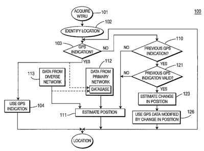
accordance with the present invention.
[0032] DETAILED DESCRIPTION OF THE PREFERRED EMBODIMENTS
[0033] The invention provides an extension of location detection and
location based services to a multi network environment where the user location
is
determined with greater accuracy due to new information being available, and
location information is shared across multiple networks to aid location based
-6-
CA 02557441 2006-08-18
WO 2005/081796 PCT/US2005/003920
services in one network using the location information obtained in another
network.
[0034] Location detection and location services are traditionally, defined
only in the context of a single network and single mechanism to determine the
user's location. This invention allows user location estimates from multiple
networks to be used together to get a better estimate of the user location, as
well
as sharing of the location information from one network to enable location
based
services in another network.
[0035] The present invention makes location estimation much more
accurate by making use of location estimates from multiple networks to
increase
accuracy of the estimate. Since there is more information available in the
case of
multiple networks more accurate estimation can be obtained. For instance,
location estimation in WLAN coverage can be accurate down to a few feet (a
meter), whereas the accuracy in UMTS is only accurate over several meters. If
the two networks shared this information, it would be possible to know where a
user is in UMTS system is down to a few feet.
[0036] Another benefit of the invention is that location information from
one network can be transferred to another and enable location based services.
[003'l] Figure 1 is a diagram showing the implementation of an exemplary
embodiment of the invention. A wireless radio network 11 includes a cellular
network controller 12, and a plurality of base stations 13, 16. A WTRU 21 is
able
to communicate with one or more of the base stations, such as base station 14
depicted in Figure 1. Typically communication is maintained by the WTRU 21
with a single one of the base stations except during handoff or other special
circumstances.
[0038] Local "hot spot" access points 27, 28 are also able to establish
wireless contact with the user WTRU 21. "Hot spot" access points 27, 28 are
wireless network services which typically have a range which is more limited
than that afforded by cellular base stations, but which are optimized for
providing high data rates. In some cases, "hot spot" access points 27, 28 are
_7_
CA 02557441 2006-08-18
WO 2005/081796 PCT/US2005/003920
integrated into the cellular network or are able to communicate with the
cellular
network.
[0039] Signals from the user's WTRU 21 are received by the cognizant base
stations 13 16, and values are received to indicate position information. In
addition to signals received from the base station 14 assigned to the user's
WTRU
21, it is likely that one or more of the base stations 13, 16 receive
sufficient signal
information to identify the user's WTRU 21. This information is combined with
information from the hot spots 27, 28 in two ways. First, the hot spots 27, 28
are
able to provide an indication of proximity of the WTRU 21 by signal strength.
This method is most effective for "hot spots" which are very localized, such
as
may be provided at a business for the business' customers. This information is
used by the cellular network controller 12 as an indication of possible
positions
for the WTRU 21. The WTRU 21 is presumed to be in a position which would
coincide with a signal strength measured by the "hot spot" access point 27.
[0040] Secondly, the "hot spot" access points 27 28 are able to provide some
location services, and thereby provide positional data. This method is most
effective in the case of hot spots intended for users in a large area, such as
several city blocks. A method of deriving location information by the hot spot
access point is to calculate the relative delay between the transmitted and
received signals and thereby infer the distance that the signal travels. This
gives
an indication of the distance of the WTRU from the access point.
[0041] The latter method is useful for combining the location services of
several networks. Thus, while competitive networks may or may not provide
connections to WTRUs within their coverage areas, such networks may be able to
provide location data to a network used by the WTRU for communications
services.
[0042] In the depicted case, the WTRU 21 communicates through base
station 14 to an extent necessary to identify the WTRU 21 as being within the
coverage area or cell of the base station 14. In addition, "hot spot" access
point 27
also communicates with the WTRU 21 to an extent necessary to identify the
WTRU 21 as being within the coverage area of the "hot spot" access point 27.
_g_
CA 02557441 2006-08-18
WO 2005/081796 PCT/US2005/003920
This information is certainly sufficient for the cellular network controller
and the
network associated with the "hot spot" access point 27 to determine that the
WTRU 21 is within the respective coverage areas. In some instances, the base
station 14 is also able to obtain location information concerning the WTRU 21.
[0043] The location information may be geolocation data provided by the
WTRU 21. A geolocation determination by the WTRU 21 is typically by use of a
GPS receiver in the WTRU 21, as will be described infra. The base station 14
may use positioning calculations such as TDOA calculations or other location
techniques to determine the position of the WTRU 21. If the base station 14
obtains geolocation data provided by the WTRU 21, this data is generally
considered accurate and further calculations would be unnecessary. In
practice,
however, geolocation data from the WTRU is often either unavailable or
intermittent. GPS data in particular is unavailable without a clear RF view of
several satellites. Often building materials and other environmental factors
will
block the satellite signals, and a clear RF view does not exist. For this
reason,
the base station 14 may augment GPS data with other location data.
[0044] According to the present invention, the cellular network controller
associated with a primary network obtains location data directly, and
indirectly
from a diverse network. This data from the diverse network is combined with
data obtained from the primary network. The cellular network controller then
combines the data in order to obtain a position estimate optimized by
inclusion of
data from both the primary network and the diverse network.
[0045] Information concerning the location data from the diverse network
may come directly from the diverse network, or may be stored by the cellular
network controller in a database 29. In many cases, the database 29 will
include
general information concerning the locations of one or more "hot spots" which
are
reception areas of the diverse network. This data can be obtained by using a
directory of "hot spot" locations, by querying the "hot spot" access point, or
by
historical data regarding coincidences between known locations of WTRUs
connected to the access points.
_g_
CA 02557441 2006-08-18
WO 2005/081796 PCT/US2005/003920
[0046] In the example shown in Figure 1, the primary network would
include base stations 13, 16, so that the data would be obtained by
information
obtained from base station 14. The diverse network would include "hot spots"
27,
28, and the cellular network controller would combine the information obtained
from base station 14 with information from "hot spot" access point 27.
[0047] The radio network is then able to use the information from all of
these sources to find the location of the emergency services number caller
directly, or alternatively to provide supplemental location information for
other
methods, (such as TDOA).
[0048] In many circumstances, a diverse network serving "hot spots" will
not have data available concerning the geographical locations of "hot spot"
access
points, or will only have generalized address data. To the extent that the
"hot
spot" access point can be identified by the cellular network controller 12
with a
known location of a WTRU, the cellular network controller 12 may include that
"hot spot" location to augment the database.
[0049] Figure 2 is a diagram showing a wireless network 41 according to a
modification of the present invention. As depicted in Figure 2, GPS or other
position data is enhanced by location data obtained by a combination of base
stations 43, 46 and a diverse network 47, 48. The user's WTRU 51 has a GPS or
other position location circuit 52. If the user's WTRU 51 is able to acquire
enough satellites, the user's WTRU 51 can accurately report its position to
the
cellular network controller 12. GPS data, represented by satellite 53 is
considered to be more accurate than data obtained from comparing signals
received by the diverse network 47, 48 or comparing signals received by the
base
stations 13, 16 from the user's WTRU 51 with signals received from the diverse
network 47, 48.
[0050] It is anticipated that the GPS data, while more accurate, will
frequently be unavailable. According to one aspect of the invention, when the
GPS data is unavailable, the information obtained by comparing signals from
the
user's WTRU 51 with the signals received by the diverse network 47, 48 will be
used to update the GPS data. In a particular embodiment, the information
-10-
CA 02557441 2006-08-18
WO 2005/081796 PCT/US2005/003920
obtained by comparing signals from the user's WTRU 51 with the signals
received by the diverse network 47, 48 is used to indicate positional changes
in
the WTRU 51, thereby modifying the GPS data primarily by adjusting the GPS
data in accordance with a sensed change, rather than generating new positional
information independently of the GPS data.
[0051] Information concerning the location data from the diverse network
is enhanced by the use of GPS data from WTRUs because in many cases data
concerning the locations of "hot spots" is not readily available to the
primary
network.
In instances where GPS reception is available during connection to a "hot
spot"
access point, data concerning the coincidence of the GPS data and the "hot
spot"
connection can be stored in the database 29. In this way, later connections to
the
"hot spot" access point can be presumed to coincide with the previously
reported
GPS data. This is significant because in many cases, most individual
connections
to a given "hot spot" will not include the availability of GPS data.
[0052] Figure 3 is a flow diagram 100 showing estimation of position in
accordance with the present invention. A WTRU is acquired by a primary
network or a diverse network (step 101) and in response, the acquiring network
attempts to identify the location of the WTRU (step 102). The identification
of
the location (step 102) can be initiated when the WTRU is acquired or delayed
until a further communication link is established.
[0053] A determination is made as to whether the WTRU can provide
positional information, typically based on GPS geolocation (step 103). If the
GPS
positional information is available, it is used (step 104). The determination
and
use of GPS data (steps 103 and 104) is given by way of example, and any
determination that location data of a predetermined accuracy can be employed.
[0054] If the GPS positional information is not available, as determined by
step 103, a determination is made as to whether a previous GPS indication is
available (step 110) and whether the previous GPS indication is valid (step
121).
Validity would depend on, time and movement, and concordance of the GPS data
with local position indications for the WTRU.
-11-
CA 02557441 2006-08-18
WO 2005/081796 PCT/US2005/003920
[0055] If a valid previous GPS indication is unavailable, an estimate of
position is made (step 111), using data provided by the primary network
(step 112) and data obtained from a diverse network (step 113). This can be
performed by the primary network independently of the diverse network as well
as by use of the diverse network. In the case of data obtained from the
diverse
network (step 113) database data provided by the primary network is used to
provide additional information. Given the circumstance in which the primary
network attempts to obtain location data, the WTRU is assigned to a particular
base station, and the primary network obtains data available from that base
station. Often the network is able to use data from neighboring base stations
in
addition to the base station to which the WTRU is assigned. The data from the
base stations of the primary network is resolved to the extent of the
capabilities
of the primary network for use in determining the location of the WTRU. In
addition, data is obtained from the diverse network. This data can be position
determinations which are deemed to have a particular accuracy. The data from
the diverse network is combined with the data from the primary network in
order
to obtain more precise location estimates of the WTRU. This diverse network
data can be obtained from multiple diverse networks.
[0056] The data from the diverse network can vary from general
information that the diverse network is able to identify the WTRU within its
coverage area to data concerning specific location within a particular access
point
of the diverse network. The accuracy of the data and the ability of the data
to
limit the possible position estimates made by the primary network must then be
determined. In one embodiment, the data from the diverse network is itself
self
limiting. The primary network can then combine the data with data directly
obtained by the primary network, by use of a database. For example, if the
diverse network has a specific geographic coverage area within which WTRUs
can be identified, the data from the diverse network is that the WTRU is
within
that geographic area. On the other hand, the diverse network may provide
specific position estimates. The position estimates may include precision data
or
precision data may be separately obtained. The data from the diverse network
-12-
CA 02557441 2006-08-18
WO 2005/081796 PCT/US2005/003920
can be compared with data associating that data with further data. Further
data
can include geographical location data, a database associating signal values
with
possible locations, a predetermination of the accuracy of location data
obtained by
the diverse network, and an association between position fixes or values
provided
by the diverse network with location determinations of known accuracy.
[0057] In the case of ambiguity, it is a matter of design choice as to which
data is accepted as true. It is possible to obtain some verifications of
position, for
example by obtaining GPS location readings and comparing the GPS reading to
the estimate. These verifications can be used to provide corrections to future
position estimates.
[0058] If a previous GPS indication is determined valid (step 121), an
estimation of a change in position is made (step 123). This can be performed
by
the primary network independently of the diverse network, by use of the
diverse
network, or by the primary network using data from the primary network in
combination with data from the diverse network. The estimation of change in
position is then used to modify the reported GPS position, so that the
reported
position is based on the GPS position (step 126), and not solely by an
independently generated position estimate.
[0059] The validity of a previous GPS estimate may be modified by the
availability of rate sensing data from the WTRU, as represented by the dashed
lines in the diagram. To the extent that the rate information is deemed to be
more reliable than change in signals received by the diverse network, the rate
information is considered when determining the validity of the GPS data.
[0060] If the WTRU provides the user with GPS based navigational data,
the network can update the GPS data according to the determinations made by
the network regarding location. This provides the user with a continuation of
GPS based navigational data in instances where the GPS data may be
intermittent.
[0061] It is possible to combine GPS data with data from the primary and
diverse networks in a manner which permits the diverse network to augment or
substitute for the GPS data when the GPS data is unavailable. The GPS data is
-13-
CA 02557441 2006-08-18
WO 2005/081796 PCT/US2005/003920
received from the user's WTRU during times of availability of the GPS data,
thereby providing primary location data concerning location of the user's
WTRU.
Location data from the diverse network is used during times of unavailability
of
the GPS data, thereby providing secondary location data concerning location of
the user's WTRU. This permits the GPS data to be used as primary location
data, while using the diverse network, the primary network or a combination of
the diverse network and primary network to make correction adjustments. This
allows the use of the GPS, while providing continuity of location information
of
the user's WTRU by combining the location data from the GPS with secondary
location data.
[0062] The above descriptions include the use of a primary network and a
diverse network. The diverse network can include "hot spot" access points
administered by the primary network or "hot spot" access points or other
access
points administered independently of the primary network. The diverse network
can also be different network services such as an analog network or a network
which permits "roaming" off network by users. The location service can be
performed by the diverse network as well as by the primary network, and in
particular this will occur if a user engages emergency services while in a
"roaming" mode. In the case of the location service being performed by the
diverse network, the functions described above in association with the primary
network can be performed by the diverse network, with the functions described
above in association with the diverse network performed by the primary network
or by another diverse network.
-14-
CA 02557441 2006-08-18
WO 2005/081796 PCT/US2005/003920
[0063] In concept, the above descriptions include the use of a wireless
network controlled by a cellular network controller and a locally controlled
network which includes one or more access points (APs). The APs may be
administered by the cellular network controller or administered independently
of
the cellular network controller, but behave as independent groups of one or
more
radio interfaces. Data from the networks are combined in order to provide
increased accuracy in determining location of WTRUs. Further location data,
such GPS data, may be used to obtain location of the user's WTRU independently
of the networks and is combined with data obtained by using the locations of
transceivers associated with the locally controlled network and location
information obtained from the wireless network controlled by the cellular
network controller. This provides continuity of location information of the
user's
WTRU by combining the primary location data, for example from the GPS, with
the secondary location data.
[0064] Although the features and elements of the present invention are
described in the preferred embodiments in particular combinations, each
feature
or element can be used alone (without the other features and elements of the
preferred embodiments) or in various combinations with or without other
features and elements of the present invention.
* * *
-15-