Note : Les descriptions sont présentées dans la langue officielle dans laquelle elles ont été soumises.
CA 02662810 2009-04-17
-1-
This application is a divisional of co-pending
application No. 2,163,215.
Technical Field
The invention is a portable information system which
uses Global Positioning System (GPS) data as a key
to retrieve audio visual information from a database
or broadcast. It should be understood that the
expression "the invention" and the like encompasses
the subject matter of both the parent and the
divisional applications.
BACIORMIND TO TKR iNVENTION
Almost everyone who travels needs information about
the place they are visiting. However, we all have
different needs and interests, some need commercial
information, others may wish.to buy ft product, some
people like to know the history of a place, or to
discover hidden corners, others are simply bored and
long for their journey to be made more interesting.
As databases grow in size Do the problem of finding
relevant data when it is needed becomes more
difficult to solve. Few people have the time,
motivation or patience to search through telephone
books, yellow pages, guide books, information
systems and the like. Having taken a long trip it is
often only on returning hone when one learns too
late what has been missed. Even when at home it can
be difficult to find out what is happening in the
area today which might be of interest.
When walking, driving, sailing or flying our need
for information remains, although our ability to
= search for it may be severely limited by the task in
hand. We frequently need to switch modes of travel
between car/aircraft/boat/bus/horseback or foot.
Most portable GI'S receivers on the market today are
= designed for navigation, giving the user's position
in terms of latitude and longitude or bearing and
distance from a known point, both methods are
cumbersome to use. Although GPS moving map displays
show positions more clearly, their applications
remain rather limited, due to the need for a screen
and the risk of distraction when walking or driving.
Both types of GPS system offer the user little other
' information.
Talking books using CD-ROM disks may provide the
information lacking in the above mentioned
navigation systems, however as the location of the
user is not monitored automatically, any information
must be extracted manually by the user, which can be
laborious.
Mk 02662810 2009-04-17
-2-
Portable computers and pen computing systems provide
essentially text based information on the move.
However,' neither offer user friendly, hands-free,
eyes-free operation with automatic, dynamically
retrieved audio (and video) data based on the users
position, altitude, attitude, speed, time, direction
of view, stated needs and interests. It is not easy
to use such a portable PC when walking or riding on
horseback.
THE INVENTION
CPS EXPLORER is a portable information system using
Global Positioning System (GPS) data as a key to
retrieve audio and video from a database or from
broadcast data. The user may preselect the type of
data of interest to him, then as his position,
direction, speed, altitude or attitude change and
the time of day changes,' this is detected by the GPS
receiver and the system automatically retrieves the
appropriate data from the database. The device
incorporater. an internal exchangeable database on
compact disk and can also access external databases
and broadcast data.
GPS Explorer is desighed to provide information on
the move. In most of the applications envisaged the
user has little need to know his location, simply
wishing to be told about places of interest to him
such as the history of a nearby building or where to
buy a product. The fact that the information the
User requires comes from a device which uses GPS
position, speed, altitude or time as a key to access
a database need not concern the user or be apparent.
To enable the user to operate the system hands-free
and eyes-free while driving, flying, sailing, riding
or walking, it may be controlled using audible menus
and voioe command. Telephone calls may also be made
automatically via an integrated cellphone or
satellite phone using numbers retrieved from the
'database.
On a journey the system can for example be set to
SO automatically identify places of likely interest to
the user, to describe the history of nearby
buildings or the prettiest route to take. The user
can also initiate an automatic search of the
database for specific things of interest to him,
such as landmarks, hotels, hospitals, shops or
produots, usually, though not necessarily, within a
radius of his present position.
CAB, 02662810 2009-04-17
-3-
The basic device is a portable audio Information
system which US88 GPS data as a key or keys to
retrieve digital audio from a database contained
within the device or attached to it by any means or
received by any means including telephone, radio or
television broadcast.
When equipped with or attached to a screen, the
device may also include the facility to retrieve
still and motion video sequences from a database
contained within or attached to the device by any
means or received by any means including telephone,
radio or television broadcast. When connected to a
display, the system may also be used to preview
trips.
The system can provide GPS positioned simulations
using virtual reality displays. The GPS derived
position, elevation, viewing direction and time of
day, enables simulated structures, buildings, dams,
roads and landscape features to be dropped into the
users field of view and to be examined from all
angles around the proposed site while it is still
virgin territory.
The device constantly monitors it's position, speed,
direction of movement, the time and any like data by
reference to a GPS receiver either incorporated
within the device or connected to it by any means.
Whenever the device-detects a ,change in any GPS
parameters, such as a change in location or time, it
will use the new GPS data as a key or keys to search
the database including received broadcast data and
retrieve any data records which directly or
indirectly match or relate to the new GPS
parameters. Before being output as audio or
displayed, the retrieved data will be checked
against the mode of operation of the device and
against other selection criteria, to determine
which, if any, of the retrieved data items are to be
presented to the user. A rolling log of messages
will be kept to avoid needless repetition.
The device may be controlled by voice command or by
keyboard, switch or joystick, directly or remotely.
The user may select the mode of operation of the
device, data retrieval criteria and other operating
criteria.
The device has an audible menu system which when
= Used with voice command, enables the device to be
used hands free and eyes free. Feedback protection
avoids the audio output triggering the voice input
system.
CA 02662810 2010-12-06
-4-
The device may be fitted with a telephone interface enabling telephone calls
to be placed to numbers retrieved from the database or broadcast data. The
device may also be fitted with an interface for the attachment of optical,
magnetic, radio or other devices capable of inputting data for the purpose of
identifying location, products, persons, vehicles, systems, temperatures or
any environmental variables.
The device determines user orientation, direction of movement, speed, pitch
and role, altitude, rate of climb or descent, and the user's direction of view
in
terms of bearing, angle of azimuth and range. The system can also accept
optical or other inputs to identify locations within buildings, which would
otherwise be out of GPS reception.
According to the first aspect of the invention there is provided a personal
information system comprising a global positioning receiver for generating
global positioning (GPS) data indicative of a current location of a local
user,
means for generating a user message for transmission to a remote recipient,
means for incorporating the GPS position data into the user message so that
the remote recipient knows the location of the local user, and means for
wirelessly transmitting the user message to the remote recipient.
According to the second aspect of the invention there is provided a method of
communicating wherein a remote recipient knows the location of a local user,
comprising generating global positioning (GPS) data indicative of a current
location of the local user, generating a user message for transmission to the
remote recipient, incorporating the GPS position data into the user message
so that the remote recipient knows the location of the local user, and
wirelessly transmitting the user message to the remote recipient.
According to the third aspect of the invention there is provided A personal
information system comprising a global positioning receiver generating global
positioning (GPS) data indicative of a current location of a user, a database
of
characteristic data items associated with points at predetermined locations
within a geographic area, and means for generating a message associated
CA 02662810 2014-02-12
- 4a -
with a characteristic data item associated with a particular
point when the current location of the user corresponds to
that particular point.
In another aspect, the invention provides a personal
information system comprising a global positioning receiver
and a radio positioning receiver, together for constantly
monitoring positioning data to determine a current location of
a local user, means for generating a user message for
transmission to a remote recipient, means for incorporating
the position data into the user message, means for wirelessly
transmitting the user message to the remote recipient, and an
interface for inputting data identifying products, persons,
vehicles, systems, temperatures, environmental variables or
desired location.
In another aspect, the invention provides a method of
communicating wherein a remote recipient knows the location of
a local user, comprising constantly monitoring global
positioning (GPS) data combined with radio positioning data,
together determining a current location of the local user,
generating a user message for transmission to the remote
recipient, incorporating the GPS position data into the user
message so that the remote recipient knows the location of the
local user, wirelessly transmitting the user message to the
remote recipient, and inputting data identifying products,
persons, vehicles, systems, temperatures, environmental
variables or desired location.
In another aspect, the invention provides a personal
information system comprising a global positioning receiver
combined with radio positioning receiver, together for
constantly monitoring positioning data to determine a current
location of a user, a database of characteristic data items
associated with points at predetermined locations within a
geographic area, and means for generating a message associated
with a characteristic data item associated with a particular
point when the current location of the user corresponds to
that particular point,
wherein the database of characteristic items is stored
remotely, and the data is retrieved by a wireless connection.
CA 02662810 2012-04-04
- 4b -
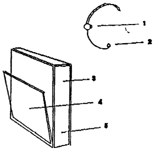
DESCRIPTION OF PREFERRED EMBODIMENTS
1. An audio only version of the design will now be described by
references to the accompanying drawings.
Figure 1 shows the audio only version of the device comprising: audio
earpiece 1, microphone 2, the GPS receiver 3, the CD drive 4 and the
processor 5.
Figure 2 shows the basic logic used to monitor the user's position and to
retrieve and play the appropriate audio.
Figure 3 shows a map on which large dots represent the positions determined
by GPS at which specific audio phrases will be selected from the database or
radio broadcast and played. Samples of typical audio phrases are numbered
1-6.
The GPS latitude/longitude co-ordinates of places of interest such as historic
buildings, castles, villages, parks, lakes, mountains, panoramic viewpoints
and so forth may be digitized from maps or by on site survey. Audio
describing each place of interest will then be recorded and stored, in
compressed form, with corresponding GPS co-ordinates, in a database on a
compact disc (GPS-CD)
The portable GPS Explorer may then be used with such a GPS-CD database
to provide information to the user who may select one or more of the device's
many modes of operation, such as for example:
En Route mode:
Figure 3 shows a typical journey by car along a major road. By constantly
monitoring GPS data, the device will determine when each of the locations 1-6
has been reached, the corresponding audio phrase will then be retrieved from
the GPS-CD database or broadcast data and played to the user through an
earpiece or loudspeaker.
CA 02662810 2010-12-06
=
-5-
There may be several locationa at whioh broadly
similar. messages would be. applicable, .such as
approaching a village from the North, south, East or
i0 West. In this case, the appropriate audio messages
may be.asseebled from several phrases with variables
such. as left and right inserted as deterMined by
.
user orientation, thus enabling More economic use to
be made of available database space.=
Tour mode.
The user may select a.tour either from the main menu
or when offered the option en route. The system will
then provide tour guidanoo and point out things of
intereet. For example when walking or driving past
historic buildings or other features information
about each building will be given. It's date of
construction, who lived there, how it was built, if
it is open to the public. The dialogue may include
historic aounds, the crack of a coachman's whip, the
voices of children at play, music drifting on the
air, all creating the atmosphere of a bygone age. -
Hazard Warning Node.
=
If this mode has been selected it will take priority,
over other modes 341 use at the time such as tour
mode. When approaching a hazard the system will
interrupt any other audio message to' alert the user.
For example in road Use a dangerous bend, a school
or a steep hill. In flying mode to warp of
controlled airspace.
Guidance mode.
The GPS.lat/long location of a road junction will be
digitized and audio recorded for each direction of
approach to each unotion. The device will identify
the users position and direction of travel on the
approach to ft junotion by reference to GPS data and
'then retrieve the appropriate audio in advance of
the junction to act as an audio signpost. The audio
Signpost Will net be restrictea-r07just place names
=
as it may include much more information about road
type, places of interest en route, warnings such as
no fuel for 50 miles and so on.
Destination oriented guidance mode. =
. 55
When this Mode is first selected the user will be
prompted to choose a destination. A route from the .
present position to the destination will be
Mk 02662810 2009-04-17
-6-
determined from routing data. The device will then
provide only the single direction needed at each
junction to reach the destination without referring
to unwanted directions.
What's on mode.
The device will examine the co-ordinates of all the
specially -identified places of interest in the
immediate area, gradually working out from the'
present GPS location. The device will then play a
short audio phrase for each activity to briefly
arouse the interest of the user. The user may then
select any activity and obtain further details for
deliberation, after which GPS guidance will be
provided to the venue on request. An auto dial
telephone number may be added for use via the
telephone interface, to enable reservations to be
made for hotels, theatres or similar venues without
the need to write down then dial the number.
Walking mode v Driving Mode v Flying Mode, etc.
The system will adjust the presentation of messages
to suit the mode of travel selected by the user and
the GPs calculated speed. For example, when walking
slowly around a town the user will be given more
detail than when driving through the town or flying
overhead.
=
Application specific modes
Certain applications may require a special mode of
operation to focus the users attention on certain
data, for example:
= 40 Walking tours in open country
A map provides only limited information, whereas by
using a walks database GPS Explorer can provide
orientation, directional guidance and can identify
landmarks by name. It can also keep the casual
walker entertained with a poem or music or a
description of the view at the appropriate point on
the walk. A group may share the audio with personal
radio earpieces without the need for wire connection
or noise pollution from a loudspeaker.
The system will orientate the user by compass
bearing or turn left/right command enabling the user
to be directed to a pathway or to safety. By
pointing the device at a hill for example the system
will retrieve the name of the hill, it's height and
any hazards such as cliffs.
CA 02662810 2009-04-17
=
-7-
With a database of walks, giving distances and times
the system will calculate from the present GPS
position and time if the number of hours of daytime
left are sufficient for the selected walk to be
completed safely.
In an emergency, a distress call can be made vja
cellular or satellite phone, incorporating GPS
position data into the audio message to aid rescue
services.
General Aviation Application.
Having selected general aviation mode for example,
the system will identify the users GPS position,
altitude and speed in relation to aviation related
points such as airports, restricted areas, danger
areas, light aircraft routes, air traffic control
boundaries and so forth. The device will then
provide the pilot with audio guidance, airspace
alerting or an information retrieval by voice
command, accepting pilot response by voice command
or in noisy cockpits by press button.
Call ahead
To find a telephone number when on the move can be
difficult. This system provides several facilities
which will help. In any mode the user has access to
an audible facilities menu, providing a list of
hotels, airlines and so on. When a selection has
been made by the user, the system will automatically
dial the telephone call using the telephone number
held in the database.
The system Uses CPS position, direction of travel
and the user's pre-determined preferences to order
the possible alternatives into a logical sequence
for presentation to the user. For example, ir the
user is heading South at high speed by road, prefers
a 4 star hotel and payment by AMEX the alternatives
will be reduced. They will then be ranked in
distance from present position. The system will then
retrieve the correct telephone number ready for the
user to request auto-dial telephone call for room
reservation.
The system will also hold the users preferred credit
card detaile on file avoiding any need to retrieve
the card from a pocket while driving or flying. On
= the telephone, the user needs only to say "my AMEX
number is" and the system will retrieve the card
number data and finish the sentence for the user eg
"1234 3456 567 expiry date 0695".
CA 02662810 2009-04-17
-8-
En route advertising could also be inserted into
tours at specified points to provide the user with
the facility to call ahead to reserve a table for
dinner, order flowers, to book a hotel room or
reserve a ferry epaee,
Audio Commands
The device may be controlled by audio commands,
chosen by the user, to perform a range of basic
information storage and retrieval functions. The
35 user will need to select commands which he/she is
comfortable with. Examples of these are given below;
Menu - plays the main menu
OX - eelects the last option stated
Repeat - replays the last audio phrase
X Mode - selects a specific mode
Stop - stops the audio
Start - starts the audio
Earpieee - switches to earpiece
Speaker - switches to loudspeaker
Skip - skips the present audio phrase
Position - gives position from...
Diatance - gives distance from start, to...
Log on - starts a log of position data
Log off - stops log
;1 An audio visual versien of the design will now be
described by reference to the following drawing:
Figure 4. shows a version of the audio/visual system
based on a standard portable Pc. Still and/or motion
video sequences will be stored on GPS-CD along with
the CPS 0o-ordinates described in the audio example
above. This visual data can then be accessed in
several modes;
Pre-view mode:
Before visiting a remote location, the user may use
the device to pre-view the various places he intends
to visit. Any visual sequences may be retrieved and
played simply by entering the name or lat/long of
the desired place or by selecting it from a list
given by the system.
More detail mode:
In an audio mode, once audio details of a venue have
been given by the system the user will be notified
by a bleep or prompt if pictorial information is
also available from the database. The user may then
select it if required.
CAB, 02662810 2009-04-17
-9-
Simulation mode:
Having arrived at a physical location or identified
it in pre-view mode, the user may access the
database to obtain a computer based simulation of
some aspect of the location. For example to see the
route of a proposed new road or the simulated facade
of a proposed new building. ny walking around the
physical site, as the GPS data changes BO will the
simulation to illustrate the simulated views from
the new physical position taking into consideratiOn
the users orientation, height, direction of view,
view angle of azimuth and time of day. The
simulation may be presented on a display ecreen or
any form of image projection system such as a
virtual reality helmet or other device. If used in
conjunction with a head up display the user will
have both the present image and simulated future in
view simultaneously enabling comparison.
2. A real time version of the device will now be
described.
To enable the user to have access to up to the
minute information the device incorporates a radio
or television receiver to receive specially
broadcast regional data transmissions. The system
selects incoming data relevant to the chosen mode of
Use and location based on On calculated position.
Selected data items are stored in memory in the
device on receipt and then handled in the same way
as other database data described earlier.
The real time data system could provide the user
with access to and automatically search a wide range
of information sources: local weather, weather
reports for pilots and yachtsmen, scheduled flight
delays details of special events, hotel room
availability, road conditions, audio guided
diversions, financial market updates for example.
4. A virtual reality version of the device will now
be described.
=
Virtual reality is a term used to describe a
computer generated three dimensional image which
when observed using a special form of projection
'system or helmet, creates the illusion of reality
and allows the user to move through it and to react
with computer generated objects.
This invention combines the real world image with
computer generated images. The device obtains it's
real world frame of reference from it's GPS
position. This allows the device to generate virtual
Mk 02662810 2009-04-17
-10-
objects so they are oorrectly located within the
observers real world. The resulting oomputer
generated image may then be projected into the users
field of view ueing split image spectacles.
Alternatively the computer generated objects may be
overlaid on a video picture of the real world and
the resulting- composite bulge projected for an
= observer wearing an artificial reality helmet.
The device enables a fire or rescue crew visiting
= say an oil rig to superimpose structural, electrical
or hazard data onto their real world view of the
structure, giving them safety related information
and audible hazard alerts.
The device would also enable a user visiting the
site for a new building to see the computer
generated image of the new building superimposed in
tho landscape. The computer generated image will
change as the user's GPS position changes when he
walks around the site.
COMMERCIAL EXPLOITATION OF THE INVENTION
Revenue can be generated from sales of the GPS
Explorer units, application CD's and real time
services.
Sales of GPS Explorer CD's are expected to provide
the greatest growth potential as the range of
potential applications for the system is almost
unlimited. Each new application will require
companies around the world to produce new CD's for
their market. Many Explorer CD's will incorporate
details of the businesses in an area, rather like an
interactive version of Yellow Pages. But unlike
Yellow Pages who leave customers with the problem of
= finding the advertisers premises, the GPS Explorer
system leads the customer to the advertiser, even if
= their premises are difficult to find, it will even
dial the number automatically to enable the user to
check requirements before going there.