Note : Les descriptions sont présentées dans la langue officielle dans laquelle elles ont été soumises.
CA 02973038 2017-07-05
Description
COMBINED INERTIAL NAVIGATION AND LASER SCANNING COAL SHEARER
POSITIONING DEVICE AND METHOD
Field of the Invention
The present invention relates to a coal cutter positioning device and a method
thereof, in
particular to a coal cutter positioning device integrating inertial navigation
with laser
scanning and a method thereof.
Background of the Invention
The positioning technology refers to the technology used to make measurement
on the
target by adopting various measures and in turn to acquire the target position
information.
With the continuous improvement of modern technologies, the positioning
technology
enjoys increasingly higher status in production and life. In many technical
fields of
positioning, the positioning of different types of equipment under the mine is
gradually
drawing attention. Due to the frequent occurrence of mine safety accidents and
serious
disasters, the positioning of mining equipment has become particularly
important. This is
also a prior condition for automation and safety in production. During the
mining of coal
resources, the coal cutter is one of the important equipment for underground
work.
Therefore, the positioning of the coal cutter is particularly important.
However, due to the
special conditions under the mine and the complexity of underground
environment, many
commonly used positioning means fail to meet the requirements for positioning
accuracy,
and even fail to determine the position of the coal cutter under the mine. In
this context,
the progressive development of technologies such as inertial navigation
positioning and
laser scanning positioning has made it possible to realize the exact
positioning of the coal
cutter.
The traditional calibration modes for the coal cutter often fail to realize
accurate
calibration, due to the existence of inherent error. At present, the coal
cutter positioning
methods commonly used under coal mine environment mainly include gear counting
method, infrared shooting method, ultrasonic reflection method, wireless
sensing
network positioning method and pure inertial navigation method. The coal
cutter gear
counting positioning method is designed to count the rotation turns of the
gear in walking
part and position the coal cutter according to the hydraulic support. This
method is
relatively simple in use and low in cost. However, since the coal cutter
performs
transverse and longitudinal movement along the working surface in the
operating process,
while the gear counting method can only determine the walking distance of the
coal
cutter, leading to inaccurate positioning and major error. For the application
of infrared
shooting positioning method, an infrared emission device is installed on the
machine
body of the coal cutter, and an infrared receiving device is fixed on the
hydraulic support.
In the operating process of the coal cutter, this method makes analysis on the
intensity of
the signals received by the receiving device and thus judges the specific
position of the
coal cutter. As for the disadvantages of this method, it cannot continuously
detect the
position of the coal cutter, at the same time, the emission and receiving of
infrared signals
must be realized in the same horizontal plane, otherwise it is very difficult
to receive
CA 02973038 2017-07-05
signals effectively. Therefore, in the actual underground mine environment,
this method
often fails to realize accurate positioning due to numerous interference
factors. The
wireless sensing network positioning method is designed to determine the
position of the
coal cutter through WIFI, ZIGBEE. UWB or Bluetooth technology. This
positioning
method is generally limited by instable positioning system, immature technical
research
and excessively high costs, and thus cannot be used in underground
environment. The
pure inertia positioning method is designed to use acceleration meter and
gyroscope to
obtain the axial acceleration and axial angular speed of the coal cutter, and
determine the
position of the coal cutter through algorithm. Due to the drift existing in
the gyroscope
and the acceleration meter, there is continuous increase in cumulative error.
Therefore, it
is very difficult for this method to ensure the positioning precision, and it
is impossible to
realize the absolute positioning of the coal cutter.
To sum up, the existing coal cutter positioning methods, including gear
counting method,
infrared shooting method, ultrasonic reflection method, wireless sensing
network
positioning method and pure inertial navigation method, still involve major
error in the
positioning of the coal cutter under coal mine environment. Generally being
limited by
the detection mode itself and the influences of underground coal mine
detection
environment, these methods fail to meet the accuracy requirements in the
positioning of
the coal cutter.
Content of the Invention
Technical problem: in order to overcome the deficiencies in the prior art, the
prevent
invention provides a coal cutter positioning device integrating inertial
navigation with
laser scanning and a method thereof The present invention can realize the
exact
positioning of the coal cutter, and thus solving the problem of continuously
increasing
cumulative error in the case that the inertial navigation is simply adopted
for positioning.
Technical solution: in order to achieve the above-mentioned objects, the
present invention
adopts the following technical solution: a coal cutter positioning device
integrating
inertial navigation with laser scanning and a positioning method thereof. The
coal cutter
positioning device comprises a coal cutter, an inertial navigation positioning
device, a
laser scanning device, a positioning device explosion-proof enclosure and an
upper
computer; the positioning device explosion-proof enclosure and a laser signal
receiving
module of the laser scanning device are fixed on the machine body of the coal
cutter; the
inertial navigation positioning device is installed in the positioning device
explosion-proof enclosure.
The inertial navigation positioning device comprises a three-axis gyroscope, a
three-axis
acceleration meter and an inertial navigation microprocessor; the three-axis
gyroscope
comprises a three-axis gyroscopic sensor; the three-axis acceleration meter
comprises a
three-axis acceleration sensor. During the operating process of the coal
cutter, the inertial
navigation positioning device determines the real-time angular rates in three
directions
through the three-axis gyroscope, determines the real-time acceleration values
in three
directions through the three-axis acceleration meter, and samples the data
measured by
the three-axis gyroscopic sensor and the three-axis acceleration sensor to the
inertial
navigation microprocessor; the inertial navigation microprocessor is connected
with an
upper computer through a serial port.
2
CA 02973038 2017-07-05
The laser scanning device comprises a laser scanning base station, a laser
signal receiving
module and a laser scanning microprocessor; the laser scanning base station is
arranged
in the working area of the coal cutter; the laser scanning microprocessor is
installed in the
positioning device explosion-proof enclosure; the laser signal receiving
module is
connected with the laser scanning microprocessor, the laser scanning
microprocessor is
connected with an upper computer through the serial port and transmits the
laser scanning
positioning data to the coal cutter positioning control system in the upper
computer; the
laser emitted by the laser scanning base station is received by the laser
signal receiving
module on the machine body of the coal cutter, and the received time
information is
acquired and processed by the laser scanning microprocessor; the upper
computer makes
judgment of the data information, and adopts the fusion algorithm (the least
square
method is adopted for determining the weight value of coefficients, and the
neural
network algorithm is adopted for evaluating the positioning) to finally
determine the
position of the coal cutter and realize accurate positioning.
A coal cutter positioning method comprises the following steps:
A. A positioning device explosion-proof enclosure is installed and fixed on
the machine
body of the coal cutter, so that the whole inertial navigation positioning
device is
installed in the explosion-proof enclosure; the positioning device is designed
to
respectively determine the real-time angular rates and real-time acceleration
values
in three directions through the three-axis gyroscope and the three-axis
acceleration
meter, send the measured values to the inertial navigation microprocessor. and
obtain
the coal cutter positioning results measured by inertial navigation through
algorithm
resolution;
B. The laser scanning base station is arranged in the working area of the
coal cutter, the
laser signal receiving module is installed on the machine body of the coal
cutter, and
the laser scanning microprocessor is fixed in the explosion-proof enclosure,
so that
the coal cutter positioning by laser scanning is realized.
C. The inertial navigation microprocessor and the laser scanning
microprocessor are
connected with the upper computer through the serial port data communication
is
established, the coal cutter positioning results obtained through resolution
are
transmitted to the coal cutter positioning control system of the upper
computer
respectively, so that the data interaction is realized;
D. In the coal cutter positioning control system of the upper computer, a coal
cutter
positioning model is established according to the actual working area and the
arrangement of devices: the model comprises a laser scanning system and an
inertial
navigation system to realize the classification of positioning data, a
three-dimensional location co-ordinate for accurate measurement of the laser
scanning base station is input to the laser scanning system and a co-ordinate
for
accurate measurement of the initial position of the coal cutter is input to
the inertial
navigation system;
E. When the coal cutter is in normal working, the coal cutter positioning
system is
operating.
The said step B comprises the following steps:
3
CA 02973038 2017-07-05
BI. The laser scanning base stations are arranged according to the present
operating
environment of the coal cutter. According to the principle that each point can
be
scanned by more than two base stations during the operating process of the
coal
cutter, and taking account of the cost of base stations, three base stations
are arranged
to realize positioning;
B2. Three laser signal receiving modules are installed on the machine body of
the coal
cutter to realize the receiving of laser signals; the laser scanning
microprocessor in
the explosion-proof enclosure is connected with the laser signal receiving
module
through the serial port, so that the reading of data is realized;
B3. The laser scanning microprocessor comprises a signal threshold setting
part, since
the laser signals are susceptible to dust and shelter, the microprocessor does
not
perform data resolution when the intensify of laser signals is relatively low
and is
unable to meet the requirements for signals required by positioning; the
signal
threshold is set as 6, when the intensity of received signals is bigger than
6, the
microprocessor performs the positioning data resolution and resolves the coal
cutter
position information through algorithm.
The said step E comprises the following steps:
El. When the coal cutter is in normal working, both the inertial navigation
system and
the laser scanning system operate normally, since the signal threshold
judgment is
made in the laser scanning microprocessor, when the signal intensity meets the
requirement for laser scanning, the coal cutter positioning data provided by
both
systems is sent to the fusion algorithm for optimizing; when the signal
intensity fails
to meet the requirement for laser scanning, only the inertial navigation
positioning
data is adopted as the coal cutter position information;
E2. On the assumption that the inertial navigation system positions the
location of the
coal cutter as(xi Yi z1), and the laser scanning system positions the location
of
the coal cutter as (x2 , Y2' z2), according to the present detecting
condition,
assign weight coefficients a, b, namely, the position coordinates of the coal
cutter
(x, y, z):
(x, y, z)-= a(xl, y,, zi)+ b(x2, y2, z2)
Meanwhile, the coefficients meet: a + b = 1;
E3. The assigmnent of weight coefficients is determined by the least square
method, and
artificial neural network algorithm is adopted to evaluate the assigned
coefficients
and positions to finally realize the positioning of the coal cutter;
The principle of least square method: on the assumption that there is a
function:
Pn(x)=(x y, z) = a(x1 Yi, zi) + b(x2 , y2, z2)
= ax n + afl1x + === + aix + ac,
wherein, a0, a1, a., are coefficient constants, /Mx) s an expanded
polynomial,
then he assumed array is 1(xõ = 1, 2.- , Inj
4
CA 02973038 2017-07-05
Select the constants a , a.õ, so that
the variance is minimized, namely,
-= XT-16 ¨
Wherein, S represents the variance, in order to minimize S and the coefficient
constants meet at,, ai, 0, then
determine the polynomial&(x), and in
turn obtain the weight coefficients a. b;
Artificial neural network algorithm: according to the actual requirements for
positioning of the coal cutter, the coal cutter fusion positioning system
neural
network model is established, in which the input layer is two positioning
coordinates
assigned with weight values, namely, the input layer vectors P as follows:
P ¨ Ea(xaN y z1) 17(Xz % y2 z2)]
Input layer 0 is the desired coal cutter position coordinate, namely:
= kxy 41
-
According to the empirical equation L = Nr1r, n + c, wherein, rn represents
the
number of nodes of the input layer, n represents the number of nodes of the
output
layer, and c represents a constant within 1-10, L represents the number of
nodes of
the hidden layer; the number of nodes of the hidden layer is selected as 3,
the model
is established according to the requirements of the neural network algorithm;
PI represents the input of the ith node of the input layer, j=1,2;
represents the
weight value between the ith node of the hidden layer and the jth node of the
input
layer; Oi represents the threshold of the node of the hidden layer, D(x)
represents
the excitation function of the hidden layer; wi represents the weight value
between
the output layer and the ith node of the hidden layer, 1=1,2,3; T represents
the
threshold of the output layer; yo(x) represents the excitation function of the
output
layer; 0 represents the output of the output layer; for 0r,x), it is generally
determined as sigmoid function having continuous value range within (0,
0(x) ¨ - = for (p(x), in general adopting purelin function, selecting 07(x) =
k x,
then
(1) The forward propagation process of signals
The input of the ith node of the hidden layer nett: net, = wP1 +w?, + 0,; the
output
of the ith node of the hidden layer yi; yi = 0(.11E2P2. + wizP2 +@); the input
of the
output layer net: rtet = 0(wtiP1 + wt,P, + Gi) + r; the output of the
output
layer 0: 0 =q4,,E,wi +wi2P2 + 6 i) r);
(2)The back-propagation process of errors
5
CA 02973038 2017-07-05
For each input position information, on the assumption that there is only one
group
of samples for each time, the error function is defined: E = (T Q)2, wherein,
T
refers to the expected output value, E represents the magnitude of the error
value;
According to the principle of gradient descent of error, the equation of the
output
layer weight variation Attri :
AVVi =, -17 = ?KT 0) = 4:p(n et)= yi; the adjustment equation of the
àErt
output layer threshold variation Ar: 11T = -y 7 = " = ?KT ¨ 0) - tp(n. et);
the
adjustment equation of the hidden layer weight value variation Awif:
Aw,3 = ---= ri(T - 0) = 99(net)= wi = 0(net,) = PG; the adjustment
equation of the hidden layer threshold variation
= = -n a+dn., = ira - cp (net), vvi = 10(ne t,);
Finally, through network optimization, the coordinate vectors of the coal
cutter
0 = [(Ix y 2)1 are output;
E4. After the algorithm processing, the coal cutter positioning result is
input to the
inertial navigation microprocessor through the serial port, and the coal
cutter
positioning result will be adopted by the inertial navigation microprocessor
unit as
the initial value for the next position resolution, at the same time, the
positioning
results are provided in the coal cutter positioning model;
E5. When the coal cutter is operated to the terminal position, it is in the
out-of-operation
status, then the inertial navigation system stops operating, and the laser
scanning
performs repeated measurement for many times, after the fault data is
eliminated, the
minimum circumscribed circle algorithm is adopted to obtain the position of
the coal
cutter, and this position result is assigned as the initial value of the coal
cutter
position in the inertial navigation system; the coal cutter continues
operating and E1¨
E4 is repeated.
The present invention provides the following beneficial effects. Since the
above-mentioned solution, the coal cutter positioning device and the method
are
adopted, such that the inertial navigation positioning and the laser scanning
positioning are integrated to realize the positioning of the coal cutter. The
problem
that the simple use of inertial navigation positioning will lead to constant
increasing
cumulative error, which results in incorrect coal cutter positioning accuracy,
is sloved.
When the positioning mode of laser scanning is adopted, it is feasible to
realize
accurate positioning and assign the accurate position information to the
inertial
navigation system to set the pisitioning initial value for each time, and thus
remove
the cumulative error. Although the laser scanning mode is accurate in
positioning, the
scanning is easily affected due to adverse underground environment conditions
such
CA 02973038 2017-07-05
as dust, shelter and the like, so that it is impossible to obtain the scanning
result. In
addition, the laser scanning mode may also generate error due to problems such
as
time synchronization and time delay. At that point, the inertial navigation
system can
provide the coal cutter positioning result in case the laser scanning position
information involves excessive deviation or the laser scanning mode fails in
positioning. The present invention mutually combines two modes and adopts
fusion
optimization algorithm to make further data processing, obtains the coal
cutter
position coordinates and realizes the accurate positioning of the coal cutter.
Advantages:
(1) The coal cutter positioning method integrating inertial navigation with
laser
scanning is adopted. This method utilizes the advantages of both positioning
methods, that is, it has the advantages of inertial navigation positioning in
high
anti-interference capability and laser scanning in accurate positioning; in
addition, this method can effectively suppress the defects of the time
cumulative
error in inertial navigation as well as being susceptible to the interference
and
the shelter in laser scanning. Therefore, this method can ensure the
positioning
precision, reduce the positioning error and thus comply with the requirements
for coal cutter positioning.
(2) The method provided by the present invention is safe and reliable in
use and
convenient in installation and operation, avoiding the circumstance of error
generation in the actual dynamic measurement, having important reference value
and practical significance.
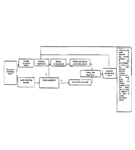
Description of the Drawings
Figure 1 is the workflow diagram of the coal cutter positioning system
according to the
present invention.
Figure 2 is the layout diagram of the coal cutter positioning device
integrating inertial
navigation with laser scanning according to the present invention.
Figure 3 is the internal schematic diagram of the positioning device explosion-
proof
enclosure according to the present invention.
Figure 4 is the algorithm flowchart of the present invention.
In the figures: 1. Coal cutter: 2. Positioning device explosion-proof
enclosure; 3. Laser
signal receiving module; 4. Inertial navigation positioning device; 4-1. Three-
axis
gyroscope; 4-2 Three-axis acceleration meter; 4-3 Inertial navigation
microprocessor; 5.
Laser scanning microprocessor; 6. Upper computer.
Detailed Description of the Embodiments
the present invention is further described with reference to the attached
drawings:
As shown in Figures 2 and 3, the present invention provides a coal cutter
positioning
device integrating inertial navigation with laser scanning, wherein the coal
cutter
positioning device comprises a coal cutter 1, an inertial navigation
positioning device 4, a
laser scanning device, a positioning device explosion-proof enclosure 2 and an
upper
computer 6; the positioning device explosion-proof enclosure 2 and a laser
signal
receiving module of the laser scanning device are fixed on the machine body of
the coal
7
cutter 1; the inertial navigation positioning device 4 is installed in the
positioning device
explosion-proof enclosure 2.
The inertial navigation positioning device 4 comprises a three-axis gyroscope
4-1, a
three-axis acceleration meter 4-2 and an inertial navigation microprocessor 4-
3; the
three-axis gyroscope 4-1 comprises a three-axis gyroscopic sensor; the three-
axis
acceleration meter 4-2 comprises a three-axis acceleration sensor; during the
operating
process of the coal cutter, the inertial navigation positioning device 4
determines the
real-time angular rates in three directions through the three-axis gyroscope 4-
1,
determines the real-time acceleration values in three directions through the
three-axis
acceleration meter 4-2, and samples the data measured by the three-axis
gyroscopic
sensor and the three-axis acceleration sensor to the inertial navigation
microprocessor;
the inertial navigation microprocessor is connected with an upper computer
through a
serial port.
The laser scanning device comprises a laser scanning base station, a laser
signal receiving
module 3 and a laser scanning microprocessor 5; the laser scanning base
station is
arranged in the working area of the coal cutter, the laser scanning
microprocessor 5 is
installed in the positioning device explosion-proof enclosure 2; the laser
signal receiving
module 3 is connected with the laser scanning microprocessor 5, the laser
scanning
microprocessor 5 is connected with an upper computer 6 through the serial port
and
transmits the laser scanning positioning data to the coal cutter positioning
control system
in the upper computer 6; the laser emitted by the laser scanning base station
is received
by the laser signal receiving module on the machine body of the coal cutter,
and the
received time information is acquired and processed by the laser scanning
microprocessor
5; the upper computer 6 makes judgment of data information, and adopts the
fusion
algorithm (the least square method is adopted for determining the weight value
of
coefficients, and the neural network algorithm is adopted for evaluating the
positioning)
to finally determine the position of the coal cutter and realize the accurate
positioning.
Figure 1 is the workflow diagram of the coal cutter positioning system. The
work flow
of the coal cutter positioning system is described in the preamble as E1,-E5.
8
CA 2973038 2019-08-26