Note : Les descriptions sont présentées dans la langue officielle dans laquelle elles ont été soumises.
CA 02465233 2004-04-28
Navigation System for Determining the Course of a Vehicle
The present invention relates to a navigation system for determining the
course of a
vehicle, in particular an underwater craft, of the type described in the
preamble to Patent
Claim 1.
A navigation system that functions according to the principle of inertial
navigation,
using an inertial sensor system, provides precise, independent navigation, but
not for
protracted periods, since errors in measurement made by the inertial-sensor
system lead
to serious inaccuracies in determining position.
It is already known that an inertial navigation system (INS) can be coupled to
a global
1 S positioning system (GPS) so as to exploit the advantageous characteristics
of each
system, which complement each other. Whereas the GPS provides stability over
the
long term, the INS has a higher measurement rate, and a greater dynamic and
robustness
with respect to error (Vik and Fossen, "Nonlinear Observer for Integration of
GPS and
Inertial Navigation System," Proceedings of the IEEE CDC, May 7 2001, Florida,
USA,
pp. 1 -17). The measured values obtained from the GPS and the INS are routed
to an
integrating filter, e.g. a Kalman filter, that estimates the vehicle's
variable status values
such as position, speed, and position, with minimized errors. During
estimation of the
variable status values or status variables, the measurement data obtained from
the
inertial-sensor system are processed directly, which is to say without any
evaluation,
e.g., plausibility checks. The result of this is that the position error
between the two GPS
measurements increases by the squared power over time. If the GPS fails, for
example
as a result of a brief period of movement when submerged, determination of
position
will diverge and in some instances navigation may fail.
It is the task of the present invention to so improve a navigation system of
the type
described in the introduction hereto that it is capable of greater accuracy
and is more
robust with respect to sensor-based errors.
According to the present invention, this objective has been achieved by the
features set
out in Patent Claim 1.
CA 02465233 2004-04-28
The navigation system according to the present invention entails the advantage
that,
because of the use of a model that describes the behaviour of the vehicle or
the
movement of the vehicle mathematically and which is broadened by the
measurement
process and the errors in the vehicle movement resulting from inaccurate
measurements
-hereinafter referred to as the vehicle model-a comparison of the measured
sensor data
with the sensor data that is to be anticipated theoretically is performed. The
measured
values from at least one auxiliary sensor are used to determine the errors of
the vehicle
model and ensure the quality of the vehicle model thereby. In this way, the
method is
robust with respect to sensor drift and has a high level of stability over the
long term, to
the point that the vehicle model is correctly formulated.
Practical embodiments of the navigation system according to the present
invention, with
functional developments and configurations of the present invention are set
out in the
secondary claims.
In order to ensure correct formulation of the vehicle model, according to one
preferred
embodiment of the present invention, a parameter estimator determines the
parameters
of the vehicle model from the unprocessed measured data from the main sensor
system
and/or from the auxiliary sensor system, and the navigation core constantly
matches the
parameters of the vehicle model to the correction parameters supplied from the
parameter estimator; it does this in parallel to the navigation task.
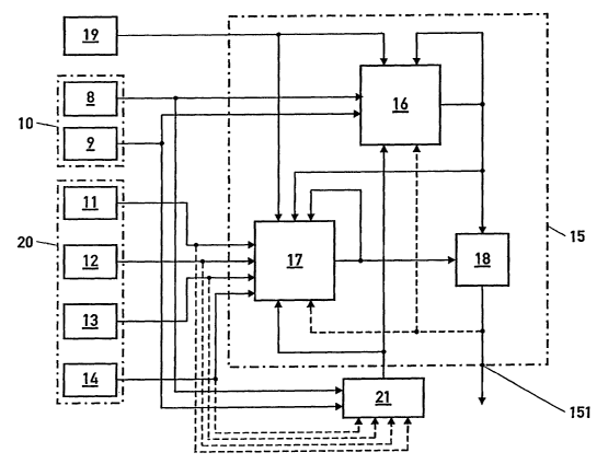
The present invention is described in greater detail below on the basis of an
embodiment
shown in the drawing appended hereto. This drawing is a block circuit diagram
of a
navigation system for determining the course of a water craft, e.g., a surface
vessel or an
underwater craft.
The navigation system comprises a main sensor system 10 that, in the
embodiment
shown, is formed as an inertial sensor system of an inertial navigation system
(INS)
consisting of the sensor gyroscope 8 and accelerometer 9, and a plurality of
sensors 11 -
14 of a so-called auxiliary sensor system 20, as well as a navigation core 15
that, with
the measured values from the sensors 8 -14 from the main and auxiliary sensor
systems
10, 20 outputs error-minimized course data for determining the course at its
output 115.
2
CA 02465233 2004-04-28
The measured values obtained by the sensors 8 -14, referred to as sensor data
hereinafter, are status variables that describe the present status of the
vehicle. Thus, the
inertial sensor system measures the status variables "rate of turn" and
"acceleration" with
the gyroscope 8 and the accelerometer 10; in the case of an underwater craft,
this is done
for three axes. The speed measuring device 11, e.g., Dolog, measures the speed
of the
vehicle through the water and over the bottom; a position sensor 12 measures
the angle
of course, roll angle and angle of pitch; a depth sensor measures water
pressure; and a
position sensor 14, preferably a GPS, measures the time and the position and
speed of
the vehicle. In addition, a control element 19 supplies more control data of
the vehicle,
in the case of an underwater craft, for example, the speed of rotation of the
propeller and
the position of the rudder.
The navigation core 15 contains a vehicle model 16 that mathematically
represents
vehicle movement or vehicle behaviour, the measurement process, and the errors
in
vehicle movement that result from imprecise measurements; it also contains an
error
estimator 17 and a correction element 18, the output from which is applied to
the output
151 of the navigation core. The measured data from the main sensor system 10
are
routed to the vehicle model 16 and the measured data from the auxiliary sensor
system
20 are routed to the error estimator 17. The control data of the control
element 19 are
passed both to the vehicle model 16 and to the error estimator 17. The vehicle
model,
which is realized for example, by means of an integrator with Kalman filters,
the input of
which is connected to the main sensor system 10 and the output of which is
connected
on one side to the input of the error estimator 17 and on the other side to
the input of the
correction element 18, uses the measured data from the main sensor system 10
and the
control data from the control element 19 to predict the vehicle's status
variables such as
position, speed, acceleration, course angle, roll and pitch position, and rate
of turn. The
error estimator 17 that is, for example, configured as an integrator with
Kalman filters,
the input of which is connected to the auxiliary sensors 11-14 of the
auxiliary sensor
system 20 as well as to the control element 19, and the output of which is
connected to
the additional input of the corrector element 18, predicts the errors of
estimation
contained in the predicted status variables, using the predicted status
variables from the
vehicle model 16 and the measured data from the auxiliary sensors 11 -14 and
the
3
CA 02465233 2004-04-28
measure data from the control element 19 to do so. Within the correction
element 18,
the predicted status variables are corrected with the help of the predicted
errors of
estimation and the corrected status variables are output at the output 151 of
the
navigation core 15. The correction element 18 can, for example, be in the form
of a
difference generator that generates the difference or a weighted difference
from its input
values as output values. Additionally-as is indicated in the diagram by the
dashed
lines-the corrected status variables that are taken off at the output of the
correction
element 18 can be passed both to the vehicle model 16 and to the error
estimator 17 so as
to improve the predicted status variables and errors of estimation by means of
a new
computer run.
The measured values from the main sensor system 21 are also routed to a
parameter
estimator 21 in order to prevent false modelling in the navigation core 15.
This uses the
measured values from the main sensor system 10 to match the parameters of the
vehicle
model 16 and the error estimator 17 to the actual dynamic. The parameter
estimator 21
uses a chronological sequence of measured values from the main sensor system
10 and
thereby varies the parameters of the vehicle model until such time as the
measured
values are represented well enough by the values computed with the vehicle
model for
the same time series. These parameters are then passed to the navigation core
15 and the
parameters in the vehicle model 16 and in the error estimator 17 are thereby
matched
during continuous operation.
As is indicated in the diagram by the dashed line, the unprocessed sensor data
from the
auxiliary sensor system 20 can be passed to the parameter estimator 21 in
addition to or
in place of the unprocessed data from the main sensor system 10, and this data
from the
auxiliary sensor system is then processed by the parameter estimator 21 in the
same way
as described heretofore. Not all the auxiliary sensors 11 -14 need be involved
when this
is done; any selection of sensors can be used.
The present invention is not restricted to the embodiment described herein.
One or a
plurality of the auxiliary sensors 11-14 can be included either temporarily or
permanently in the main sensor system 10 in place of the inertial navigation
system
4
CA 02465233 2004-04-28
(INS) or in addition to this. The sensor data from these auxiliary sensors are
routed to
the vehicle model 16 instead of to the error estimator 17, whereas the sensors
that remain
in the auxiliary sensor system send their sensor data to the error estimator
17, as before.
If a plurality of auxiliary sensors are included in the main sensor system, it
is also
possible to incorporate the complete inertial navigation system or only the
individual
sensors 8, 9 of this into the auxiliary sensor system 20 so that their sensor
data then pass
to the error estimator 17.
5